
| Birth | : | 11 Aug 1901 Massies Mill, Nelson County, Virginia, USA |
| Death | : | 2 Jan 1982 Culpeper, Culpeper County, Virginia, USA |
| Burial | : | North Embro Cemetery, Embro, Oxford County Municipality, Canada |
| Coordinate | : | 43.1667920, -80.9040350 |
| Plot | : | Section 9 Block 10 Lot 6 Grave 13 |
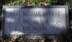
| Inscription | : | Francis M. Bourne wife of Carl B. Bourne Aug. 11, 1901 Jan. 2, 1982 |
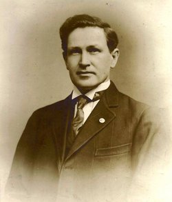
| Description | : | Francis' husband Carl was the brother of Bessie Bourne the second wife of Wyatt Buffon Mahone, Francis' father and thus her step-uncle. Since neither they were all living in the same home, it may have been considered just convenient for them to be married even though he was 22 years older than she was. It was eventually from this situation that she chose to finally be separated in death when she was buried at Jonesboro Cemetery rather than with them. Additional photographs and biographical information is available on Ancestry.com on my family file "Keller Tree 2011" |
frequently asked questions (FAQ):
-
Where is Frances Deane Mahone Bourne's memorial?
Frances Deane Mahone Bourne's memorial is located at: North Embro Cemetery, Embro, Oxford County Municipality, Canada.
-
When did Frances Deane Mahone Bourne death?
Frances Deane Mahone Bourne death on 2 Jan 1982 in Culpeper, Culpeper County, Virginia, USA
-
Where are the coordinates of the Frances Deane Mahone Bourne's memorial?
Latitude: 43.1667920
Longitude: -80.9040350
Family Members:
Parent
Spouse
Flowers:


Nearby Cemetories:
1. North Embro Cemetery
Embro, Oxford County Municipality, Canada
Coordinate: 43.1667920, -80.9040350
2. Methodist Cemetery
Embro, Oxford County Municipality, Canada
Coordinate: 43.1495018, -80.8983841
3. Old Log Church Cemetery
Embro, Oxford County Municipality, Canada
Coordinate: 43.1529121, -80.8626785
4. Scottish Pioneer
Holiday, Oxford County Municipality, Canada
Coordinate: 43.1334100, -80.9626100
5. Red Star Cemetery
Embro, Oxford County Municipality, Canada
Coordinate: 43.1124175, -80.9326897
6. Townline Methodist Church Cemetery
Zorra, Oxford County Municipality, Canada
Coordinate: 43.1842410, -80.9877280
7. Vandecar Cemetery
Vandecar, Oxford County Municipality, Canada
Coordinate: 43.2010640, -80.8148020
8. Oxford Memorial Park Cemetery
Woodstock, Oxford County Municipality, Canada
Coordinate: 43.1148200, -80.8150400
9. Huntingford Christ Church Anglican Cemetery
Huntingford, Oxford County Municipality, Canada
Coordinate: 43.2000280, -80.7960970
10. House of Refuge Cemetery
Woodstock, Oxford County Municipality, Canada
Coordinate: 43.1476245, -80.7873872
11. Lakeside Cemetery
Lakeside, Oxford County Municipality, Canada
Coordinate: 43.2035570, -81.0203780
12. Christ Church Anglican Cemetery
Lakeside, Oxford County Municipality, Canada
Coordinate: 43.2002540, -81.0231730
13. Beachville Cemetery
Beachville, Oxford County Municipality, Canada
Coordinate: 43.0889511, -80.8313599
14. Saint Marys Roman Catholic Cemetery
Woodstock, Oxford County Municipality, Canada
Coordinate: 43.1089400, -80.7998900
15. Broadview United Cemetery
Harrington, Oxford County Municipality, Canada
Coordinate: 43.2436256, -80.9847336
16. Knox Presbyterian Church Cemetery
Harrington, Oxford County Municipality, Canada
Coordinate: 43.2440758, -80.9855423
17. Kintore Methodist Cemetery
Kintore, Oxford County Municipality, Canada
Coordinate: 43.1373300, -81.0343700
18. Kintore Presbyterian Cemetery
Kintore, Oxford County Municipality, Canada
Coordinate: 43.1376900, -81.0349500
19. Anglican Cemetery
Woodstock, Oxford County Municipality, Canada
Coordinate: 43.1426000, -80.7653300
20. Woodstock Baptist Cemetery
Woodstock, Oxford County Municipality, Canada
Coordinate: 43.1416460, -80.7655790
21. Woodstock Presbyterian Cemetery
Woodstock, Oxford County Municipality, Canada
Coordinate: 43.1409440, -80.7651600
22. Hillview Cemetery
Woodstock, Oxford County Municipality, Canada
Coordinate: 43.1206703, -80.7675400
23. Ingersoll Rural Cemetery
Ingersoll, Oxford County Municipality, Canada
Coordinate: 43.0545040, -80.8732690
24. Sacred Heart Cemetery
Ingersoll, Oxford County Municipality, Canada
Coordinate: 43.0514300, -80.8917200