
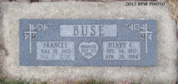
Frances Ernesti Buse
| Birth | : | 18 May 1915 Aloys, Cuming County, Nebraska, USA |
| Death | : | 17 Nov 2008 Dodge, Dodge County, Nebraska, USA |
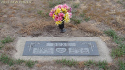
| Burial | : | Grandville Cemetery, Grandville, Kent County, USA |
| Coordinate | : | 42.9043999, -85.7514038 |
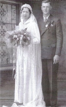
| Description | : | Daughter of Conrad and Elizabeth Heimann Ernesti. She grew up on the farm and attended St. Aloysius School. On October 20, 1936 she married Henry Buse at St. Aloysius Catholic Church. The couple farmed north of West Point, retiring into West Point in the 1990's. Frances was a member of St. Mary's Catholic Church, Guild and Catholic Daughters. She enjoyed her large vegetable garden and flowers. She was known for her baking and embroidery. Survivors include sons; Ralph (Evelyn) and Jerome (Rose) all of West Point, sisters; Lenora Sindelar of Schuyler and Adella Ruskamp of Dodge, grandchildren; Mark (Kathy)Buse, Pat Buse, Lori... Read More |
frequently asked questions (FAQ):
-
Where is Frances Ernesti Buse's memorial?
Frances Ernesti Buse's memorial is located at: Grandville Cemetery, Grandville, Kent County, USA.
-
When did Frances Ernesti Buse death?
Frances Ernesti Buse death on 17 Nov 2008 in Dodge, Dodge County, Nebraska, USA
-
Where are the coordinates of the Frances Ernesti Buse's memorial?
Latitude: 42.9043999
Longitude: -85.7514038
Family Members:
Parent

Spouse
Siblings
Flowers:


Nearby Cemetories:
1. Grandville Cemetery
Grandville, Kent County, USA
Coordinate: 42.9043999, -85.7514038
2. River Bend Cemetery
Walker, Kent County, USA
Coordinate: 42.9352989, -85.7750015
3. Jenison Cemetery
Jenison, Ottawa County, USA
Coordinate: 42.8897018, -85.8019028
4. Smallpox Cemetery
Georgetown Township, Ottawa County, USA
Coordinate: 42.8994500, -85.8063100
5. Floral View Memorial Gardens
Jenison, Ottawa County, USA
Coordinate: 42.8699989, -85.8032990
6. Resurrection Cemetery
Wyoming, Kent County, USA
Coordinate: 42.8905983, -85.6819000
7. Ridgeview Memorial Gardens
Georgetown Township, Ottawa County, USA
Coordinate: 42.8632600, -85.8023900
8. Hanley Cemetery
Jenison, Ottawa County, USA
Coordinate: 42.8565090, -85.7924940
9. Sleepy Hollow Pet Cemetery and Crematory
Byron Center, Kent County, USA
Coordinate: 42.8477040, -85.7329940
10. Holy Trinity Columbarium
Wyoming, Kent County, USA
Coordinate: 42.8669010, -85.6847490
11. Shackhuddle Cemetery
Georgetown Township, Ottawa County, USA
Coordinate: 42.8634460, -85.8229030
12. Boynton Cemetery
Byron Center, Kent County, USA
Coordinate: 42.8377991, -85.7433014
13. Saint Pauls Anglican Church Columbarium
Grand Rapids, Kent County, USA
Coordinate: 42.9711200, -85.7321700
14. Haire Cemetery
Jenison, Ottawa County, USA
Coordinate: 42.9363260, -85.8374910
15. Rosedale Memorial Park
Tallmadge Township, Ottawa County, USA
Coordinate: 42.9721160, -85.7876870
16. Georgetown Township Cemetery
Hudsonville, Ottawa County, USA
Coordinate: 42.8941710, -85.8519780
17. Lowing Cemetery
Jenison, Ottawa County, USA
Coordinate: 42.9219444, -85.8525000
18. Rest Lawn Memorial Park
Grand Rapids, Kent County, USA
Coordinate: 42.9007988, -85.6438980
19. Saint Andrews Catholic Cemetery
Grand Rapids, Kent County, USA
Coordinate: 42.9463997, -85.6567001
20. Oakhill Cemetery
Grand Rapids, Kent County, USA
Coordinate: 42.9411011, -85.6517029
21. Gerald R Ford Museum
Grand Rapids, Kent County, USA
Coordinate: 42.9668140, -85.6771000
22. Kent Memorial Gardens
Byron Center, Kent County, USA
Coordinate: 42.8356018, -85.6883011
23. Westminster Presbyterian Church Columbarium
Grand Rapids, Kent County, USA
Coordinate: 42.9619070, -85.6646760
24. Mount Calvary Cemetery
Grand Rapids, Kent County, USA
Coordinate: 42.9846992, -85.7043991