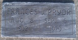
Frances Juanita Stout Pryor
| Birth | : | 8 Aug 1912 Picher, Ottawa County, Oklahoma, USA |
| Death | : | 16 Sep 1979 Pittsburg, Crawford County, Kansas, USA |
| Burial | : | Ancient Cemetery, Yarmouth Port, Barnstable County, USA |
| Coordinate | : | 41.7111015, -70.2332993 |
| Description | : | Frances Pryor Frances Pryor, 67, of 1024 E. 14th, died at 7:45 pm Sunday, Sept. 16, 1979, at Mt. Carmel Medical Center, where she had been a patient since Sept. 4. She was a resident of Crestview Lodge in Arma since August 8. She was born Aug. 8, 1912, in Picher, Okla. She moved to Pittsburg as a young girl and lived here most of her life. Survivors include two sons, John F. Pryor, Sr., of 409 N. Chestnut, and James F. Pryor, of 603 E. 21st; one daughter Helen, of Zion, Ill.; twenty grandchildren and nine great grandchildren. Funeral arrangements are in complete... Read More |
frequently asked questions (FAQ):
-
Where is Frances Juanita Stout Pryor's memorial?
Frances Juanita Stout Pryor's memorial is located at: Ancient Cemetery, Yarmouth Port, Barnstable County, USA.
-
When did Frances Juanita Stout Pryor death?
Frances Juanita Stout Pryor death on 16 Sep 1979 in Pittsburg, Crawford County, Kansas, USA
-
Where are the coordinates of the Frances Juanita Stout Pryor's memorial?
Latitude: 41.7111015
Longitude: -70.2332993
Family Members:
Spouse
Children
Flowers:
Nearby Cemetories:
1. Thacher Property Burial Ground
Yarmouth Port, Barnstable County, USA
Coordinate: 41.7084800, -70.2438500
2. Bass Hole Memorial Garden
Yarmouth Port, Barnstable County, USA
Coordinate: 41.7228810, -70.2355470
3. Woodside Cemetery
Yarmouth Port, Barnstable County, USA
Coordinate: 41.7000008, -70.2472000
4. Iyanough Gravesite
Cummaquid, Barnstable County, USA
Coordinate: 41.7014900, -70.2754100
5. Howes Family Cemetery
Dennis, Barnstable County, USA
Coordinate: 41.7344017, -70.2014008
6. Cummaquid Cemetery
Cummaquid, Barnstable County, USA
Coordinate: 41.6974700, -70.2804850
7. Dennis Village Cemetery
Dennis, Barnstable County, USA
Coordinate: 41.7373466, -70.1924286
8. Hall Cemetery
Dennis, Barnstable County, USA
Coordinate: 41.7435989, -70.1943970
9. Chandler Gray Cemetery
Yarmouth, Barnstable County, USA
Coordinate: 41.6693993, -70.2509995
10. Memorial Park
South Yarmouth, Barnstable County, USA
Coordinate: 41.6776350, -70.1925520
11. Quaker Cemetery
Dennis, Barnstable County, USA
Coordinate: 41.7043991, -70.1713028
12. Cobb's Hill Cemetery East and West
Barnstable, Barnstable County, USA
Coordinate: 41.7008018, -70.2994003
13. Nobscusset Indian Burial Ground
Dennis, Barnstable County, USA
Coordinate: 41.7451330, -70.1830350
14. Indian Memorial Cemetery
South Yarmouth, Barnstable County, USA
Coordinate: 41.6704400, -70.1913900
15. Corporation Beach Memorial Park
Dennis, Barnstable County, USA
Coordinate: 41.7507000, -70.1875000
16. Georgetown Cemetery
South Yarmouth, Barnstable County, USA
Coordinate: 41.6731415, -70.1818695
17. Pine Grove Cemetery
South Yarmouth, Barnstable County, USA
Coordinate: 41.6680984, -70.1889038
18. Paddock Cemetery
East Dennis, Barnstable County, USA
Coordinate: 41.7430992, -70.1735992
19. Quaker Meeting House Cemetery
South Yarmouth, Barnstable County, USA
Coordinate: 41.6689987, -70.1846008
20. Saint Marys Church Memorial Gardens
Barnstable, Barnstable County, USA
Coordinate: 41.7036000, -70.3090000
21. Bass River Baptist Church Cemetery
Bass River, Barnstable County, USA
Coordinate: 41.6591988, -70.1996994
22. Oak Ridge Cemetery
South Dennis, Barnstable County, USA
Coordinate: 41.7111015, -70.1556015
23. Saint Davids Memorial Yard
South Yarmouth, Barnstable County, USA
Coordinate: 41.6621100, -70.1915400
24. Packet Landing Veterans Memorial Park
Bass River, Barnstable County, USA
Coordinate: 41.6662000, -70.1835000


