
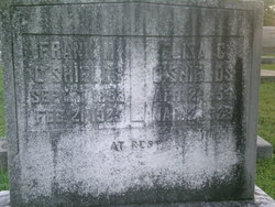

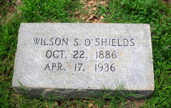
Francis Marion “Frank” O'Shields
| Birth | : | 7 Sep 1853 Spartanburg County, South Carolina, USA |
| Death | : | 21 Feb 1925 Spartanburg, Spartanburg County, South Carolina, USA |
| Burial | : | Our Lady of the Light Catholic Cemetery, La Luz, Otero County, USA |
| Coordinate | : | 32.9790340, -105.9500560 |
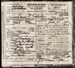
| Description | : | Francis 'Frank ' Marion O'Shields age 71 husband of Elizabeth Vise O'Shields, Mr O'Shields was head of the Blacksmith Shops of the Southern Railroad System at Hayne and brother of W.G.S O'Shields County Auditor died at 10;30 O'clock Saturday Morning at his home on Hayne after a long illiness. he was the -- Son of Wiley Drayton & Julia Smith O'Shields Frank and Elizabeth were members of Friendship Baptist Church in Pauline for 52 years , Spartanburg Co. his following brothers survive W.G.S O'Shields ,J.M O'Shields and Henry W O'Shields |
frequently asked questions (FAQ):
-
Where is Francis Marion “Frank” O'Shields's memorial?
Francis Marion “Frank” O'Shields's memorial is located at: Our Lady of the Light Catholic Cemetery, La Luz, Otero County, USA.
-
When did Francis Marion “Frank” O'Shields death?
Francis Marion “Frank” O'Shields death on 21 Feb 1925 in Spartanburg, Spartanburg County, South Carolina, USA
-
Where are the coordinates of the Francis Marion “Frank” O'Shields's memorial?
Latitude: 32.9790340
Longitude: -105.9500560
Family Members:
Parent
Spouse
Siblings
Children

Flowers:


Nearby Cemetories:
1. Our Lady of the Light Catholic Cemetery
La Luz, Otero County, USA
Coordinate: 32.9790340, -105.9500560
2. La Luz Community Cemetery
La Luz, Otero County, USA
Coordinate: 32.9789660, -105.9493910
3. White Dove of the Desert Cemetery
Alamogordo, Otero County, USA
Coordinate: 32.9372770, -105.9419780
4. Little Chapel in the Desert Columbarium
Alamogordo, Otero County, USA
Coordinate: 32.9372670, -105.9419760
5. New Mexico Museum of Space History
Alamogordo, Otero County, USA
Coordinate: 32.9210610, -105.9206700
6. Saint Jude Columbarium
Otero County, USA
Coordinate: 32.9055550, -105.9360150
7. Saint Johns Columbarium
Alamogordo, Otero County, USA
Coordinate: 32.9015940, -105.9561990
8. Immaculate Conception Catholic Cemetery
Alamogordo, Otero County, USA
Coordinate: 32.8900909, -105.9457474
9. Monte Vista Cemetery
Alamogordo, Otero County, USA
Coordinate: 32.8901787, -105.9434662
10. Sacred Heart Cemetery
Tularosa, Otero County, USA
Coordinate: 33.0809000, -106.0190000
11. Fairview Cemetery
Tularosa, Otero County, USA
Coordinate: 33.0820740, -106.0194110
12. Mountain Park Cemetery
Mountain Park, Otero County, USA
Coordinate: 32.9428680, -105.8144890
13. Seven Graves Cemetery
Cloudcroft, Otero County, USA
Coordinate: 32.9623740, -105.7431120
14. Boles Acres Cemetery
Boles Acres, Otero County, USA
Coordinate: 32.8061390, -105.9850210
15. Walters Cemetery
Otero County, USA
Coordinate: 33.1585999, -105.8563995
16. Our Lady of Guadalupe Cemetery
Bent, Otero County, USA
Coordinate: 33.1591970, -105.8546460
17. Marcia Cemetery
Marcia, Otero County, USA
Coordinate: 32.8280556, -105.7552778
18. Mescalero Indian Cemetery
Mescalero, Otero County, USA
Coordinate: 33.1474991, -105.7755966
19. Blazer Cemetery
Mescalero, Otero County, USA
Coordinate: 33.1567612, -105.7859573
20. Saint Joseph Apache Mission Churchyard
Mescalero, Otero County, USA
Coordinate: 33.1548850, -105.7674670
21. Bass Cemetery
Otero County, USA
Coordinate: 32.9060730, -105.6831340
22. Baird Cemetery
Otero County, USA
Coordinate: 32.9542260, -105.6471740
23. James Canyon Cemetery
Mayhill, Otero County, USA
Coordinate: 32.9433000, -105.6194000
24. Parker Posey Cemetery
Cloudcroft, Otero County, USA
Coordinate: 32.9347380, -105.6054980