


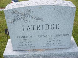
Francis R “Chink” Patridge
| Birth | : | 14 Jul 1919 Haverhill, Grafton County, New Hampshire, USA |
| Death | : | 10 Mar 2010 Haverhill, Grafton County, New Hampshire, USA |
| Burial | : | Center Haverhill Cemetery, Center Haverhill, Grafton County, USA |
| Coordinate | : | 44.0770650, -71.9868740 |
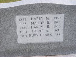
| Description | : | Francis Russell "Chink" Patridge, 90, of County Road, died March 10, 2010 at his residence. He was born in Haverhill, July 14, 1919, the son of Harry M. and Maude (Bowles) Patridge. He graduated Haverhill Academy, Class of 1937 and served in the U.S. Army during World War II and received a Good Conduct Medal. In January 1944 he was designated a sniper in the 10th Armored Tigers. While assigned to Company B, 20th Armored Infantry Battalion, 10th Armored Division, during the Battle of the Bulge, he received a Bronze Star medal for heroic achievement for his actions on December... Read More |
frequently asked questions (FAQ):
-
Where is Francis R “Chink” Patridge's memorial?
Francis R “Chink” Patridge's memorial is located at: Center Haverhill Cemetery, Center Haverhill, Grafton County, USA.
-
When did Francis R “Chink” Patridge death?
Francis R “Chink” Patridge death on 10 Mar 2010 in Haverhill, Grafton County, New Hampshire, USA
-
Where are the coordinates of the Francis R “Chink” Patridge's memorial?
Latitude: 44.0770650
Longitude: -71.9868740
Family Members:
Parent
Spouse
Siblings

Flowers:


Nearby Cemetories:
1. Center Haverhill Cemetery
Center Haverhill, Grafton County, USA
Coordinate: 44.0770650, -71.9868740
2. Abbott Cemetery
North Haverhill, Grafton County, USA
Coordinate: 44.0821730, -72.0186420
3. Oxbow Cemetery
Newbury, Orange County, USA
Coordinate: 44.0881830, -72.0486670
4. East Haverhill Cemetery
East Haverhill, Grafton County, USA
Coordinate: 44.0289688, -71.9889297
5. Horse Meadow Annex Cemetery
North Haverhill, Grafton County, USA
Coordinate: 44.1056820, -72.0408260
6. Horse Meadow Cemetery
North Haverhill, Grafton County, USA
Coordinate: 44.1068880, -72.0405500
7. Number 6 Cemetery
East Haverhill, Grafton County, USA
Coordinate: 44.0326400, -71.9518600
8. Swiftwater Cemetery
Bath, Grafton County, USA
Coordinate: 44.1303400, -71.9574300
9. Ladd Street Cemetery
Haverhill, Grafton County, USA
Coordinate: 44.0439600, -72.0532800
10. Pine Grove Cemetery
Woodsville, Grafton County, USA
Coordinate: 44.1380997, -72.0188980
11. West Cemetery
Benton, Grafton County, USA
Coordinate: 44.1033700, -71.9014000
12. East Cemetery
Benton, Grafton County, USA
Coordinate: 44.0985985, -71.8846970
13. Rodimon-Cross Cemetery
Piermont, Grafton County, USA
Coordinate: 43.9901100, -71.9924500
14. Wells River Cemetery
Wells River, Orange County, USA
Coordinate: 44.1535988, -72.0547028
15. Lund Cemetery
Warren, Grafton County, USA
Coordinate: 43.9882800, -71.9589200
16. Oliverian Road Cemetery
Benton, Grafton County, USA
Coordinate: 43.9978145, -71.9209265
17. Bath Village Cemetery
Bath, Grafton County, USA
Coordinate: 44.1693500, -71.9617800
18. West Bath Cemetery
Bath, Grafton County, USA
Coordinate: 44.1750930, -71.9865080
19. West Newbury Cemetery
West Newbury, Orange County, USA
Coordinate: 44.0591800, -72.1246900
20. Town House Cemetery
Newbury Center, Orange County, USA
Coordinate: 44.1066322, -72.1256943
21. Brown Farmstead Cemetery
Benton, Grafton County, USA
Coordinate: 44.0778000, -71.8420830
22. Carbee Cemetery
Bath, Grafton County, USA
Coordinate: 44.1724640, -72.0466980
23. Rogers Hill Cemetery
West Newbury, Orange County, USA
Coordinate: 44.0550003, -72.1322021
24. Boltonville Cemetery
Boltonville, Orange County, USA
Coordinate: 44.1575012, -72.0877991