
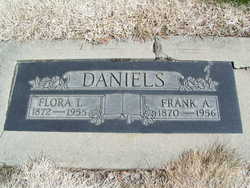
Frank Allen Daniels
| Birth | : | 28 Mar 1870 Iowa, USA |
| Death | : | 17 May 1956 Wenatchee, Chelan County, Washington, USA |
| Burial | : | Cayucos-Morro Bay District Cemetery, Cayucos, San Luis Obispo County, USA |
| Coordinate | : | 35.4371986, -120.8850021 |
| Description | : | Signer of the Declaration of Independence. Washington Death Certificate Name Frank Allen Daniels Death Date 17 May 1956 Death Place Wenatchee, Chelan, Washington Gender Male Age at Death 86 years Estimated Birth Year 1870 Father's Name S. B. Daniels Father's Birth Place Mother's Name Sarah Film Number 2033619 Digital GS Number 4224567 Image Number 1271 Volume/Page/Certificate Number cn 8175 children: Edna F Daniels Visnaw b: 27 Se 1893 d: 22 Sep 1983, Fred Daniels, Clifford Carpenter Daniels b: 18 Dec 1896 d: 25 Feb 1978 |
frequently asked questions (FAQ):
-
Where is Frank Allen Daniels's memorial?
Frank Allen Daniels's memorial is located at: Cayucos-Morro Bay District Cemetery, Cayucos, San Luis Obispo County, USA.
-
When did Frank Allen Daniels death?
Frank Allen Daniels death on 17 May 1956 in Wenatchee, Chelan County, Washington, USA
-
Where are the coordinates of the Frank Allen Daniels's memorial?
Latitude: 35.4371986
Longitude: -120.8850021
Family Members:
Parent
Spouse

Siblings

Children
Flowers:


Nearby Cemetories:
1. St. Peter’s By-the-Sea Episcopal Church Memo
Morro Bay, San Luis Obispo County, USA
Coordinate: 35.3628700, -120.8467400
2. Canet Cemetery
San Luis Obispo County, USA
Coordinate: 35.3522840, -120.7901660
3. Adelaida Cemetery
Adelaida, San Luis Obispo County, USA
Coordinate: 35.5632085, -120.8956170
4. Los Osos Valley Memorial Park
Los Osos, San Luis Obispo County, USA
Coordinate: 35.3053017, -120.8011017
5. Willow Creek Mennonite Cemetery
Wilson Corner, San Luis Obispo County, USA
Coordinate: 35.5890410, -120.8215860
6. Chapel of the Roses Cemetery
Atascadero, San Luis Obispo County, USA
Coordinate: 35.5027340, -120.6881430
7. Atascadero Pine Mountain Cemetery
Atascadero, San Luis Obispo County, USA
Coordinate: 35.4960835, -120.6565582
8. Saint Pauls Episcopal Church Memorial Garden
Cambria, San Luis Obispo County, USA
Coordinate: 35.5575200, -121.0757200
9. Templeton Cemetery
Templeton, San Luis Obispo County, USA
Coordinate: 35.5714455, -120.7022095
10. Dove Cemetery
San Luis Obispo County, USA
Coordinate: 35.4482231, -120.6344299
11. Santa Rosa Cemetery
Cambria, San Luis Obispo County, USA
Coordinate: 35.5662900, -121.0809300
12. Cambria Cemetery
Cambria, San Luis Obispo County, USA
Coordinate: 35.5746994, -121.0922012
13. Adelaida Cemetery
San Luis Obispo County, USA
Coordinate: 35.6563988, -120.8728027
14. Porte Family Cemetery
San Simeon, San Luis Obispo County, USA
Coordinate: 35.6376400, -121.0379800
15. Mission San Luis Obispo Cemetery
San Luis Obispo, San Luis Obispo County, USA
Coordinate: 35.2806600, -120.6645200
16. Old Mission Cemetery
San Luis Obispo, San Luis Obispo County, USA
Coordinate: 35.2670660, -120.6692150
17. San Luis Cemetery
San Luis Obispo, San Luis Obispo County, USA
Coordinate: 35.2644192, -120.6712830
18. Santa Margarita Cemetery
Santa Margarita, San Luis Obispo County, USA
Coordinate: 35.3913994, -120.5880966
19. Saint James Episcopal Church Inurnment Garden
Paso Robles, San Luis Obispo County, USA
Coordinate: 35.6283460, -120.6929780
20. Paso Robles District Cemetery
Paso Robles, San Luis Obispo County, USA
Coordinate: 35.6424700, -120.7035000
21. San Marcos Mennonite Cemetery
San Luis Obispo County, USA
Coordinate: 35.6874570, -120.7995160
22. Creston Cemetery
Creston, San Luis Obispo County, USA
Coordinate: 35.5328640, -120.5121450
23. Estrella Adobe Cemetery
Paso Robles, San Luis Obispo County, USA
Coordinate: 35.6975080, -120.6399460
24. San Miguel District Cemetery
San Miguel, San Luis Obispo County, USA
Coordinate: 35.7392006, -120.7013550