
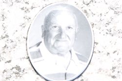
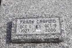
Frank Carpino
| Birth | : | 11 Oct 1927 Roseland, Cherokee County, Kansas, USA |
| Death | : | 9 Oct 2006 Saint Cloud, Osceola County, Florida, USA |
| Burial | : | Prescot Cemetery, Prescot, Metropolitan Borough of Knowsley, England |
| Coordinate | : | 53.4266620, -2.8081590 |
| Description | : | ~✿~ FRANK CARPINO ~✿~ (October 11, 1927 ~ October 9, 2006) *** Veteran U.S. Army (WWII) *** Frank Carpino, 79, of Pittsburg, died at 11 p.m. Monday, Oct. 9, 2006, at the home of his daughter in St. Cloud, Fla. He had been in ill health since December 2005. He was born Oct. 11, 1927, in Roseland, to Mike and Rose Zaccarello Carpino. He graduated from Columbus High school and attended Kansas Teachers College in Pittsburg. He was a veteran of World War II, serving in the Army. He married Alma Jean Ingle on Nov. 21, 1953, at St. Bridget's Catholic Church in Scammon. She... Read More |
frequently asked questions (FAQ):
-
Where is Frank Carpino's memorial?
Frank Carpino's memorial is located at: Prescot Cemetery, Prescot, Metropolitan Borough of Knowsley, England.
-
When did Frank Carpino death?
Frank Carpino death on 9 Oct 2006 in Saint Cloud, Osceola County, Florida, USA
-
Where are the coordinates of the Frank Carpino's memorial?
Latitude: 53.4266620
Longitude: -2.8081590
Family Members:
Parent

Spouse

Siblings
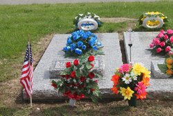
Flowers:


Nearby Cemetories:
1. St. Mary the Virgin Churchyard
Prescot, Metropolitan Borough of Knowsley, England
Coordinate: 53.4284600, -2.8067000
2. St. Nicholas' Churchyard
Whiston, Metropolitan Borough of Knowsley, England
Coordinate: 53.4069736, -2.8028920
3. St. Agnes Roman Catholic
Huyton with Roby, Metropolitan Borough of Knowsley, England
Coordinate: 53.4090600, -2.8320100
4. St. Michael Churchyard
Huyton with Roby, Metropolitan Borough of Knowsley, England
Coordinate: 53.4139560, -2.8396720
5. Knowsley Cemetery
Knowsley, Metropolitan Borough of Knowsley, England
Coordinate: 53.4083240, -2.7847870
6. St Michael Churchyard Extension
Huyton with Roby, Metropolitan Borough of Knowsley, England
Coordinate: 53.4143310, -2.8418050
7. St Ann’s Graveyard
Rainhill, Metropolitan Borough of St Helens, England
Coordinate: 53.4157487, -2.7638276
8. St. Bartholomew's Churchyard
Huyton with Roby, Metropolitan Borough of Knowsley, England
Coordinate: 53.4120023, -2.8556125
9. Christ Church Churchyard
Eccleston, Metropolitan Borough of St Helens, England
Coordinate: 53.4542560, -2.7778900
10. St Bartholomew's Churchyard
Rainhill, Metropolitan Borough of St Helens, England
Coordinate: 53.4076231, -2.7513287
11. St. Mary's Churchyard
Knowsley, Metropolitan Borough of Knowsley, England
Coordinate: 53.4561960, -2.8528580
12. Yew Tree Roman Catholic Cemetery
West Derby, Metropolitan Borough of Liverpool, England
Coordinate: 53.4285700, -2.8790700
13. GreenAcres Cemetery
Rainford, Metropolitan Borough of St Helens, England
Coordinate: 53.4713530, -2.8064280
14. St. Helen's Cemetery and Crematorium
St Helens, Metropolitan Borough of St Helens, England
Coordinate: 53.4678993, -2.7607000
15. St. John the Evangelist Churchyard
Knotty Ash, Metropolitan Borough of Liverpool, England
Coordinate: 53.4160757, -2.8913708
16. Windleshaw Chantry
St Helens, Metropolitan Borough of St Helens, England
Coordinate: 53.4672417, -2.7550773
17. St Nicholas Churchyard
St Helens, Metropolitan Borough of St Helens, England
Coordinate: 53.4284660, -2.7213830
18. Friends Meeting House, Hardshaw, St Helens
St Helens, Metropolitan Borough of St Helens, England
Coordinate: 53.4518340, -2.7320414
19. All Saints Churchyard
Childwall, Metropolitan Borough of Liverpool, England
Coordinate: 53.3952880, -2.8816030
20. Broadgreen Jewish Cemetery
Liverpool, Metropolitan Borough of Liverpool, England
Coordinate: 53.4101320, -2.8977320
21. St. Nicholas Churchyard
Halewood, Metropolitan Borough of Knowsley, England
Coordinate: 53.3694400, -2.8284900
22. St. Anne and Blessed Dominic Churchyard
St Helens, Metropolitan Borough of St Helens, England
Coordinate: 53.4330960, -2.7083700
23. St. Peter's Churchyard
Woolton, Metropolitan Borough of Liverpool, England
Coordinate: 53.3759310, -2.8693390
24. St. Mary's Churchyard
Woolton, Metropolitan Borough of Liverpool, England
Coordinate: 53.3750550, -2.8703760