
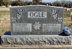
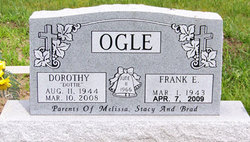
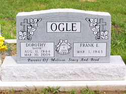
Frank E. Ogle
| Birth | : | 1 Mar 1943 Leon, Butler County, Kansas, USA |
| Death | : | 7 Apr 2009 Chanute, Neosho County, Kansas, USA |
| Burial | : | Calvary Cemetery, Independence, Montgomery County, USA |
| Coordinate | : | 37.2486000, -95.7043991 |
| Plot | : | Sec 200 Blk 5 Lot 125 Sp 4 |
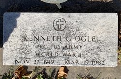
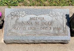
| Description | : | Frank E. Ogle, 66, of Chanute, passed away Tuesday, April 7, 2009 at the Neosho Memorial Regional Medical Center. Frank was born in Leon, Kansas on March 1, 1943, the son of Kenneth Gene and Nina Mae (Typer) Ogle. He served his country in the United States Navy. Frank was united in marriage to Dorothy "Dottie" Malcolm on June 11, 1966 in Chanute. She preceded him in death on March 10, 2008. He was a Foreman at Nu-Wa Campers. Frank is survived by two daughters, Melissa Reinhardt and her husband Kerwin and Stacy Borjas and her husband Tom, both of Chanute; a son, Tim Neyhard... Read More |
frequently asked questions (FAQ):
-
Where is Frank E. Ogle's memorial?
Frank E. Ogle's memorial is located at: Calvary Cemetery, Independence, Montgomery County, USA.
-
When did Frank E. Ogle death?
Frank E. Ogle death on 7 Apr 2009 in Chanute, Neosho County, Kansas, USA
-
Where are the coordinates of the Frank E. Ogle's memorial?
Latitude: 37.2486000
Longitude: -95.7043991
Family Members:
Parent
Spouse
Siblings
Children
Flowers:


Nearby Cemetories:
1. Calvary Cemetery
Independence, Montgomery County, USA
Coordinate: 37.2486000, -95.7043991
2. Mount Hope Cemetery
Independence, Montgomery County, USA
Coordinate: 37.2413300, -95.7060050
3. Saint Andrews Cemetery
Independence, Montgomery County, USA
Coordinate: 37.2566986, -95.6658020
4. Pratt Cemetery
Montgomery County, USA
Coordinate: 37.2324982, -95.6557999
5. Radical Cemetery
Montgomery County, USA
Coordinate: 37.2882996, -95.7416992
6. Le Hunt Cemetery
Montgomery County, USA
Coordinate: 37.2744300, -95.7586200
7. Bethel Cemetery
Independence, Montgomery County, USA
Coordinate: 37.2761002, -95.6457977
8. Montgomery County Poor Farm Cemetery
Liberty, Montgomery County, USA
Coordinate: 37.1888590, -95.6493690
9. Choteau Cemetery
Independence, Montgomery County, USA
Coordinate: 37.3194700, -95.6746700
10. Harmony Cemetery
Cherryvale, Montgomery County, USA
Coordinate: 37.2324982, -95.5950012
11. Krone Cemetery
Montgomery County, USA
Coordinate: 37.3302400, -95.7494600
12. Quaker Cemetery
Elk City, Montgomery County, USA
Coordinate: 37.2395900, -95.8243400
13. Thompson Homestead Cemetery
Liberty, Montgomery County, USA
Coordinate: 37.1767000, -95.6183100
14. Saint Francis Xavier Cemetery
Cherryvale, Montgomery County, USA
Coordinate: 37.2633018, -95.5753021
15. Highland Cemetery
Montgomery County, USA
Coordinate: 37.2092018, -95.8283005
16. Pleasant Dale Cemetery
Cherryvale, Montgomery County, USA
Coordinate: 37.3139700, -95.5860700
17. Simpson Cemetery
Elk City, Montgomery County, USA
Coordinate: 37.3269005, -95.8186035
18. Parker Cemetery
Montgomery County, USA
Coordinate: 37.2630997, -95.8572006
19. Liberty Cemetery
Liberty, Montgomery County, USA
Coordinate: 37.1581890, -95.6001580
20. Spindletop Cemetery
Cherryvale, Montgomery County, USA
Coordinate: 37.2958400, -95.5570700
21. Centennial Cemetery
Cherryvale, Montgomery County, USA
Coordinate: 37.2296982, -95.5466995
22. Spring Hill Cemetery
Montgomery County, USA
Coordinate: 37.1235600, -95.6595500
23. Farm Ridge Cemetery
Elk City, Montgomery County, USA
Coordinate: 37.3560982, -95.8019028
24. Hinton Cemetery
Liberty, Montgomery County, USA
Coordinate: 37.1384900, -95.6101000