
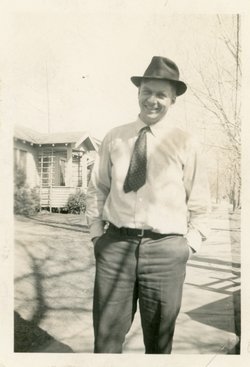
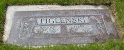

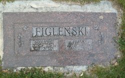
Frank Figlenski
| Birth | : | 27 Jan 1900 Pulaski, Brown County, Wisconsin, USA |
| Death | : | 1 Dec 1977 Omak, Okanogan County, Washington, USA |
| Burial | : | Terry Cemetery, Terry, Lawrence County, USA |
| Coordinate | : | 44.3344290, -103.8165110 |
| Description | : | OBITUARY: "OMAK - Frank Figlenski, 77, Omak, a long-time resident of this area, died in a local hospital on Thursday morning. Born in Pulaski, Wis., Jan, 27, 1900, he moved to Tunk Valley homestead with his family in 1904. He attended school at St. Mary's Mission and was taught by the founder of the mission, Rev. DeRouge. He also served as an altar boy at that time. In 1928, he married Marjorie Sutton in Okanogan. He operated a saw mill and logged in Tunk Creek. In 1934, he purchaed an automobile garage and in 1938, he added the Dodge dealership which he operated until... Read More |
frequently asked questions (FAQ):
-
Where is Frank Figlenski's memorial?
Frank Figlenski's memorial is located at: Terry Cemetery, Terry, Lawrence County, USA.
-
When did Frank Figlenski death?
Frank Figlenski death on 1 Dec 1977 in Omak, Okanogan County, Washington, USA
-
Where are the coordinates of the Frank Figlenski's memorial?
Latitude: 44.3344290
Longitude: -103.8165110
Family Members:
Parent
Spouse

Siblings
Children
Flowers:


Nearby Cemetories:
1. Terry Cemetery
Terry, Lawrence County, USA
Coordinate: 44.3344290, -103.8165110
2. West Lead Cemetery
Lead, Lawrence County, USA
Coordinate: 44.3484001, -103.7779999
3. South Lead Cemetery
Lead, Lawrence County, USA
Coordinate: 44.3478510, -103.7606260
4. Holy Cross Cemetery
Englewood, Lawrence County, USA
Coordinate: 44.2818985, -103.8047028
5. Mountain Lawn Cemetery
Englewood, Lawrence County, USA
Coordinate: 44.2818985, -103.8047028
6. Preston Ghost Town Cemetery
Preston, Lawrence County, USA
Coordinate: 44.3577500, -103.8871670
7. Carbonate Cemetery
Maurice, Lawrence County, USA
Coordinate: 44.4000000, -103.8680500
8. Mount Moriah Cemetery
Deadwood, Lawrence County, USA
Coordinate: 44.3760986, -103.7253036
9. Saint Ambrose Cemetery
Deadwood, Lawrence County, USA
Coordinate: 44.3821983, -103.7266998
10. Carr Cemetery
Hanna, Lawrence County, USA
Coordinate: 44.2411003, -103.8606033
11. Dumont Cemetery
Lawrence County, USA
Coordinate: 44.2270000, -103.7860000
12. Oak Ridge Cemetery
Deadwood, Lawrence County, USA
Coordinate: 44.3891983, -103.6766968
13. Roubaix Cemetery
Roubaix, Lawrence County, USA
Coordinate: 44.2789380, -103.6656600
14. Galena Cemetery
Galena, Lawrence County, USA
Coordinate: 44.3349220, -103.6438410
15. Rose Hill Cemetery
Spearfish, Lawrence County, USA
Coordinate: 44.4802180, -103.8509270
16. Bear Gulch Cemetery
Lawrence County, USA
Coordinate: 44.3819008, -104.0325012
17. Anderson Cemetery
Lawrence County, USA
Coordinate: 44.4747009, -103.6896973
18. Mountain Meadow Cemetery
Lawrence County, USA
Coordinate: 44.2038994, -103.6557999
19. Crook City Cemetery
Crook City, Lawrence County, USA
Coordinate: 44.4432100, -103.6241500
20. Whitewood Cemetery
Whitewood, Lawrence County, USA
Coordinate: 44.4617820, -103.6330030
21. Gate of Heaven Cemetery
Saint Onge, Lawrence County, USA
Coordinate: 44.5353000, -103.7237000
22. Little Dane Cemetery
Saint Onge, Lawrence County, USA
Coordinate: 44.5252500, -103.6705540
23. Saint Aloysius Cemetery
Sturgis, Meade County, USA
Coordinate: 44.4141340, -103.5193420
24. Bell Park Cemetery
Rochford, Pennington County, USA
Coordinate: 44.1116982, -103.7466965