
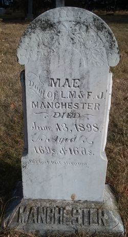
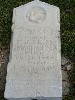
| Birth | : | 18 Jan 1855 Wisconsin, USA |
| Death | : | 7 Aug 1937 Gilroy, Santa Clara County, California, USA |
| Burial | : | Calvary Cemetery, Omaha, Douglas County, USA |
| Coordinate | : | 41.2364006, -96.0294037 |
| Description | : | Frank J. Manchester, Orchard grower of the Rucker District, succumbed in a San Jose hospital Saturday evening, after a brief illness. The 82 yr old orchardist was exceptionally active for his age. Manchester was born in Wisconsin, but had been a well and favorably known resident of this community for many years, settling in the Rucker district 18 years ago. He was a loving father to his family and a devoted husband for the long years of his married life, and leaves his widow. Lydia M. Manchester, married March 7, 1880. Other immediate members of his family are... Read More |
frequently asked questions (FAQ):
-
Where is Frank Jackson Manchester's memorial?
Frank Jackson Manchester's memorial is located at: Calvary Cemetery, Omaha, Douglas County, USA.
-
When did Frank Jackson Manchester death?
Frank Jackson Manchester death on 7 Aug 1937 in Gilroy, Santa Clara County, California, USA
-
Where are the coordinates of the Frank Jackson Manchester's memorial?
Latitude: 41.2364006
Longitude: -96.0294037
Family Members:
Parent


Spouse
Siblings
Children
Flowers:


Nearby Cemetories:
1. Calvary Cemetery
Omaha, Douglas County, USA
Coordinate: 41.2364006, -96.0294037
2. Evergreen Memorial Park Cemetery
Omaha, Douglas County, USA
Coordinate: 41.2393990, -96.0355988
3. Resurrection Cemetery
Omaha, Douglas County, USA
Coordinate: 41.2344208, -96.0365448
4. Ak-Sar-Ben Racetrack Grounds
Omaha, Douglas County, USA
Coordinate: 41.2414703, -96.0159607
5. Saint Andrews Episcopal Church Columbarium
Omaha, Douglas County, USA
Coordinate: 41.2492500, -96.0427500
6. Countryside Community Church Columbarium
Omaha, Douglas County, USA
Coordinate: 41.2483660, -96.0500270
7. Westlawn-Hillcrest Memorial Park
Omaha, Douglas County, USA
Coordinate: 41.2346992, -95.9966965
8. Bohemian Cemetery
Omaha, Douglas County, USA
Coordinate: 41.2388992, -95.9955978
9. Beth El Cemetery
Ralston, Douglas County, USA
Coordinate: 41.2117004, -96.0428009
10. Holy Sepulchre Cemetery
Omaha, Douglas County, USA
Coordinate: 41.2543983, -95.9875031
11. Douglas County Poor Farm Cemetery
Omaha, Douglas County, USA
Coordinate: 41.2437240, -95.9723480
12. Graceland Park Cemetery
Omaha, Douglas County, USA
Coordinate: 41.2113991, -95.9785995
13. Saint Mary Magdalene Cemetery
Omaha, Douglas County, USA
Coordinate: 41.2039420, -95.9850610
14. All Saints Episcopal Church Columbarium
Omaha, Douglas County, USA
Coordinate: 41.2785000, -96.0579000
15. First Central Congregational Columbarium
Omaha, Douglas County, USA
Coordinate: 41.2563456, -95.9658365
16. Nash Chapel Crypt
Omaha, Douglas County, USA
Coordinate: 41.2665090, -95.9721790
17. Saint Mary's Cemetery
Omaha, Douglas County, USA
Coordinate: 41.2042007, -95.9646988
18. Papillion Cemetery
Papillion, Sarpy County, USA
Coordinate: 41.1758003, -96.0410995
19. Portal Cemetery
Sarpy County, USA
Coordinate: 41.1838989, -96.0802994
20. Servants of Mary Cemetery
Omaha, Douglas County, USA
Coordinate: 41.3017170, -96.0258260
21. Prospect Hill Cemetery
Omaha, Douglas County, USA
Coordinate: 41.2780991, -95.9593964
22. Mount Hope Cemetery
Omaha, Douglas County, USA
Coordinate: 41.3041992, -96.0310974
23. Saint Johns Cemetery
Bellevue, Sarpy County, USA
Coordinate: 41.1864014, -95.9682999
24. Pleasant Hill Cemetery
Omaha, Douglas County, USA
Coordinate: 41.2558975, -96.1194687