
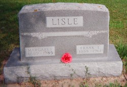

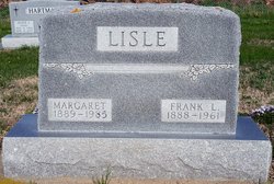
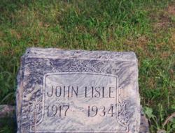
Frank Leroy Lisle
| Birth | : | 30 Oct 1888 Cass County, Iowa, USA |
| Death | : | 28 Nov 1961 Dixon County, Nebraska, USA |
| Burial | : | Fort Okanogan Memorial Cemetery, Okanogan, Okanogan County, USA |
| Coordinate | : | 48.1594009, -119.6632996 |
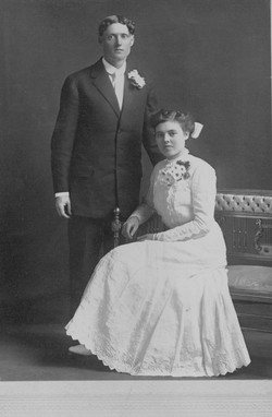
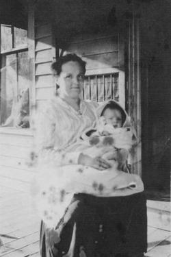
| Description | : | Grandpa was born in the country near Atlantic, Cass County, IA. His father migrated to Dixon County in March 1892 and built a home on a farm in Clark Twp. John Belle hauled logs from the river at Ponca through the weather by sled. Frank was the youngest of two boys in the family. Frank found his father dead in the barn in December 1904. He continued to run the farm and live there with his mother and probably one or more of his siblings. When Frank married in March 1910, he and his bride lived... Read More |
frequently asked questions (FAQ):
-
Where is Frank Leroy Lisle's memorial?
Frank Leroy Lisle's memorial is located at: Fort Okanogan Memorial Cemetery, Okanogan, Okanogan County, USA.
-
When did Frank Leroy Lisle death?
Frank Leroy Lisle death on 28 Nov 1961 in Dixon County, Nebraska, USA
-
Where are the coordinates of the Frank Leroy Lisle's memorial?
Latitude: 48.1594009
Longitude: -119.6632996
Family Members:
Parent

Spouse
Siblings
Children
Flowers:


Nearby Cemetories:
1. Fort Okanogan Memorial Cemetery
Okanogan, Okanogan County, USA
Coordinate: 48.1594009, -119.6632996
2. Elizabeth Osborn Mikel Gravesite
Brewster, Okanogan County, USA
Coordinate: 48.1498900, -119.7514700
3. Locust Grove Cemetery
Brewster, Okanogan County, USA
Coordinate: 48.1114006, -119.7746964
4. Chiliwist Cemetery
Okanogan County, USA
Coordinate: 48.2630997, -119.7363968
5. Paradise Hill Cemetery
Brewster, Okanogan County, USA
Coordinate: 48.1848980, -119.8411900
6. Cameron Lake Pioneer Memorial Cemetery
Malott, Okanogan County, USA
Coordinate: 48.2708330, -119.5700000
7. Malott Community Cemetery
Malott, Okanogan County, USA
Coordinate: 48.2925000, -119.7047300
8. Bridgeport Cemetery
Bridgeport, Douglas County, USA
Coordinate: 48.0050000, -119.6738800
9. Packwood Memorial Cemetery
Dyer, Douglas County, USA
Coordinate: 48.0118305, -119.8178880
10. Pateros Cemetery
Pateros, Okanogan County, USA
Coordinate: 48.0516600, -119.9097300
11. Okanogan City Cemetery
Okanogan, Okanogan County, USA
Coordinate: 48.3546982, -119.6061020
12. Dick Family Cemetery
Okanogan County, USA
Coordinate: 48.0502700, -119.9241700
13. Miller Family Cemetery
Okanogan County, USA
Coordinate: 48.0530300, -119.9288000
14. Spring Coulee Family Cemetery
Okanogan County, USA
Coordinate: 48.3895950, -119.6289460
15. Methow Cemetery
Methow, Okanogan County, USA
Coordinate: 48.1102982, -120.0124969
16. Omak Memorial Cemetery
Okanogan, Okanogan County, USA
Coordinate: 48.3874000, -119.5565800
17. Okanogan Valley Memorial Gardens
Omak, Okanogan County, USA
Coordinate: 48.3911018, -119.5691986
18. Saint Marys Mission Catholic Cemetery
Omak, Okanogan County, USA
Coordinate: 48.3752800, -119.4452800
19. Kartar Cemetery
Okanogan County, USA
Coordinate: 48.2197100, -119.2694500
20. Sand Flats Cemetery
Omak, Okanogan County, USA
Coordinate: 48.4157600, -119.4836600
21. Brooks Cemetery
Omak, Okanogan County, USA
Coordinate: 48.3786110, -119.3941670
22. Booher Grave
Riverside, Okanogan County, USA
Coordinate: 48.3409070, -119.3244000
23. Buckingham Cemetery
Douglas County, USA
Coordinate: 47.8669014, -119.6286011
24. Stoddard Gravesite
Okanogan, Okanogan County, USA
Coordinate: 48.4531140, -119.5411680