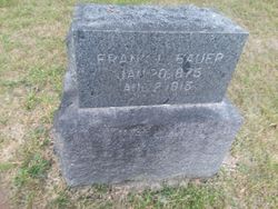
Frank Leslie Bauer
| Birth | : | 20 Jan 1875 Lyons, Clinton County, Iowa, USA |
| Death | : | 2 Aug 1913 Coon Rapids, Carroll County, Iowa, USA |
| Burial | : | Coon Rapids Cemetery, Coon Rapids, Carroll County, USA |
| Coordinate | : | 41.8778000, -94.6678009 |
| Plot | : | Section G |
| Description | : | Coon Rapids Enterprise August 8, 1913 Page 1 Frank L. Bauer, son of Mr. and Mrs. Valentine, Bauer, died Monday morning. He had been afflicted for many years with heart trouble, and of late years most of the time was incapacitated for work though manfully kept at it whenever it was possible for him to do any labor. He followed various kinds of employment since bis majority, clerking, then engaged in business for himself, finally taking up the work of house painting in order to have outdoor work. Frank was a genial man, even though under discouragements. He... Read More |
frequently asked questions (FAQ):
-
Where is Frank Leslie Bauer's memorial?
Frank Leslie Bauer's memorial is located at: Coon Rapids Cemetery, Coon Rapids, Carroll County, USA.
-
When did Frank Leslie Bauer death?
Frank Leslie Bauer death on 2 Aug 1913 in Coon Rapids, Carroll County, Iowa, USA
-
Where are the coordinates of the Frank Leslie Bauer's memorial?
Latitude: 41.8778000
Longitude: -94.6678009
Family Members:
Parent
Spouse
Children
Flowers:
Nearby Cemetories:
1. Union Township Cemetery
Coon Rapids, Carroll County, USA
Coordinate: 41.8781013, -94.6389008
2. Oak Hill Cemetery
Coon Rapids, Carroll County, USA
Coordinate: 41.9053001, -94.7200012
3. Orange Township Cemetery
Guthrie County, USA
Coordinate: 41.8163986, -94.6844025
4. Old Carrollton Cemetery
Carrollton, Carroll County, USA
Coordinate: 41.9233017, -94.7403030
5. Willow Cemetery
Greene County, USA
Coordinate: 41.9067001, -94.5730972
6. Tuttles Grove Cemetery
Guthrie County, USA
Coordinate: 41.8130989, -94.7228012
7. Highland Cemetery
Bayard, Guthrie County, USA
Coordinate: 41.8241997, -94.5717010
8. McCurdy Cemetery
Carroll County, USA
Coordinate: 41.9403000, -94.7649994
9. Viola Center Cemetery
Viola Center, Audubon County, USA
Coordinate: 41.8236008, -94.8016968
10. Saint Josephs Cemetery
Dedham, Carroll County, USA
Coordinate: 41.8993988, -94.8210983
11. Dedham Cemetery
Dedham, Carroll County, USA
Coordinate: 41.8993988, -94.8225021
12. Union Township Cemetery
Guthrie County, USA
Coordinate: 41.7391450, -94.6858030
13. Seeley Township Cemetery
Guthrie County, USA
Coordinate: 41.7318993, -94.6147003
14. Saint Marys Catholic Cemetery
Willey, Carroll County, USA
Coordinate: 41.9783363, -94.8212204
15. Dodge Center Cemetery
Bagley, Guthrie County, USA
Coordinate: 41.8194008, -94.4697037
16. Scranton Township Cemetery
Scranton, Greene County, USA
Coordinate: 42.0306015, -94.5783005
17. Melville Township Cemetery
Audubon County, USA
Coordinate: 41.7439003, -94.8013992
18. Elba Cemetery
Templeton, Carroll County, USA
Coordinate: 41.9068985, -94.9131012
19. Greenbrier Cemetery
Cooper, Greene County, USA
Coordinate: 41.9063988, -94.4218979
20. Luccocks Grove Cemetery
Audubon County, USA
Coordinate: 41.7619019, -94.8653030
21. Cameron Cemetery
Audubon County, USA
Coordinate: 41.8236008, -94.9167023
22. Moffit Grove Cemetery
Yale, Guthrie County, USA
Coordinate: 41.7668991, -94.4539032
23. West Lawn Cemetery
Glidden, Carroll County, USA
Coordinate: 42.0649986, -94.7406006
24. Dillavou Cemetery
Kendrick Township, Greene County, USA
Coordinate: 42.0802994, -94.6138992


