
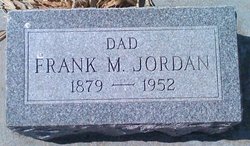
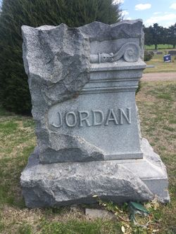
Frank McN Jordan
| Birth | : | 13 Jan 1879 Ottawa County, Kansas, USA |
| Death | : | 20 Jul 1952 Glasco, Cloud County, Kansas, USA |
| Burial | : | Brookside Cemetery, Bridgewater, Lunenburg County, Canada |
| Coordinate | : | 44.3819400, -64.5285800 |
| Plot | : | 96W19 |
| Description | : | Glasco Sun, July 31, 1952, page 1: Frank McN Jordan, son of Edmond and Anna Jordan, was born January 13, 1879, on his father's;s homestead, 4 miles northeast of Glasco. He passed from this life July 20, 1952, aged 73 years, six months and seven days. Frank was the oldest child of a family of six children, two sons and four daughters. His parents, two sisters, and brother preceded him in death. He attended school in their home district No. 47. In his teenage years he worked on his grandfather's farm, cultivating the soil and caring for the livestock. ... Read More |
frequently asked questions (FAQ):
-
Where is Frank McN Jordan's memorial?
Frank McN Jordan's memorial is located at: Brookside Cemetery, Bridgewater, Lunenburg County, Canada.
-
When did Frank McN Jordan death?
Frank McN Jordan death on 20 Jul 1952 in Glasco, Cloud County, Kansas, USA
-
Where are the coordinates of the Frank McN Jordan's memorial?
Latitude: 44.3819400
Longitude: -64.5285800
Family Members:
Parent

Spouse
Siblings
Children
Flowers:


Nearby Cemetories:
1. Brookside Cemetery
Bridgewater, Lunenburg County, Canada
Coordinate: 44.3819400, -64.5285800
2. Saint Joseph's Catholic Cemetery
Bridgewater, Lunenburg County, Canada
Coordinate: 44.3785600, -64.5303900
3. Holy Trinity Anglican Cemetery
Bridgewater, Lunenburg County, Canada
Coordinate: 44.3726110, -64.5000000
4. Hebbville Cemetery
Hebbville, Lunenburg County, Canada
Coordinate: 44.3510700, -64.5384600
5. Dayspring Community Cemetery
Dayspring, Lunenburg County, Canada
Coordinate: 44.3730300, -64.4808200
6. Maple Leaf Cemetery
Conquerall Bank, Lunenburg County, Canada
Coordinate: 44.3647900, -64.4756700
7. Redeemer Lutheran Church Cemetery
Conquerall Bank, Lunenburg County, Canada
Coordinate: 44.3609139, -64.4577333
8. Acacia Cemetery
Conquerall Bank, Lunenburg County, Canada
Coordinate: 44.3586110, -64.4566670
9. Newcombville Cemetery
Newcombville, Lunenburg County, Canada
Coordinate: 44.3752200, -64.6074600
10. Christ Anglican Church Cemetery
Maitland, Lunenburg County, Canada
Coordinate: 44.4312900, -64.4799300
11. Pleasantville Cemetery New
Pleasantville, Lunenburg County, Canada
Coordinate: 44.3372600, -64.4499600
12. Lake Centre Cemetery
Lake Centre, Lunenburg County, Canada
Coordinate: 44.3142200, -64.4834800
13. Silver Cemetery - Rhodes Corner
Rhodes Corner, Lunenburg County, Canada
Coordinate: 44.3776400, -64.4228700
14. Oakhill Cemetery
Conquerall Mills, Lunenburg County, Canada
Coordinate: 44.3058333, -64.5327777
15. Saint James Anglican Cemetery
Conquerall Mills, Lunenburg County, Canada
Coordinate: 44.3058333, -64.5327777
16. Old Pleasantville Cemetery - Pleasantville
Pleasantville, Lunenburg County, Canada
Coordinate: 44.3358800, -64.4394300
17. Pleasantville Cemetery Old
Pleasantville, Lunenburg County, Canada
Coordinate: 44.3355170, -64.4395810
18. Conquerall Mills Lutheran Church Cemetery
Conquerall Mills, Lunenburg County, Canada
Coordinate: 44.3022220, -64.5413880
19. Saint Matthew's Presbyterian Cemetery
Conquerall Mills, Lunenburg County, Canada
Coordinate: 44.3019440, -64.5419440
20. Mulock Cemetery
Rhodes Corner, Lunenburg County, Canada
Coordinate: 44.3675510, -64.4166670
21. Midville Branch Cemetery
Midville Branch, Lunenburg County, Canada
Coordinate: 44.4215800, -64.6320500
22. Sweetland Cemetery
Sweetland, Lunenburg County, Canada
Coordinate: 44.4682400, -64.5079200
23. Middle LaHave Cemetery
Middle LaHave, Lunenburg County, Canada
Coordinate: 44.3308500, -64.4213000
24. Farmville Cemetery
Farmville, Lunenburg County, Canada
Coordinate: 44.4649900, -64.4690100