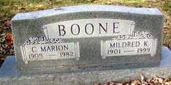
| Birth | : | 29 Feb 1876 Defiance, St. Charles County, Missouri, USA |
| Death | : | 6 May 1953 Saint Charles, St. Charles County, Missouri, USA |
| Burial | : | Rodef Sholom Cemetery, Egg Harbor Township, Atlantic County, USA |
| Coordinate | : | 39.4080000, -74.5670500 |
| Description | : | Frank O'Neal Boone was the son of Charles M Boone and Mary Adelaide (Fulkerson) Boone, who were married December 20, 1868 in St Charles, Missouri and who resided in Femme Osage until her death in 1881. On April 9, 1891 Charles married Margaret Isabel Chilcutt and she finished raising Frank. On November 2, 1904 Frank married Ina Esther Taylor in St Charles. She was the daughter of Francis Marion Taylor and Jemima Ann Elizabeth (Fridley) Taylor of Femme Osage, where the young couple made their home. Frank and Ina were the parents of Charles Marion, Mary Frances, Roland Akers, Esther H and Elizabeth... Read More |
frequently asked questions (FAQ):
-
Where is Frank O'Neal Boone's memorial?
Frank O'Neal Boone's memorial is located at: Rodef Sholom Cemetery, Egg Harbor Township, Atlantic County, USA.
-
When did Frank O'Neal Boone death?
Frank O'Neal Boone death on 6 May 1953 in Saint Charles, St. Charles County, Missouri, USA
-
Where are the coordinates of the Frank O'Neal Boone's memorial?
Latitude: 39.4080000
Longitude: -74.5670500
Family Members:
Parent
Spouse
Siblings
Children
Flowers:
Nearby Cemetories:
1. Rodef Sholom Cemetery
Egg Harbor Township, Atlantic County, USA
Coordinate: 39.4080000, -74.5670500
2. Emeth Shalom Cemetery
Egg Harbor Township, Atlantic County, USA
Coordinate: 39.4067154, -74.5674896
3. Beth Kehillah Cemetery
Egg Harbor Township, Atlantic County, USA
Coordinate: 39.4091250, -74.5689580
4. Ahavas Abram Cemetery
Egg Harbor Township, Atlantic County, USA
Coordinate: 39.3990135, -74.5517273
5. Beth Israel Cemetery
Egg Harbor Township, Atlantic County, USA
Coordinate: 39.3980500, -74.5524300
6. Beth Jacob Cemetery
Egg Harbor Township, Atlantic County, USA
Coordinate: 39.3980500, -74.5524300
7. Mount Calvary Cemetery
Pleasantville, Atlantic County, USA
Coordinate: 39.3983002, -74.5511017
8. Greenwood Cemetery
Pleasantville, Atlantic County, USA
Coordinate: 39.3964005, -74.5327988
9. Atlantic City Cemetery
Pleasantville, Atlantic County, USA
Coordinate: 39.3950691, -74.5314178
10. Salem Cemetery
Pleasantville, Atlantic County, USA
Coordinate: 39.3855286, -74.5325012
11. Atlantic County Almshouse Cemetery
Northfield, Atlantic County, USA
Coordinate: 39.3779920, -74.5409230
12. Mount Pleasant United Methodist Cemetery
Pleasantville, Atlantic County, USA
Coordinate: 39.4050293, -74.5148621
13. Zion United Methodist Church Cemetery
Egg Harbor Township, Atlantic County, USA
Coordinate: 39.3674200, -74.5880000
14. Zion Cemetery
Bargaintown, Atlantic County, USA
Coordinate: 39.3661390, -74.5885100
15. Oxford Circle Burial Ground
Northfield, Atlantic County, USA
Coordinate: 39.3631477, -74.5505753
16. Friends-Central Cemetery
Linwood, Atlantic County, USA
Coordinate: 39.3567200, -74.5605316
17. Laurel Memorial Park and Crematory
Egg Harbor Township, Atlantic County, USA
Coordinate: 39.4565887, -74.5941925
18. Absecon Presbyterian Church Cemetery
Absecon, Atlantic County, USA
Coordinate: 39.4275818, -74.5025711
19. Absecon United Methodist Church Cemetery
Absecon, Atlantic County, USA
Coordinate: 39.4265060, -74.4992840
20. Carmantown Cemetery
Carmantown, Atlantic County, USA
Coordinate: 39.4483250, -74.6446000
21. Christ Episcopal Church Memorial Garden
Somers Point, Atlantic County, USA
Coordinate: 39.3249390, -74.5873160
22. Steelman Family Burial Ground
Somers Point, Atlantic County, USA
Coordinate: 39.3244896, -74.5873566
23. Asbury Methodist Episcopal Church Cemetery
English Creek, Atlantic County, USA
Coordinate: 39.3621483, -74.6706314
24. Palestine Bible Protestant Church Cemetery
Scullville, Atlantic County, USA
Coordinate: 39.3487091, -74.6608810


