Frank R Spiller
| Birth | : | 25 Mar 1893 Ironwood, Gogebic County, Michigan, USA |
| Death | : | 18 Dec 1981 Belt, Cascade County, Montana, USA |
| Burial | : | Pleasant View Cemetery, Belt, Cascade County, USA |
| Coordinate | : | 47.3722000, -110.9088974 |
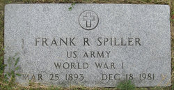
| Inscription | : | US ARMY WORLD WAR I |
| Description | : | Great Falls Tribune (MT), 19 Dec 1981: Frank R. Spiller, 88, Belt, died Friday at his home. Born in Ironwood, Mich., he came to Belt with his family at the age of five and grew up on a ranch north of Belt. He homesteaded east of Brady in 1916, returning to Belt in 1923. Spiller worked eight years with civil service with East Base, now Malmstrom Air Force Base, and worked for different contractors and ranchers over the years. He was a veteran of Army service in World War I. His wife, Bessie, died in 1966. Surviving are three... Read More |
frequently asked questions (FAQ):
-
Where is Frank R Spiller's memorial?
Frank R Spiller's memorial is located at: Pleasant View Cemetery, Belt, Cascade County, USA.
-
When did Frank R Spiller death?
Frank R Spiller death on 18 Dec 1981 in Belt, Cascade County, Montana, USA
-
Where are the coordinates of the Frank R Spiller's memorial?
Latitude: 47.3722000
Longitude: -110.9088974
Family Members:
Parent
Spouse
Siblings
Nearby Cemetories:
1. Pleasant View Cemetery
Belt, Cascade County, USA
Coordinate: 47.3722000, -110.9088974
2. Pleasant Valley Colony Cemetery
Pleasant Valley Colony, Cascade County, USA
Coordinate: 47.3409000, -111.0482000
3. Big Willow Cemetery
Belt, Cascade County, USA
Coordinate: 47.4164009, -110.7444000
4. Tiger Butte Cemetery
Belt, Cascade County, USA
Coordinate: 47.2597008, -111.0108032
5. Cottonwood Bench Cemetery
Cascade County, USA
Coordinate: 47.3128014, -111.1247025
6. Memory Gardens Pet Cemetery
Great Falls, Cascade County, USA
Coordinate: 47.4642000, -111.1287000
7. Keaster Cemetery
Chouteau County, USA
Coordinate: 47.5093500, -110.7410000
8. Sand Coulee Cemetery
Tracy, Cascade County, USA
Coordinate: 47.4219017, -111.1744003
9. Upper Highwood Cemetery
Chouteau County, USA
Coordinate: 47.5092010, -110.6881027
10. Big Stone Colony Cemetery
Big Stone Colony, Cascade County, USA
Coordinate: 47.3986000, -111.2098000
11. McLeish Cemetery
Judith Basin County, USA
Coordinate: 47.3596992, -110.5772018
12. Kibbey Cemetery
Monarch, Cascade County, USA
Coordinate: 47.1742200, -110.7339300
13. Red Butte Cemetery
Eden, Cascade County, USA
Coordinate: 47.3053017, -111.2500000
14. Hebrew Cemetery
Great Falls, Cascade County, USA
Coordinate: 47.4656000, -111.2512000
15. Holy Spirit Catholic Church Columbarium
Great Falls, Cascade County, USA
Coordinate: 47.5024000, -111.2295000
16. Sunrise Presbyterian Church Columbarium
Great Falls, Cascade County, USA
Coordinate: 47.4986500, -111.2407000
17. Monarch Cemetery
Monarch, Cascade County, USA
Coordinate: 47.1263885, -110.7902832
18. Highland Cemetery
Great Falls, Cascade County, USA
Coordinate: 47.4650002, -111.2675018
19. Calvary Cemetery
Gibson Flats, Cascade County, USA
Coordinate: 47.4592018, -111.2707977
20. Old Highland Cemetery
Great Falls, Cascade County, USA
Coordinate: 47.4652220, -111.2678410
21. Mount Olivet Cemetery
Great Falls, Cascade County, USA
Coordinate: 47.4812600, -111.2601700
22. First Congregational UCC Columbarium
Great Falls, Cascade County, USA
Coordinate: 47.4947000, -111.2567000
23. Upper Shonkin Cemetery
Chouteau County, USA
Coordinate: 47.5220000, -110.5770000
24. Hillcrest Lawn Memorial Mausoleum
Great Falls, Cascade County, USA
Coordinate: 47.4894000, -111.2863600

