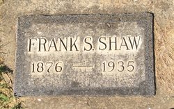
Frank Stevens Shaw
| Birth | : | 28 Jul 1876 Bloomfield, Davis County, Iowa, USA |
| Death | : | 27 Feb 1935 Prairie County, Montana, USA |
| Burial | : | Prairie County Cemetery, Terry, Prairie County, USA |
| Coordinate | : | 46.7881012, -105.3443985 |
| Plot | : | Section C Block 4 Lot 11 |
| Description | : | Funeral services were held Friday afternoon for Frank Stephen Shaw, who passed away Wednesday, February 27, following a paralytic stroke, which he suffered early the previous Sunday. Services were in the Community church and it was crowed with friends and neighbors who came to pay their last respects to a good husband, faithful father and a good friend and accommodating neighbor. Rev Dwight Ramage had charge of the funeral services with Supt C W Grandey assisting him and both gentlemen preached consoling and very complimentary words of the deceased to the stricken family. Mesdames F N Weed and... Read More |
frequently asked questions (FAQ):
-
Where is Frank Stevens Shaw's memorial?
Frank Stevens Shaw's memorial is located at: Prairie County Cemetery, Terry, Prairie County, USA.
-
When did Frank Stevens Shaw death?
Frank Stevens Shaw death on 27 Feb 1935 in Prairie County, Montana, USA
-
Where are the coordinates of the Frank Stevens Shaw's memorial?
Latitude: 46.7881012
Longitude: -105.3443985
Family Members:
Parent
Spouse
Siblings
Children
Flowers:
Nearby Cemetories:
1. Prairie County Cemetery
Terry, Prairie County, USA
Coordinate: 46.7881012, -105.3443985
2. Powder River Supply Depot Cemetery
Terry, Prairie County, USA
Coordinate: 46.7302900, -105.4350800
3. Fallon Cemetery
Prairie County, USA
Coordinate: 46.8168983, -105.1327972
4. Lutheran Cemetery
Fallon, Prairie County, USA
Coordinate: 46.8320800, -105.1120100
5. Little Flat Community Cemetery
Fallon, Prairie County, USA
Coordinate: 46.7659300, -105.0487600
6. Mildred Cemetery
Mildred, Prairie County, USA
Coordinate: 46.6850204, -104.9543457
7. Gluecksthal Lutheran Cemetery
Marsh, Dawson County, USA
Coordinate: 46.8848000, -104.9326000
8. Marsh Cemetery
Dawson County, USA
Coordinate: 46.8828011, -104.9306030
9. Pleasant View Cemetery
Pleasant View, Dawson County, USA
Coordinate: 47.0362630, -104.9326090
10. Little Flat Community Cemetery
Fallon, Prairie County, USA
Coordinate: 46.4598000, -105.0291700
11. Union Cemetery
Dawson County, USA
Coordinate: 47.1822014, -105.2882996
12. Cottonwood Cemetery
Custer County, USA
Coordinate: 46.4294014, -104.9674988
13. Pine Crest Cemetery
Custer County, USA
Coordinate: 46.4564018, -105.7789001
14. Ismay Cemetery
Ismay, Custer County, USA
Coordinate: 46.4982986, -104.8133011
15. Dawson Memorial Park
Glendive, Dawson County, USA
Coordinate: 47.0889015, -104.7746964
16. Pine Hills School Cemetery
Miles City, Custer County, USA
Coordinate: 46.4077988, -105.8167038
17. Knowlton Cemetery
Custer County, USA
Coordinate: 46.3210983, -105.0710983
18. Custer County Cemetery
Miles City, Custer County, USA
Coordinate: 46.3891983, -105.8264008
19. Calvary Cemetery
Miles City, Custer County, USA
Coordinate: 46.3816986, -105.8249969
20. Old Calvary Cemetery
Miles City, Custer County, USA
Coordinate: 46.3807600, -105.8246500
21. Eastern Montana State Veterans Cemetery
Miles City, Custer County, USA
Coordinate: 46.3807564, -105.8246536
22. Rock Springs Cemetery
Rock Springs, Rosebud County, USA
Coordinate: 46.7847800, -106.1411500
23. Dawson County Cemetery
Glendive, Dawson County, USA
Coordinate: 47.1105995, -104.6971970
24. Fort Keogh Cemetery
Custer County, USA
Coordinate: 46.3800011, -105.8874969

