
| Birth | : | 6 Apr 1921 Clay County, Tennessee, USA |
| Death | : | 1 Oct 2008 Cookeville, Putnam County, Tennessee, USA |
| Burial | : | Lester Brown Family Cemetery, Arcott, Clay County, USA |
| Coordinate | : | 36.5205700, -85.5547530 |
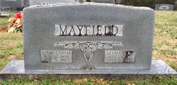
| Description | : | COOKEVILLE -- Funeral services for Frankie (Poppie) Brown Stanley, 87, of Cookeville, will be held at 11 a.m. on Saturday, Oct. 4, from the Cookeville Chapel of Hooper-Huddleston & Horner Funeral Homes and Cremation Services. Burial will be in Lester Brown Cemetery in Clay County. The family will receive friends from 3-7 p.m. today, Friday, Oct. 3, and from 10 a.m. until times of services on Saturday at the funeral home. Mrs. Stanley died Wednesday, Oct. 1, 2008, in Bethesda Health Care Center. She was born April 6, 1921, in Clay County to the late Carl Chism... Read More |
frequently asked questions (FAQ):
-
Where is Frankie “Poppie” Mayfield Stanley's memorial?
Frankie “Poppie” Mayfield Stanley's memorial is located at: Lester Brown Family Cemetery, Arcott, Clay County, USA.
-
When did Frankie “Poppie” Mayfield Stanley death?
Frankie “Poppie” Mayfield Stanley death on 1 Oct 2008 in Cookeville, Putnam County, Tennessee, USA
-
Where are the coordinates of the Frankie “Poppie” Mayfield Stanley's memorial?
Latitude: 36.5205700
Longitude: -85.5547530
Family Members:
Parent

Spouse

Flowers:


Nearby Cemetories:
1. Lester Brown Family Cemetery
Arcott, Clay County, USA
Coordinate: 36.5205700, -85.5547530
2. McColgan Cemetery
Clay County, USA
Coordinate: 36.5163994, -85.5560989
3. Mabry Cemetery
Clay County, USA
Coordinate: 36.5139008, -85.5464020
4. Archibald Plumlee Cemetery
Pine Hill, Clay County, USA
Coordinate: 36.5203018, -85.5682983
5. Hamilton Cemetery
Clay County, USA
Coordinate: 36.5181007, -85.5338974
6. Roberts Cemetery
Celina, Clay County, USA
Coordinate: 36.5066986, -85.5727997
7. Dalton Cemetery
Arcott, Clay County, USA
Coordinate: 36.5429540, -85.5546170
8. Doc Hall Cemetery
Clay County, USA
Coordinate: 36.4995390, -85.5369270
9. Hall Cemetery
Clay County, USA
Coordinate: 36.4994011, -85.5366974
10. Kirk Cemetery
Clay County, USA
Coordinate: 36.4960670, -85.5661650
11. Butlers Landing Cemetery
Celina, Clay County, USA
Coordinate: 36.4941300, -85.5600410
12. John Hamilton Cemetery
Butlers Landing, Clay County, USA
Coordinate: 36.4916010, -85.5489080
13. Emberton Cemetery
Celina, Clay County, USA
Coordinate: 36.4862150, -85.5237040
14. John Fowler Cemetery
Butlers Landing, Clay County, USA
Coordinate: 36.4910900, -85.5972590
15. Varney Andrews Cemetery
Celina, Clay County, USA
Coordinate: 36.5604650, -85.5209530
16. McDonald Cemetery
Baptist Ridge, Clay County, USA
Coordinate: 36.4855995, -85.5119019
17. High Cedar Cemetery
Clay County, USA
Coordinate: 36.4827710, -85.5974970
18. Green Cemetery
Celina, Clay County, USA
Coordinate: 36.5496418, -85.5024450
19. M R Cemetery
Baptist Ridge, Clay County, USA
Coordinate: 36.4769100, -85.5196770
20. Plumlee Cemetery
Celina, Clay County, USA
Coordinate: 36.5694280, -85.5282830
21. Rich-Lynn Family Cemetery
Butlers Landing, Clay County, USA
Coordinate: 36.4794140, -85.5987380
22. Walker Reecer Cemetery
Celina, Clay County, USA
Coordinate: 36.5746290, -85.5480270
23. Amos Kirkpatrick-Tinsley Cemetery
Jackson County, USA
Coordinate: 36.4715080, -85.5867230
24. Hamilton Cemetery
Celina, Clay County, USA
Coordinate: 36.5517271, -85.4970509