
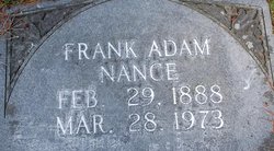
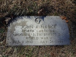
Franklin Adam “Frank” Nance
| Birth | : | 29 Feb 1888 Rowan County, North Carolina, USA |
| Death | : | 28 Mar 1973 Spencer, Rowan County, North Carolina, USA |
| Burial | : | Maple Hill Cemetery, Westfield, Clark County, USA |
| Coordinate | : | 39.4591990, -87.9925120 |
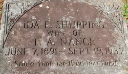
| Description | : | Married 1st Ida Shupping 18 Nov 1917 - Rowan County, NC Married 2nd Cora A Saunders 02 Apr 1939 - Rowan County, NC |
frequently asked questions (FAQ):
-
Where is Franklin Adam “Frank” Nance's memorial?
Franklin Adam “Frank” Nance's memorial is located at: Maple Hill Cemetery, Westfield, Clark County, USA.
-
When did Franklin Adam “Frank” Nance death?
Franklin Adam “Frank” Nance death on 28 Mar 1973 in Spencer, Rowan County, North Carolina, USA
-
Where are the coordinates of the Franklin Adam “Frank” Nance's memorial?
Latitude: 39.4591990
Longitude: -87.9925120
Family Members:
Parent
Spouse
Siblings
Flowers:


Nearby Cemetories:
1. Maple Hill Cemetery
Westfield, Clark County, USA
Coordinate: 39.4591990, -87.9925120
2. Methodist Church Cemetery
Westfield, Clark County, USA
Coordinate: 39.4557304, -88.0004883
3. Broome Cemetery
Montgomery County, USA
Coordinate: 39.4596297, -87.9724841
4. Briscoe Family Burying Ground
Clark County, USA
Coordinate: 39.4628100, -87.9719690
5. Good Hope Cemetery
Westfield, Clark County, USA
Coordinate: 39.4443710, -88.0058100
6. Otterbein Cemetery
Hutton Township, Coles County, USA
Coordinate: 39.4655418, -88.0186462
7. Parker Cemetery #2
Hutton Township, Coles County, USA
Coordinate: 39.4320500, -88.0192200
8. Richwoods Cemetery
Westfield, Clark County, USA
Coordinate: 39.4658510, -87.9410510
9. Wells Cemetery
Ashmore Township, Coles County, USA
Coordinate: 39.4995540, -88.0224370
10. Olmstead Cemetery
Ashmore Township, Coles County, USA
Coordinate: 39.4891750, -88.0447940
11. Stewart Cemetery
Hutton Township, Coles County, USA
Coordinate: 39.4413872, -88.0547256
12. Wiley Brick Cemetery
Hutton Township, Coles County, USA
Coordinate: 39.4281616, -88.0453873
13. Connelly Cemetery
Clark County, USA
Coordinate: 39.4289000, -87.9376000
14. Poulter Cemetery
Kansas, Edgar County, USA
Coordinate: 39.5033500, -87.9447000
15. Enon-Ashmore Cemetery
Ashmore Township, Coles County, USA
Coordinate: 39.5034610, -88.0406840
16. Reed Cemetery
Ashmore Township, Coles County, USA
Coordinate: 39.5141983, -88.0227966
17. Waite Cemetery
Kansas, Edgar County, USA
Coordinate: 39.5139008, -87.9511032
18. Shoots Cemetery
Ashmore Township, Coles County, USA
Coordinate: 39.4824905, -88.0719070
19. Liberty Cemetery
Hutton Township, Coles County, USA
Coordinate: 39.4440613, -88.0775986
20. Sargent Family Cemetery
Hutton Township, Coles County, USA
Coordinate: 39.4133153, -88.0612008
21. Cornwell Cemetery
Kansas, Edgar County, USA
Coordinate: 39.5158005, -87.9383011
22. Ashmore Cemetery
Ashmore, Coles County, USA
Coordinate: 39.5269318, -88.0189972
23. Bean Cemetery
Cleone, Clark County, USA
Coordinate: 39.4201986, -87.9090043
24. Tomlinson Cemetery
Parker Township, Clark County, USA
Coordinate: 39.4291000, -87.9017868