| Birth | : | 4 Dec 1844 Butler, Branch County, Michigan, USA |
| Death | : | 1 May 1925 San Pierre, Starke County, Indiana, USA |
| Burial | : | Delmont Cemetery, Delmont, Douglas County, USA |
| Coordinate | : | 43.2757988, -98.1481018 |
| Plot | : | WPA loc. Gr. 1, Lot 82, Blk. 2 |
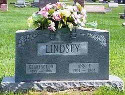
| Inscription | : | FRANKLIN A. LINDSEY DEC. 4, 1844 |
| Description | : | WPA card indicates he died of Intertinal Nephritis, and was buried on 5/4/1925. Information from the microfilm of the WPA Graves Registration Project cards. Contrary to the WPA information, family member Bonnie indicates he was born in 1845 (but tombstone = 1844), in Butler Township, with a middle name of Alphonso. While index to obituaries gives his middle name as Alford, the actual obituary just has middle initial A. Also contrary to the WPA information she indicates he enlisted about 1864, as a Pvt., in Co. F, 11th Regt., Michigan Inf., which is more likely, as... Read More |
frequently asked questions (FAQ):
-
Where is Franklin Alphonse Lindsey's memorial?
Franklin Alphonse Lindsey's memorial is located at: Delmont Cemetery, Delmont, Douglas County, USA.
-
When did Franklin Alphonse Lindsey death?
Franklin Alphonse Lindsey death on 1 May 1925 in San Pierre, Starke County, Indiana, USA
-
Where are the coordinates of the Franklin Alphonse Lindsey's memorial?
Latitude: 43.2757988
Longitude: -98.1481018
Family Members:
Parent
Spouse
Siblings
Children
Flowers:
Nearby Cemetories:
1. Delmont Cemetery
Delmont, Douglas County, USA
Coordinate: 43.2757988, -98.1481018
2. Zion Lutheran Cemetery
Delmont, Douglas County, USA
Coordinate: 43.2822000, -98.1558000
3. Hope Lutheran Cemetery
Delmont, Douglas County, USA
Coordinate: 43.2821999, -98.1568985
4. Old Missouri Cemetery
Delmont, Douglas County, USA
Coordinate: 43.2947006, -98.2043991
5. Emmanuel Lutheran Cemetery
Delmont, Douglas County, USA
Coordinate: 43.3331200, -98.1885800
6. Neusatz Cemetery
Douglas County, USA
Coordinate: 43.3410988, -98.1643982
7. Hoffnungsberg Cemetery
Hutchinson County, USA
Coordinate: 43.2972600, -98.0485700
8. Saint Marys Cemetery
Douglas County, USA
Coordinate: 43.3703000, -98.1119000
9. Oak Hollow Cemetery
Hutchinson County, USA
Coordinate: 43.1963997, -98.0599976
10. Haffner Family Farm Cemetery
Hutchinson County, USA
Coordinate: 43.2134840, -98.0312720
11. New Salem Reformed Cemetery
Charles Mix County, USA
Coordinate: 43.1683006, -98.1271973
12. Zion Baptist Church Cemetery
Wagner, Charles Mix County, USA
Coordinate: 43.1761400, -98.2085800
13. Congregational Church Cemetery
Charles Mix County, USA
Coordinate: 43.1695600, -98.1834300
14. Saint Pauls Lutheran Cemetery
Charles Mix County, USA
Coordinate: 43.1642780, -98.1687250
15. Eigenfeld Evangelical Lutheran Cemetery
Hutchinson County, USA
Coordinate: 43.3549995, -98.0335999
16. Zion Cemetery
Parkston, Hutchinson County, USA
Coordinate: 43.3448100, -97.9939900
17. Saint Peters Cemetery
Douglas County, USA
Coordinate: 43.3847008, -98.2514038
18. Pietz Cemetery
Hutchinson County, USA
Coordinate: 43.2703018, -97.9599991
19. Evangelic Cemetery
Douglas County, USA
Coordinate: 43.4124985, -98.1318970
20. Zion Lutheran Cemetery
Tripp, Hutchinson County, USA
Coordinate: 43.1974400, -97.9917300
21. Pleasant Ridge Cemetery
Armour, Douglas County, USA
Coordinate: 43.3250008, -98.3386002
22. Roberts Chapel Cemetery
Douglas County, USA
Coordinate: 43.4127998, -98.2225037
23. Friedens Reformed Cemetery
Tripp, Hutchinson County, USA
Coordinate: 43.2113991, -97.9657974
24. Grace Hill Cemetery
Tripp, Hutchinson County, USA
Coordinate: 43.2111015, -97.9638977


