
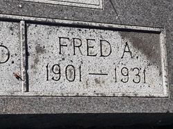
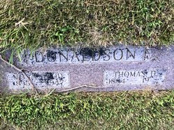
Fred Austin Donaldson
| Birth | : | 19 Nov 1901 Hastings, Adams County, Nebraska, USA |
| Death | : | 12 Nov 1931 Mason City, Cerro Gordo County, Iowa, USA |
| Burial | : | Emmanuel Churchyard, Holcombe, Metropolitan Borough of Bury, England |
| Coordinate | : | 53.6463000, -2.3293400 |
| Plot | : | 2nd Add Block 3 South Lot 64 - 3 |
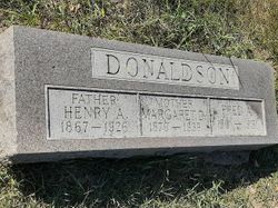
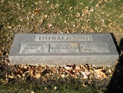
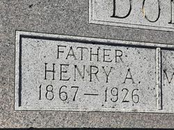
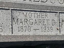
| Description | : | Fred Austin Donaldson, son of Mrs. Margaret Donaldson, 231 Twenty-sixth street southwest, died at a local hospital at 2:40 o'clock Thursday afternoon. He had been ill for six weeks. Mr. Donaldson was born Nov. 19, 1901, at Hastings, Nebr. His father preceded him in death five years ago last March. (partial obituary from the Globe-Gazette, 13 Nov 1931, Page 3 (Mason City, Iowa) |
frequently asked questions (FAQ):
-
Where is Fred Austin Donaldson's memorial?
Fred Austin Donaldson's memorial is located at: Emmanuel Churchyard, Holcombe, Metropolitan Borough of Bury, England.
-
When did Fred Austin Donaldson death?
Fred Austin Donaldson death on 12 Nov 1931 in Mason City, Cerro Gordo County, Iowa, USA
-
Where are the coordinates of the Fred Austin Donaldson's memorial?
Latitude: 53.6463000
Longitude: -2.3293400
Family Members:
Parent
Siblings
Flowers:


Nearby Cemetories:
1. Emmanuel Churchyard
Holcombe, Metropolitan Borough of Bury, England
Coordinate: 53.6463000, -2.3293400
2. Ramsbottom Cemetery
Ramsbottom, Metropolitan Borough of Bury, England
Coordinate: 53.6372986, -2.3271000
3. St. John-in-the-Wilderness Churchyard
Shuttleworth, Metropolitan Borough of Bury, England
Coordinate: 53.6556300, -2.3046500
4. St. John in the Wilderness Shuttleworrth
Walmersley, Metropolitan Borough of Bury, England
Coordinate: 53.6557090, -2.3037740
5. Stubbins Congregational Chapelyard
Rossendale Borough, England
Coordinate: 53.6626600, -2.3110700
6. Rowlands Methodist Churchyard
Summerseat, Metropolitan Borough of Bury, England
Coordinate: 53.6294360, -2.3102920
7. Greenmount United Reformed Churchyard
Greenmount, Metropolitan Borough of Bury, England
Coordinate: 53.6254581, -2.3381465
8. St Mary Churchyard
Hawkshaw, Metropolitan Borough of Bury, England
Coordinate: 53.6307270, -2.3636210
9. Hawkshaw Methodist Church Cemetery
Hawkshaw, Metropolitan Borough of Bury, England
Coordinate: 53.6313490, -2.3674190
10. St Anne Churchyard
Tottington, Metropolitan Borough of Bury, England
Coordinate: 53.6161499, -2.3409030
11. Edenfield Parish Churchyard
Ramsbottom, Metropolitan Borough of Bury, England
Coordinate: 53.6742799, -2.3069304
12. Park Chapel
Walmersley, Metropolitan Borough of Bury, England
Coordinate: 53.6205060, -2.2958590
13. St. John's Churchyard
Tottington, Metropolitan Borough of Bury, England
Coordinate: 53.6141180, -2.3400670
14. Christ Church Churchyard
Walmersley, Metropolitan Borough of Bury, England
Coordinate: 53.6193360, -2.2964630
15. Christ Church Churchyard
Bury, Metropolitan Borough of Bury, England
Coordinate: 53.6194570, -2.2960140
16. Congregational Churchyard
Affetside, Metropolitan Borough of Bury, England
Coordinate: 53.6175200, -2.3705800
17. Methodist Church Churchyard
Edgworth, Blackburn with Darwen Unitary Authority, England
Coordinate: 53.6424280, -2.3962830
18. Edgworth Congregational Chapelyard
Edgworth, Blackburn with Darwen Unitary Authority, England
Coordinate: 53.6476280, -2.3967210
19. Saint Thomas Churchyard
Helmshore, Rossendale Borough, England
Coordinate: 53.6870400, -2.3300000
20. St. Anne's Churchyard
Chapeltown, Blackburn with Darwen Unitary Authority, England
Coordinate: 53.6371710, -2.4030440
21. St. James Churchyard
Bury, Metropolitan Borough of Bury, England
Coordinate: 53.5996770, -2.3214600
22. All Saints Churchyard
Elton, Metropolitan Borough of Bury, England
Coordinate: 53.5965000, -2.3118000
23. Tottington Road Methodist Church Churchyard
Harwood, Metropolitan Borough of Bolton, England
Coordinate: 53.6079190, -2.3904960
24. Haslingden Cemetery
Haslingden, Rossendale Borough, England
Coordinate: 53.6989500, -2.3427700