
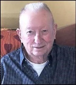
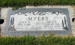
Fred R Myers
| Birth | : | 4 Apr 1926 Washington, USA |
| Death | : | 2019 |
| Burial | : | Otahuhu Public Cemetery, Ōtāhūhū, Auckland Council, New Zealand |
| Coordinate | : | -36.9377500, 174.8432390 |
| Plot | : | Next to Lot65,Blk3,SpC |
| Description | : | MYERS, Fred R. Fred R. Myers was born April 4, 1928 to Frank and Edith Myers in Vossborg, WA. He completed High School in CDA, ID. He joined the US Army in 1944 and served in WWII. Then he worked for Burlington Northern for 42 years out of Hillyard, WA. Fred had two boys with Selma Kunz during their marriage from 1956-1966. In 1974 he married Avis Brisbois, who already had nine children and were married for 27 years until her passing in 2002. They shared many adventures together; traveling around the Country and to AZ while acquiring many wonderful,... Read More |
frequently asked questions (FAQ):
-
Where is Fred R Myers's memorial?
Fred R Myers's memorial is located at: Otahuhu Public Cemetery, Ōtāhūhū, Auckland Council, New Zealand.
-
When did Fred R Myers death?
Fred R Myers death on 2019 in
-
Where are the coordinates of the Fred R Myers's memorial?
Latitude: -36.9377500
Longitude: 174.8432390
Family Members:
Spouse

Flowers:


Nearby Cemetories:
1. Otahuhu Public Cemetery
Ōtāhūhū, Auckland Council, New Zealand
Coordinate: -36.9377500, 174.8432390
2. Holy Trinity Memorial Park
Ōtāhūhū, Auckland Council, New Zealand
Coordinate: -36.9374510, 174.8448580
3. St. Joseph and St. Joachim Catholic Cemetery
Ōtāhūhū, Auckland Council, New Zealand
Coordinate: -36.9436100, 174.8490100
4. Nixon Memorial
Ōtāhūhū, Auckland Council, New Zealand
Coordinate: -36.9499366, 174.8449909
5. St. John's Presbyterian Church Cemetery
Papatoetoe, Auckland Council, New Zealand
Coordinate: -36.9674185, 174.8598178
6. St Matthias Churchyard
Panmure, Auckland Council, New Zealand
Coordinate: -36.9053300, 174.8577200
7. St. Patrick's Roman Catholic Church Cemetery
Panmure, Auckland Council, New Zealand
Coordinate: -36.9029680, 174.8564960
8. Waikaraka Cemetery
Ōnehunga, Auckland Council, New Zealand
Coordinate: -36.9297140, 174.7967170
9. St. John's Church Cemetery
East Tamaki, Auckland Council, New Zealand
Coordinate: -36.9522250, 174.8964540
10. Onehunga Catholic Cemetery
Ōnehunga, Auckland Council, New Zealand
Coordinate: -36.9224360, 174.7884560
11. Our Lady of the Assumption Catholic Church
Ōnehunga, Auckland Council, New Zealand
Coordinate: -36.9223690, 174.7884530
12. Mangere Piriti Urupā St. James Churchyard
Mangere, Auckland Council, New Zealand
Coordinate: -36.9418970, 174.7835260
13. St. Peter's Anglican Cemetery
Ōnehunga, Auckland Council, New Zealand
Coordinate: -36.9227113, 174.7847550
14. Pakuranga Methodist Cemetery
Pakuranga, Auckland Council, New Zealand
Coordinate: -36.9054000, 174.8914900
15. Papatoetoe Cemetery
Papatoetoe, Auckland Council, New Zealand
Coordinate: -36.9893110, 174.8373530
16. Mangere Lawn Cemetery
Mangere, Auckland Council, New Zealand
Coordinate: -36.9626150, 174.7857000
17. Mangere Presbyterian Cemetery
Mangere, Auckland Council, New Zealand
Coordinate: -36.9750197, 174.7924783
18. Flat Bush Cemetery
East Tamaki, Auckland Council, New Zealand
Coordinate: -36.9563500, 174.9097100
19. Howick Historical Village
Pakuranga, Auckland Council, New Zealand
Coordinate: -36.9067680, 174.9027080
20. Manukau Memorial Gardens
Manukau, Auckland Council, New Zealand
Coordinate: -36.9944380, 174.8397300
21. Point England Presbyterian Cemetery
Point England, Auckland Council, New Zealand
Coordinate: -36.8823420, 174.8601550
22. St. Paul's Anglican Cemetery
East Tamaki, Auckland Council, New Zealand
Coordinate: -36.9615200, 174.9082000
23. St. John’s College Graveyard
Saint Johns, Auckland Council, New Zealand
Coordinate: -36.8738169, 174.8416826
24. Woodside Methodist Cemetery
Manukau, Auckland Council, New Zealand
Coordinate: -36.9929680, 174.8837860