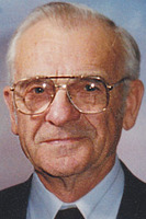
Fredrick Samuel Hall
| Birth | : | 5 Sep 1919 Miner County, South Dakota, USA |
| Death | : | 7 Oct 2009 Mitchell, Davison County, South Dakota, USA |
| Burial | : | Pollock Cemetery, Lewis County, USA |
| Coordinate | : | 35.4672012, -87.5006027 |
| Description | : | Fredrick Samuel Hall, 90, Howard, died Wednesday, Oct. 7, 2009, at Avera Queen of Peace Hospital, Mitchell. Funeral services were held Saturday at Beach United Methodist Church, Howard. Burial was in Fedora Cemetery, Fedora. He was born on Sept. 5, 1919, at home, on a farm south of Roswell, to William Earl and Essie Calista (Mather) Hall. He graduated from Argonne High School in 1938 and then stayed home to help on the farm. In May 1942, he enlisted in the U.S. Army during World War II. He served for four years, mostly... Read More |
frequently asked questions (FAQ):
-
Where is Fredrick Samuel Hall's memorial?
Fredrick Samuel Hall's memorial is located at: Pollock Cemetery, Lewis County, USA.
-
When did Fredrick Samuel Hall death?
Fredrick Samuel Hall death on 7 Oct 2009 in Mitchell, Davison County, South Dakota, USA
-
Where are the coordinates of the Fredrick Samuel Hall's memorial?
Latitude: 35.4672012
Longitude: -87.5006027
Family Members:
Parent
Siblings
Flowers:
Nearby Cemetories:
1. Pollock Cemetery
Lewis County, USA
Coordinate: 35.4672012, -87.5006027
2. Collier Cemetery
Lewis County, USA
Coordinate: 35.4606018, -87.5171967
3. Newtown Cemetery
Lewis County, USA
Coordinate: 35.4399986, -87.4906006
4. Napier Cemetery
Hohenwald, Lewis County, USA
Coordinate: 35.4403000, -87.4788971
5. Pope Cemetery
Lewis County, USA
Coordinate: 35.4646988, -87.5417023
6. Napier Cemetery
Lewis County, USA
Coordinate: 35.4367000, -87.4783000
7. Poore Cemetery
Lewis County, USA
Coordinate: 35.4874992, -87.5430984
8. Davis Cemetery
Lewis County, USA
Coordinate: 35.4564018, -87.5483017
9. Grinders Creek Cemetery
Lewis County, USA
Coordinate: 35.5099983, -87.4963989
10. Grinders Creek Cemetery
Lewis County, USA
Coordinate: 35.4944000, -87.5438995
11. Dirtdobber Cemetery
Lewis County, USA
Coordinate: 35.4296989, -87.5327988
12. Voorhies Cemetery
Lewis County, USA
Coordinate: 35.4413986, -87.5496979
13. Bailey Cemetery
Lewis County, USA
Coordinate: 35.4193993, -87.5152969
14. Freedom Holy Temple Cemetery
Hohenwald, Lewis County, USA
Coordinate: 35.5015340, -87.5482810
15. Himes Cemetery
Lewis County, USA
Coordinate: 35.4925003, -87.4443970
16. Pioneer Cemetery
Hohenwald, Lewis County, USA
Coordinate: 35.5107994, -87.4606018
17. Wright Cemetery
Lewis County, USA
Coordinate: 35.5208015, -87.4803009
18. Crowell Cemetery
Lewis County, USA
Coordinate: 35.4791985, -87.5714035
19. Springer Cemetery
Lewis County, USA
Coordinate: 35.5278015, -87.4888992
20. Lewis County Memorial Gardens
Hohenwald, Lewis County, USA
Coordinate: 35.5361700, -87.5221900
21. Laurel Hill Cemetery
Lawrence County, USA
Coordinate: 35.3939018, -87.5156021
22. Voorhies Cemetery
Lewis County, USA
Coordinate: 35.4655991, -87.5922012
23. Mannie Cemetery
Lewis County, USA
Coordinate: 35.4328003, -87.5875015
24. Banks Cemetery
Hohenwald, Lewis County, USA
Coordinate: 35.4486008, -87.5947037


