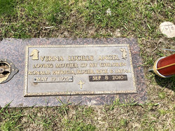
Freida Maxine Lowe Rezab
| Birth | : | 30 Jan 1926 Mason City, Cerro Gordo County, Iowa, USA |
| Death | : | 13 Nov 2010 Mason City, Cerro Gordo County, Iowa, USA |
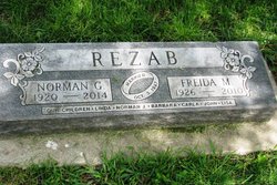
| Burial | : | Bohemian Cemetery, Plymouth, Cerro Gordo County, USA |
| Coordinate | : | 43.2522011, -93.1252975 |
| Plot | : | SE quadrant, Block 3, Lot 44, W 1/2 |
| Inscription | : | Married Oct 3, 1947 Our children Linda, Norman J, Barbara, Carla, John, Lisa |
| Description | : | Mother of six ============================= Freida Maxine (Lowe) Rezab, 84, of Mason City, Iowa and formerly of Plymouth, Iowa, died November 13, 2010 at the Heritage Care and Rehab Center in Mason City. Freida Maxine Rezab was born on January 30, 1926 in Mason City to Charles Cecil Lowe and Cleo Anna* (Amsbough) Lowe. On October 3, 1947 she was united in marriage to Norman Rezab, in Mason City, and to this union six children were born. Family was very important to Freida. She enjoyed gathering the entire family for holidays and fixing a meal for everyone to enjoy. She was especially known for... Read More |
frequently asked questions (FAQ):
-
Where is Freida Maxine Lowe Rezab's memorial?
Freida Maxine Lowe Rezab's memorial is located at: Bohemian Cemetery, Plymouth, Cerro Gordo County, USA.
-
When did Freida Maxine Lowe Rezab death?
Freida Maxine Lowe Rezab death on 13 Nov 2010 in Mason City, Cerro Gordo County, Iowa, USA
-
Where are the coordinates of the Freida Maxine Lowe Rezab's memorial?
Latitude: 43.2522011
Longitude: -93.1252975
Family Members:
Parent
Spouse
Siblings
Children
Flowers:
Nearby Cemetories:
1. Bohemian Cemetery
Plymouth, Cerro Gordo County, USA
Coordinate: 43.2522011, -93.1252975
2. Oakwood Cemetery
Plymouth, Cerro Gordo County, USA
Coordinate: 43.2538986, -93.1252975
3. Freddie Hensel Burial Site
Plymouth Junction, Cerro Gordo County, USA
Coordinate: 43.2827034, -93.1317902
4. Rock Falls Cemetery
Rock Falls, Cerro Gordo County, USA
Coordinate: 43.2122192, -93.0858307
5. Manly Cemetery
Manly, Worth County, USA
Coordinate: 43.2905617, -93.1999969
6. Sacred Heart Catholic Church Cemetery
Manly, Worth County, USA
Coordinate: 43.2911110, -93.2013931
7. Grafton Cemetery
Grafton, Worth County, USA
Coordinate: 43.3252983, -93.0631027
8. Emmanuel Lutheran Cemetery
Grafton, Worth County, USA
Coordinate: 43.3300018, -93.0691681
9. Saint Johns Episcopal Church Columbarium
Mason City, Cerro Gordo County, USA
Coordinate: 43.1528900, -93.1980730
10. First Congregational UCC Columbarium
Mason City, Cerro Gordo County, USA
Coordinate: 43.1529720, -93.1990410
11. Spring Grove Cemetery
Nora Springs, Floyd County, USA
Coordinate: 43.1631012, -93.0211029
12. Kensett Cemetery
Kensett, Worth County, USA
Coordinate: 43.3558006, -93.2003021
13. Saint Johns Lutheran Old Cemetery
Rock Creek, Mitchell County, USA
Coordinate: 43.3313904, -92.9897232
14. Elmwood Saint Joseph Cemetery
Mason City, Cerro Gordo County, USA
Coordinate: 43.1399994, -93.2067032
15. Saint Johns Lutheran Cemetery
Rock Creek, Mitchell County, USA
Coordinate: 43.3295560, -92.9849770
16. IOOF Cemetery
Mason City, Cerro Gordo County, USA
Coordinate: 43.1336975, -93.2139130
17. Park Cemetery
Nora Springs, Floyd County, USA
Coordinate: 43.1444016, -92.9982986
18. Elk Grove Cemetery
Kensett, Worth County, USA
Coordinate: 43.3581009, -93.2643967
19. Rock Creek Cemetery
Meroa, Mitchell County, USA
Coordinate: 43.2352791, -92.9225006
20. West End Cemetery
Meroa, Mitchell County, USA
Coordinate: 43.2216682, -92.9250031
21. Lincoln Township Cemetery
Cerro Gordo County, USA
Coordinate: 43.2419014, -93.3460999
22. Eden Presbyterian Cemetery
Meroa, Mitchell County, USA
Coordinate: 43.2131004, -92.9103012
23. Memorial Park Cemetery
Mason City, Cerro Gordo County, USA
Coordinate: 43.1469002, -93.2936020
24. Rock Grove Township Cemetery
Nora Springs, Floyd County, USA
Coordinate: 43.1227989, -92.9880981


