
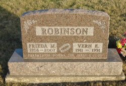
Frieda M. Stott Robinson
| Birth | : | 5 Jan 1914 Scotland County, Missouri, USA |
| Death | : | 10 Oct 2007 Arvada, Jefferson County, Colorado, USA |
| Burial | : | Danby Cemetery, Danby Township, Ionia County, USA |
| Coordinate | : | 42.7989006, -84.8983002 |
| Description | : | Frieda M. Robinson, 93, formerly of Keosauqua, IA, died October 10, 2007, at her home in Arvada, CO. She was born January 5, 1914, in rural Scotland County, MO, to John and Elsie Barnett Stott. She married Vern E. Robinson April 6, 1933 in Memphis, MO. He died October 21, 1991. She graduated from Cantril High School, lived most of her life in Cantril and Keosauqua, IA, and moved to Colorado to be near her children in 2004. She worked many years as a cook at Van Buren Community School, Keosauqua, IA, was an active member of Keosauqua Christian Church for over 70... Read More |
frequently asked questions (FAQ):
-
Where is Frieda M. Stott Robinson's memorial?
Frieda M. Stott Robinson's memorial is located at: Danby Cemetery, Danby Township, Ionia County, USA.
-
When did Frieda M. Stott Robinson death?
Frieda M. Stott Robinson death on 10 Oct 2007 in Arvada, Jefferson County, Colorado, USA
-
Where are the coordinates of the Frieda M. Stott Robinson's memorial?
Latitude: 42.7989006
Longitude: -84.8983002
Family Members:
Parent
Spouse

Flowers:


Nearby Cemetories:
1. Danby Cemetery
Danby Township, Ionia County, USA
Coordinate: 42.7989006, -84.8983002
2. Shimnecon Cemetery
Portland, Ionia County, USA
Coordinate: 42.8055220, -84.9070270
3. Ingalls Gravesite
Sebewa Corners, Ionia County, USA
Coordinate: 42.7925000, -84.9574500
4. Meadowbrook Cemetery
Mulliken, Eaton County, USA
Coordinate: 42.7550011, -84.9028015
5. East Sebewa Cemetery
Sebewa Township, Ionia County, USA
Coordinate: 42.8133011, -84.9608002
6. Portland Cemetery
Portland, Ionia County, USA
Coordinate: 42.8652860, -84.8953650
7. Union Cemetery
Grand Ledge, Eaton County, USA
Coordinate: 42.7670050, -84.8187450
8. North Eagle Cemetery
Eagle Township, Clinton County, USA
Coordinate: 42.8396988, -84.7956009
9. Matthew Cemetery
Ionia, Ionia County, USA
Coordinate: 42.8643990, -84.9953003
10. Sunfield Cemetery
Sunfield, Eaton County, USA
Coordinate: 42.7277985, -84.9907990
11. Eddy Family Cemetery
Eagle, Clinton County, USA
Coordinate: 42.8287100, -84.7691800
12. Welch Cemetery
Sunfield, Eaton County, USA
Coordinate: 42.7174988, -84.9766998
13. Moyer Cemetery
Roxand Township, Eaton County, USA
Coordinate: 42.6919160, -84.8958020
14. Union Cemetery
Portland, Ionia County, USA
Coordinate: 42.8991930, -84.9559020
15. Niles Cemetery
Eagle, Clinton County, USA
Coordinate: 42.8121986, -84.7497025
16. West Sebewa Cemetery
Lake Odessa, Ionia County, USA
Coordinate: 42.7995490, -85.0556050
17. Needmore Cemetery
Needmore, Eaton County, USA
Coordinate: 42.6829010, -84.8430130
18. Oakwood Cemetery
Grand Ledge, Eaton County, USA
Coordinate: 42.7566986, -84.7332993
19. Immanuel Lutheran Memorial Garden
Grand Ledge, Eaton County, USA
Coordinate: 42.7436580, -84.7388540
20. Horrocks Family Farm Cemetery
Lyons, Ionia County, USA
Coordinate: 42.9296950, -84.9169710
21. Freemire Cemetery
Sunfield, Eaton County, USA
Coordinate: 42.6852989, -84.9961014
22. Strange Cemetery
Grand Ledge, Eaton County, USA
Coordinate: 42.6952800, -84.7783300
23. Saint Marys Cemetery
Westphalia, Clinton County, USA
Coordinate: 42.9277992, -84.8116989
24. Keefer Cemetery
Orange Township, Ionia County, USA
Coordinate: 42.9364014, -84.9567032