
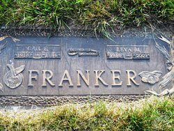
Gail Earle Franker
| Birth | : | 29 Oct 1918 Moneta, O'Brien County, Iowa, USA |
| Death | : | 6 Jul 1984 Royal, Clay County, Iowa, USA |
| Burial | : | North Lawn Cemetery, Spencer, Clay County, USA |
| Coordinate | : | 43.1600000, -95.1470000 |
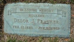
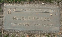
| Description | : | Son of Delor Joseph Franker and Mable Florence Demars ~~~ (Sutherland Courier Sutherland, O'Brien co., Iowa January 17, 1908 - Adelard Franker of Clay county and Miss Mabel DeMars of Grant township were married Wednesday morning in Sutherland by Rev. R. M. LeClair, pastor of Sacred Heart Church) Husband of Leva Maureen Beck Married Aug. 3, 1938 Iowa, State Census Collection, 1836-1925 Census Date: 1 Jan 1925 Residence County: Clay ✿ Delor Franker 41 ✿ Mabel Franker 33 ✿ Milvin Franker 16 ✿ Othel Franker 14 ✿ Bernard Franker 13 ✿ Gale Franker 6 ✿ Leola Franker 2 |
frequently asked questions (FAQ):
-
Where is Gail Earle Franker's memorial?
Gail Earle Franker's memorial is located at: North Lawn Cemetery, Spencer, Clay County, USA.
-
When did Gail Earle Franker death?
Gail Earle Franker death on 6 Jul 1984 in Royal, Clay County, Iowa, USA
-
Where are the coordinates of the Gail Earle Franker's memorial?
Latitude: 43.1600000
Longitude: -95.1470000
Family Members:
Parent
Spouse
Siblings

Children
Flowers:


Nearby Cemetories:
1. North Lawn Cemetery
Spencer, Clay County, USA
Coordinate: 43.1600000, -95.1470000
2. Dewey Readmore Books Memorial
Spencer, Clay County, USA
Coordinate: 43.1403999, -95.1443024
3. Riverside Cemetery
Spencer, Clay County, USA
Coordinate: 43.1441994, -95.1671982
4. Fairview Cemetery
Clay County, USA
Coordinate: 43.1899986, -95.0800018
5. Evergreen Cemetery
Clay County, USA
Coordinate: 43.2052994, -95.2086029
6. Dickens Cemetery
Dickens, Clay County, USA
Coordinate: 43.1280000, -95.0155000
7. Swedish Lutheran Cemetery
Royal, Clay County, USA
Coordinate: 43.0683000, -95.2350000
8. Little Sioux Lutheran Cemetery
Milford, Dickinson County, USA
Coordinate: 43.2702065, -95.2109528
9. Rosehill Cemetery
Clay County, USA
Coordinate: 43.0368996, -95.0919037
10. First Reformed Cemetery
Clay County, USA
Coordinate: 43.2399500, -95.2889000
11. Lone Tree Cemetery
Everly, Clay County, USA
Coordinate: 43.1411018, -95.3347015
12. Milford Cemetery
Milford, Dickinson County, USA
Coordinate: 43.3092003, -95.1481018
13. Lincoln Cemetery
Rossie, Clay County, USA
Coordinate: 43.0111008, -95.2313995
14. Calvary Cemetery
Milford, Dickinson County, USA
Coordinate: 43.3213997, -95.1688995
15. Logan Township Cemetery
Clay County, USA
Coordinate: 43.0489006, -94.9747009
16. Liberty Cemetery
Greenville, Clay County, USA
Coordinate: 42.9897003, -95.1417007
17. Willow Creek Cemetery
Royal, Clay County, USA
Coordinate: 43.0214005, -95.2885971
18. Clay Center Cemetery
Royal, Clay County, USA
Coordinate: 43.0410995, -95.3272018
19. TriMello Cemetery
Royal, Clay County, USA
Coordinate: 43.0682983, -95.3728027
20. Crown Hill Cemetery
Ruthven, Palo Alto County, USA
Coordinate: 43.1328011, -94.8878021
21. Calvary Cemetery
Ruthven, Palo Alto County, USA
Coordinate: 43.1314011, -94.8869019
22. Zion Methodist Cemetery
Clay County, USA
Coordinate: 42.9808006, -95.2497025
23. Westport Cemetery
Dickinson County, USA
Coordinate: 43.3130989, -95.3289032
24. Okoboji Cemetery
Arnolds Park, Dickinson County, USA
Coordinate: 43.3649406, -95.1303558