
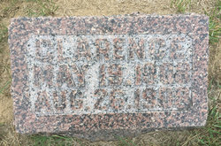
Gaily Hope Felker Reprogle
| Birth | : | 7 Aug 1889 Headlee, White County, Indiana, USA |
| Death | : | 20 Jun 1969 Lafayette, Tippecanoe County, Indiana, USA |
| Burial | : | Tracy Public Cemetery, Tracy, San Joaquin County, USA |
| Coordinate | : | 37.7251358, -121.4189453 |
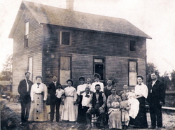
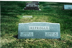
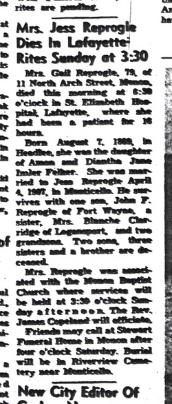
| Description | : | OBITUARY Mrs. Gail Reprogle,79, of 11 North Arch Street, Monon, died this ornig at 6:30 o'clock in St. Elizabeth Hospital, Lafayette, where she had been a patient for 16 hours. Born August 7, 1889, in Headlee, she was the daughter of Amon and Diantha Jane Imler Felker. She ws married to Jess Reprogle, April 4, 1907, in Monticello. He survives with one son, John F. Reprogle of Fort Wayne, a sister, Mrs. Blanche Claridge of Logansport, and two grandsons. Two sons, three sisters and a brother are deceased. Mrs. Reprogle was associated with the Monon Baptist Church where services will... Read More |
frequently asked questions (FAQ):
-
Where is Gaily Hope Felker Reprogle's memorial?
Gaily Hope Felker Reprogle's memorial is located at: Tracy Public Cemetery, Tracy, San Joaquin County, USA.
-
When did Gaily Hope Felker Reprogle death?
Gaily Hope Felker Reprogle death on 20 Jun 1969 in Lafayette, Tippecanoe County, Indiana, USA
-
Where are the coordinates of the Gaily Hope Felker Reprogle's memorial?
Latitude: 37.7251358
Longitude: -121.4189453
Family Members:
Parent
Spouse
Siblings
Children
Flowers:


Nearby Cemetories:
1. Tracy Public Cemetery
Tracy, San Joaquin County, USA
Coordinate: 37.7251358, -121.4189453
2. Tracy Mausoleum
Tracy, San Joaquin County, USA
Coordinate: 37.7250214, -121.4150696
3. Valpico Memorial Park
Tracy, San Joaquin County, USA
Coordinate: 37.7113260, -121.4656510
4. Brichetto Tomb
San Joaquin County, USA
Coordinate: 37.6272011, -121.3871994
5. East Union Cemetery
Manteca, San Joaquin County, USA
Coordinate: 37.8114014, -121.2350006
6. Congregation of Ahavas Achim Cemetery
French Camp, San Joaquin County, USA
Coordinate: 37.8778419, -121.2753067
7. Chinese Cemetery
French Camp, San Joaquin County, USA
Coordinate: 37.8819962, -121.2805862
8. Congregation Adas Yeshuran of Stockton Cemetery
French Camp, San Joaquin County, USA
Coordinate: 37.8784065, -121.2740784
9. Park View Cemetery
Manteca, San Joaquin County, USA
Coordinate: 37.8617249, -121.2238312
10. Five Pillars Farm Cemetery
Livermore, Alameda County, USA
Coordinate: 37.7262764, -121.7105789
11. Ripon Cemetery
Ripon, San Joaquin County, USA
Coordinate: 37.7420311, -121.1238708
12. Atlanta Cemetery
Five Corners, San Joaquin County, USA
Coordinate: 37.8270035, -121.1420135
13. Grayson Cemetery
Grayson, Stanislaus County, USA
Coordinate: 37.5594559, -121.1802826
14. Thomas Lindsay Gravesite
San Joaquin County, USA
Coordinate: 37.9573110, -121.2918430
15. David Kelsey Gravesite
Stockton, San Joaquin County, USA
Coordinate: 37.9573110, -121.2918430
16. Citizens Cemetery
Stockton, San Joaquin County, USA
Coordinate: 37.9559410, -121.2769120
17. Union Cemetery
Brentwood, Contra Costa County, USA
Coordinate: 37.9103012, -121.6477966
18. Temple Israel Cemetery
Stockton, San Joaquin County, USA
Coordinate: 37.9640541, -121.2784348
19. Stockton State Hospital Cemetery
Stockton, San Joaquin County, USA
Coordinate: 37.9663110, -121.2846850
20. Saint Michaels Cemetery
Livermore, Alameda County, USA
Coordinate: 37.6797790, -121.7519150
21. San Joaquin Catholic Cemetery
Stockton, San Joaquin County, USA
Coordinate: 37.9707830, -121.2850190
22. IOOF Memory Gardens Cemetery
Livermore, Alameda County, USA
Coordinate: 37.6797850, -121.7526100
23. Casa Bonita Mausoleum
Stockton, San Joaquin County, USA
Coordinate: 37.9752340, -121.2877800
24. Stockton Woodland Mausoleum
Stockton, San Joaquin County, USA
Coordinate: 37.9762400, -121.2878000