
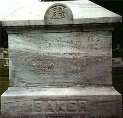
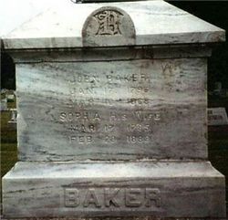
Gen John Baker
| Birth | : | 16 Jan 1796 Waterville, Kennebec County, Maine, USA |
| Death | : | 10 Mar 1868 Fort Kent, Aroostook County, Maine, USA |
| Burial | : | Riverside Cemetery, Fort Fairfield, Aroostook County, USA |
| Coordinate | : | 46.7750015, -67.8060989 |
| Plot | : | 756 |
| Description | : | Buried on removal Aug 15, 1895. Record does not state original burial place, however local newspaper says his body was moved from Fort Kent, ME. ========= Under His Own Flag: John Baker's Gravestone Memorial in Retrospect by: George L. Findlen webpage: https://digitalcommons.library.umaine.edu/cgi/viewcontent.cgi?article=1179&context=mainehistoryjournal The Upper St. John River Valley: John Baker webpage: https://www.upperstjohn.com/people/johnbaker.htm |
frequently asked questions (FAQ):
-
Where is Gen John Baker's memorial?
Gen John Baker's memorial is located at: Riverside Cemetery, Fort Fairfield, Aroostook County, USA.
-
When did Gen John Baker death?
Gen John Baker death on 10 Mar 1868 in Fort Kent, Aroostook County, Maine, USA
-
Where are the coordinates of the Gen John Baker's memorial?
Latitude: 46.7750015
Longitude: -67.8060989
Family Members:
Parent

Spouse
Siblings
Children
Flowers:


Nearby Cemetories:
1. Riverside Cemetery
Fort Fairfield, Aroostook County, USA
Coordinate: 46.7750015, -67.8060989
2. Saint Denis Catholic Cemetery
Fort Fairfield, Aroostook County, USA
Coordinate: 46.7773440, -67.8355030
3. Harvey Hill Cemetery
McShea, Aroostook County, USA
Coordinate: 46.7567099, -67.8652997
4. Union Cemetery
Fort Fairfield, Aroostook County, USA
Coordinate: 46.7566150, -67.8655240
5. Our Lady of Mercy Cemetery
Aroostook, Victoria County, Canada
Coordinate: 46.7977210, -67.7263700
6. Haines Maple Grove Cemetery
Fort Fairfield, Aroostook County, USA
Coordinate: 46.7233160, -67.8699040
7. Saint Ann Parish - Tobique First Nation Cemetery
Tobique, Victoria County, Canada
Coordinate: 46.7692510, -67.7055300
8. St. John The Evangelist Anglican Cemetery
Four Falls, Victoria County, Canada
Coordinate: 46.8278880, -67.7366425
9. Saint Mary of the Angels
Perth-Andover, Victoria County, Canada
Coordinate: 46.7607665, -67.7018074
10. Presbyterian Rural Cemetery
Perth-Andover, Victoria County, Canada
Coordinate: 46.7600894, -67.7013150
11. Wark Cemetery
Perth-Andover, Victoria County, Canada
Coordinate: 46.7286569, -67.7205736
12. Trinity Anglican Church Cemetery
Perth-Andover, Victoria County, Canada
Coordinate: 46.7571174, -67.6990229
13. Hillcrest Cemetery
Perth-Andover, Victoria County, Canada
Coordinate: 46.7431800, -67.7044100
14. Old Methodist Church Cemetery
Perth-Andover, Victoria County, Canada
Coordinate: 46.7506500, -67.6967900
15. Perth-Andover Baptist Church Cemetery
Perth-Andover, Victoria County, Canada
Coordinate: 46.7478522, -67.6969303
16. Larlee Creek Cemetery
Perth-Andover, Victoria County, Canada
Coordinate: 46.7147700, -67.7183500
17. Greenridge Cemetery
Caribou, Aroostook County, USA
Coordinate: 46.7923622, -67.9321976
18. Old Langley Cemetery
California Settlement, Victoria County, Canada
Coordinate: 46.8671210, -67.7631380
19. Knight Cemetery
Fort Fairfield, Aroostook County, USA
Coordinate: 46.6876150, -67.8778140
20. Kenneson Cemetery
Limestone, Aroostook County, USA
Coordinate: 46.8797900, -67.8047921
21. Bean Family Cemetery
Aroostook County, USA
Coordinate: 46.7396440, -67.9542600
22. Pine Tree Cemetery
Easton, Aroostook County, USA
Coordinate: 46.6774640, -67.8727940
23. Currie Cemetery
North Tilley, Victoria County, Canada
Coordinate: 46.8491850, -67.6886480
24. Beaconsfield Baptist Church Cemetery
Beaconsfield, Victoria County, Canada
Coordinate: 46.6640360, -67.7803850