
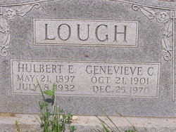

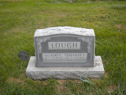
Genevieve Clara Pence Lough Bales
| Birth | : | 21 Oct 1901 Davis County, Iowa, USA |
| Death | : | 25 Dec 1970 Davis County, Iowa, USA |
| Burial | : | Honeyborough Cemetery, Wales |
| Coordinate | : | 51.7181200, -4.9595000 |
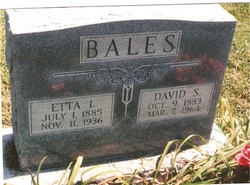
| Description | : | Mrs Genevieve Clara Bales, 69, widow of D S Bales, died at 3:40 a.m., Friday, at Davis County Hospital. She was the daughter of Giles and Phena Rayburn Pence, born in Davis County, Oct. 21, 1901. She was a lifelong county resident and a member of Dunnville Baptist Church. She was first married to Hulbert Lough in 1919. He died in 1932. She later married D S Bales in 1938. He died in 1964. Surviving are her father, Giles Pence of Bloomfield; three daughters, Mrs Sylvia Lawson of Bloomfield, Mrs Lee Etta Kinder in Illinois and Betty Williams of Newton;... Read More |
frequently asked questions (FAQ):
-
Where is Genevieve Clara Pence Lough Bales's memorial?
Genevieve Clara Pence Lough Bales's memorial is located at: Honeyborough Cemetery, Wales.
-
When did Genevieve Clara Pence Lough Bales death?
Genevieve Clara Pence Lough Bales death on 25 Dec 1970 in Davis County, Iowa, USA
-
Where are the coordinates of the Genevieve Clara Pence Lough Bales's memorial?
Latitude: 51.7181200
Longitude: -4.9595000
Family Members:
Parent

Spouse
Siblings
Children
Flowers:


Nearby Cemetories:
1. Honeyborough Cemetery
Wales
Coordinate: 51.7181200, -4.9595000
2. Monkton Cemetery
Wales
Coordinate: 51.6732100, -4.9282500
3. St. Cynllo Cemetery
Wales
Coordinate: 52.0813422, -4.6277205
4. Maes y Bont
Wales
Coordinate: 51.8324324, -4.0821915
5. Three Crosses Churchyard, Capel y Crwys
Wales
Coordinate: 51.6278387, -4.0653017
6. Wern Chapel
Wales
Coordinate: 52.2065510, -4.3272120
7. Rhyd-Y-Fro Saron Congregational Old Chapelyard
Wales
Coordinate: 51.7379400, -3.8662700
8. Alltwen Welsh Congregational Chapelyard
Wales
Coordinate: 51.7139600, -3.8444700
9. Godre'r Graig Independent Chapel Cemetery
Wales
Coordinate: 51.7474400, -3.8089300
10. St David Church Burial Ground
Wales
Coordinate: 51.7703100, -3.7884600
11. St Philip & St James
Ilfracombe, North Devon District, England
Coordinate: 51.2104300, -4.1175800
12. Marlborough Road Cemetery
Ilfracombe, North Devon District, England
Coordinate: 51.2017950, -4.1153670
13. Croyde Baptist Churchyard
Croyde, North Devon District, England
Coordinate: 51.1304140, -4.2156650
14. Georgeham Cemetery
Georgeham, North Devon District, England
Coordinate: 51.1420480, -4.1903960
15. St. George's Churchyard
Georgeham, North Devon District, England
Coordinate: 51.1376260, -4.1957130
16. St. Peter's Churchyard
Berrynarbor, North Devon District, England
Coordinate: 51.2013280, -4.0620470
17. St. Anne's Chapel
Saunton, North Devon District, England
Coordinate: 51.1177300, -4.2057100
18. Llandingat Parish Church
Wales
Coordinate: 51.9914392, -3.8022458
19. West Down Churchyard
West Down, North Devon District, England
Coordinate: 51.1580690, -4.1228290
20. St Nectan Churchyard
Stoke, Torridge District, England
Coordinate: 50.9949510, -4.5165690
21. Hartland Abbey
Hartland, Torridge District, England
Coordinate: 50.9965700, -4.5086740
22. St. Peter's Churchyard
Combe Martin, North Devon District, England
Coordinate: 51.1982700, -4.0248300
23. St Brannock Churchyard
Braunton, North Devon District, England
Coordinate: 51.1129520, -4.1597840
24. Saint David's Churchyard
Wales
Coordinate: 51.8017440, -3.6967650