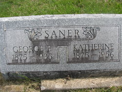
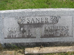
George Franklin Saner
| Birth | : | 22 May 1875 Bloomfield, Davis County, Iowa, USA |
| Death | : | 30 Dec 1935 Kirksville, Adair County, Missouri, USA |
| Burial | : | Massachusetts Veterans Memorial Cemetery, Winchendon, Worcester County, USA |
| Coordinate | : | 42.6851300, -72.0185200 |
| Description | : | married, son of John Saner and Elizabeth Cassatt, husband of Katherine R. Saner d. cert 38455 Missouri Death Certificate News of the death of Frank Saner proved a shock to his many friends Monday morning. He had been reported ill the past few weeks but it was not generally known his condition was serious. Removed from his home about four o’clock Sunday to a Kirksville hospital for treatment, he lingered only until 12 when he passed away. Funeral services were conducted at the Lancaster Christian church Tuesday afternoon by Rev. P. M. Lind of Queen City, assisted by Rev. Robert Seath. Interment was... Read More |
frequently asked questions (FAQ):
-
Where is George Franklin Saner's memorial?
George Franklin Saner's memorial is located at: Massachusetts Veterans Memorial Cemetery, Winchendon, Worcester County, USA.
-
When did George Franklin Saner death?
George Franklin Saner death on 30 Dec 1935 in Kirksville, Adair County, Missouri, USA
-
Where are the coordinates of the George Franklin Saner's memorial?
Latitude: 42.6851300
Longitude: -72.0185200
Family Members:
Parent
Spouse
Siblings
Children
Flowers:
Nearby Cemetories:
1. Massachusetts Veterans Memorial Cemetery
Winchendon, Worcester County, USA
Coordinate: 42.6851300, -72.0185200
2. Riverside Cemetery
Winchendon, Worcester County, USA
Coordinate: 42.6805992, -72.0263977
3. Calvary Cemetery
Winchendon, Worcester County, USA
Coordinate: 42.6805992, -72.0318985
4. Old Centre Burial Ground
Winchendon, Worcester County, USA
Coordinate: 42.6617012, -72.0366974
5. Robbins Cemetery
Rindge, Cheshire County, USA
Coordinate: 42.7266670, -72.0638890
6. Robbins Burial Ground
Rindge, Cheshire County, USA
Coordinate: 42.7268982, -72.0658035
7. Rand Cemetery
Rindge, Cheshire County, USA
Coordinate: 42.7350006, -72.0582962
8. Hillside Cemetery
Rindge, Cheshire County, USA
Coordinate: 42.7463000, -72.0063900
9. Wood Family Cemetery
Rindge, Cheshire County, USA
Coordinate: 42.7457040, -71.9859410
10. Meeting House Cemetery
Rindge, Cheshire County, USA
Coordinate: 42.7501200, -72.0096700
11. New Boston Cemetery
Winchendon, Worcester County, USA
Coordinate: 42.6306000, -72.0860977
12. Wilder Cemetery
Rindge, Cheshire County, USA
Coordinate: 42.7395400, -71.9404900
13. Greenlawn Cemetery
Templeton, Worcester County, USA
Coordinate: 42.6124992, -72.0708008
14. Meetinghouse Hill Cemetery
Ashburnham, Worcester County, USA
Coordinate: 42.6436900, -71.9176100
15. Fairbanks Cemetery
Ashburnham, Worcester County, USA
Coordinate: 42.6355220, -71.9236710
16. Cathedral of the Pines Cemetery
Rindge, Cheshire County, USA
Coordinate: 42.7749900, -71.9901800
17. New Cemetery
Ashburnham, Worcester County, USA
Coordinate: 42.6318400, -71.9137400
18. Saint Josephs Cemetery
Gardner, Worcester County, USA
Coordinate: 42.5922012, -72.0391998
19. Wildwood Cemetery
Gardner, Worcester County, USA
Coordinate: 42.5896988, -72.0306015
20. Saint Denis Cemetery
Ashburnham, Worcester County, USA
Coordinate: 42.6458015, -71.8985977
21. Saint Johns Cemetery
Gardner, Worcester County, USA
Coordinate: 42.5875015, -72.0207977
22. Notre Dame Cemetery
Gardner, Worcester County, USA
Coordinate: 42.5849991, -72.0222015
23. Crystal Lake Cemetery
Gardner, Worcester County, USA
Coordinate: 42.5833015, -71.9957962
24. Old Burying Ground
Gardner, Worcester County, USA
Coordinate: 42.5811800, -71.9867100


