

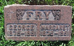
George Fry
| Birth | : | 9 Apr 1875 Ohio, USA |
| Death | : | 17 Aug 1951 Muscatine, Muscatine County, Iowa, USA |
| Burial | : | Sacred Heart Cemetery, Tularosa, Otero County, USA |
| Coordinate | : | 33.0809000, -106.0190000 |
| Plot | : | Lot 41, Space 4 |
| Description | : | George Fry, 76, Called in Death; Rites Monday George Fry, 76, custodian of the American Bank building for many years, died at midnight Friday [Aug 17 1951] at Bellevue hospital. He had been in failing health for about a year. The body was taken to the Riley Funeral home, where the Rosary will be recited at 8 o'clock Sunday evening. Funeral services will be conducted at 9 o'clock Monday morning at St. Mathias church with the Rev. J.J. Welsh in charge, and burial will be in the West Liberty Catholic cemetery. Mr. Fry was born... Read More |
frequently asked questions (FAQ):
-
Where is George Fry's memorial?
George Fry's memorial is located at: Sacred Heart Cemetery, Tularosa, Otero County, USA.
-
When did George Fry death?
George Fry death on 17 Aug 1951 in Muscatine, Muscatine County, Iowa, USA
-
Where are the coordinates of the George Fry's memorial?
Latitude: 33.0809000
Longitude: -106.0190000
Family Members:
Spouse
Children
Flowers:


Nearby Cemetories:
1. Fairview Cemetery
Tularosa, Otero County, USA
Coordinate: 33.0820740, -106.0194110
2. Our Lady of the Light Catholic Cemetery
La Luz, Otero County, USA
Coordinate: 32.9790340, -105.9500560
3. La Luz Community Cemetery
La Luz, Otero County, USA
Coordinate: 32.9789660, -105.9493910
4. Walters Cemetery
Otero County, USA
Coordinate: 33.1585999, -105.8563995
5. White Dove of the Desert Cemetery
Alamogordo, Otero County, USA
Coordinate: 32.9372770, -105.9419780
6. Little Chapel in the Desert Columbarium
Alamogordo, Otero County, USA
Coordinate: 32.9372670, -105.9419760
7. Our Lady of Guadalupe Cemetery
Bent, Otero County, USA
Coordinate: 33.1591970, -105.8546460
8. New Mexico Museum of Space History
Alamogordo, Otero County, USA
Coordinate: 32.9210610, -105.9206700
9. Saint Johns Columbarium
Alamogordo, Otero County, USA
Coordinate: 32.9015940, -105.9561990
10. Saint Jude Columbarium
Otero County, USA
Coordinate: 32.9055550, -105.9360150
11. Immaculate Conception Catholic Cemetery
Alamogordo, Otero County, USA
Coordinate: 32.8900909, -105.9457474
12. Monte Vista Cemetery
Alamogordo, Otero County, USA
Coordinate: 32.8901787, -105.9434662
13. Blazer Cemetery
Mescalero, Otero County, USA
Coordinate: 33.1567612, -105.7859573
14. Mescalero Indian Cemetery
Mescalero, Otero County, USA
Coordinate: 33.1474991, -105.7755966
15. Mountain Park Cemetery
Mountain Park, Otero County, USA
Coordinate: 32.9428680, -105.8144890
16. Saint Joseph Apache Mission Churchyard
Mescalero, Otero County, USA
Coordinate: 33.1548850, -105.7674670
17. Seven Graves Cemetery
Cloudcroft, Otero County, USA
Coordinate: 32.9623740, -105.7431120
18. Boles Acres Cemetery
Boles Acres, Otero County, USA
Coordinate: 32.8061390, -105.9850210
19. Santo Nino de Atocha Cemetery
Three Rivers, Otero County, USA
Coordinate: 33.3676380, -105.9613550
20. Bass Cemetery
Otero County, USA
Coordinate: 32.9060730, -105.6831340
21. Marcia Cemetery
Marcia, Otero County, USA
Coordinate: 32.8280556, -105.7552778
22. Baird Cemetery
Otero County, USA
Coordinate: 32.9542260, -105.6471740
23. James Canyon Cemetery
Mayhill, Otero County, USA
Coordinate: 32.9433000, -105.6194000
24. Parker Posey Cemetery
Cloudcroft, Otero County, USA
Coordinate: 32.9347380, -105.6054980