
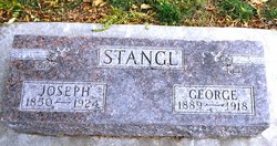
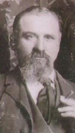
George John Stangl
| Birth | : | 7 Jul 1889 Carroll County, Iowa, USA |
| Death | : | 13 Nov 1918 Graettinger, Palo Alto County, Iowa, USA |
| Burial | : | Mount Olivet Cemetery, Carroll, Carroll County, USA |
| Coordinate | : | 42.0536340, -94.8595510 |
| Description | : | George was the son of Josef Stangl and Dorothea Halby. He married Elisabeth M Strunk (1893 IA, daughter of Mattis Strunk and Margaretha Amelia Spieker) on 10 January 1911 in Coon Rapids, Iowa. They were the parents of Clarence (1911), Mabel Mary (8-13-1913, Weatherman MO), and Irene (1916). Nov 14, 1918 - Carroll Times - George J. Stangl, a prominent young farmer of Sheridan township, was killed in an automobile accident at Graettinger, Iowa, Tuesday of this week. Details of the accident are lacking, but from the wording of a telegram received from the undertakers... Read More |
frequently asked questions (FAQ):
-
Where is George John Stangl's memorial?
George John Stangl's memorial is located at: Mount Olivet Cemetery, Carroll, Carroll County, USA.
-
When did George John Stangl death?
George John Stangl death on 13 Nov 1918 in Graettinger, Palo Alto County, Iowa, USA
-
Where are the coordinates of the George John Stangl's memorial?
Latitude: 42.0536340
Longitude: -94.8595510
Family Members:
Parent
Spouse
Siblings
Children
Flowers:


Nearby Cemetories:
1. Mount Olivet Cemetery
Carroll, Carroll County, USA
Coordinate: 42.0536340, -94.8595510
2. Carroll City Cemetery
Carroll, Carroll County, USA
Coordinate: 42.0560963, -94.8599856
3. Holy Angels Cemetery
Carroll County, USA
Coordinate: 42.0014000, -94.9141998
4. Saint Francis Cemetery
Maple River, Carroll County, USA
Coordinate: 42.0969009, -94.9372025
5. Saint Marys Catholic Cemetery
Willey, Carroll County, USA
Coordinate: 41.9783363, -94.8212204
6. Holy Family Cemetery
Lidderdale, Carroll County, USA
Coordinate: 42.1178017, -94.7839966
7. West Lawn Cemetery
Glidden, Carroll County, USA
Coordinate: 42.0649986, -94.7406006
8. Immanuel Cemetery
Lidderdale, Carroll County, USA
Coordinate: 42.1389008, -94.8022003
9. Saint Augustine Cemetery
Halbur, Carroll County, USA
Coordinate: 42.0066986, -94.9744034
10. Our Lady Of Mount Carmel Cemetery
Mount Carmel, Carroll County, USA
Coordinate: 42.1547012, -94.9088974
11. Arcadia Cemetery
Arcadia Township, Carroll County, USA
Coordinate: 42.1000680, -95.0130550
12. East Liberty Cemetery
Lidderdale, Carroll County, USA
Coordinate: 42.1591988, -94.7636032
13. McCurdy Cemetery
Carroll County, USA
Coordinate: 41.9403000, -94.7649994
14. Saint Johns Catholic Cemetery
Arcadia, Carroll County, USA
Coordinate: 42.0855406, -95.0341577
15. Dickson Cemetery
Glidden Township, Carroll County, USA
Coordinate: 42.1074982, -94.6939011
16. Saint Bernards Cemetery
Breda, Carroll County, USA
Coordinate: 42.1786003, -94.9732971
17. Elba Cemetery
Templeton, Carroll County, USA
Coordinate: 41.9068985, -94.9131012
18. Sacred Heart Cemetery
Templeton, Carroll County, USA
Coordinate: 41.9138746, -94.9460994
19. Dedham Cemetery
Dedham, Carroll County, USA
Coordinate: 41.8993988, -94.8225021
20. Saint Josephs Cemetery
Dedham, Carroll County, USA
Coordinate: 41.8993988, -94.8210983
21. North Coon Cemetery
Carroll County, USA
Coordinate: 42.1260986, -94.6716995
22. Old Carrollton Cemetery
Carrollton, Carroll County, USA
Coordinate: 41.9233017, -94.7403030
23. Lanesboro Cemetery
Lanesboro, Carroll County, USA
Coordinate: 42.1810989, -94.7230988
24. Luckow Cemetery
Auburn, Sac County, USA
Coordinate: 42.2168999, -94.9266968