George Michael Murr Sr.
| Birth | : | 30 Nov 1769 Salisbury, Rowan County, North Carolina, USA |
| Death | : | 11 Dec 1812 Salisbury, Rowan County, North Carolina, USA |
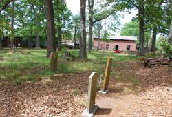
| Burial | : | Friends Cemetery, Richland, Keokuk County, USA |
| Coordinate | : | 41.1917000, -91.9953003 |
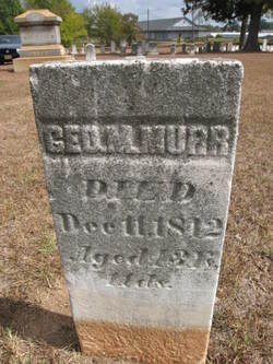
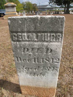
| Inscription | : | GEO. M. MURR Died: Dec 11, 1812 Aged: 43 years 11 days |
| Description | : | Son of Michael Murr (the potter) and Susannah ____ Murr George Michael Murr married Easter Earnhart 14 January 1789, Rowan County, North Carolina. Easter born 1765-70. Alive 1810 census. Possibly born 1 December 1768? Salisbury, North Carolina. He died 11 December 1812, 43 years, 11 days, Salisbury, North Carolina. Death date on stone. Buried in Salisbury, North Carolina, Lutheran Cemetery. 6 Children: 1. Dolly Murr born 1787, married Abraham Sharp, 14 September 1808, Concord, North Carolina. 2. Betsy Murr possibly born 1789, married Joseph Weant, 19 October 1808, Rowan County, North Carolina. 3. Easter Murr born 1793, married John Bruner, 21 May 1812, Rowan County, North... Read More |
frequently asked questions (FAQ):
-
Where is George Michael Murr Sr.'s memorial?
George Michael Murr Sr.'s memorial is located at: Friends Cemetery, Richland, Keokuk County, USA.
-
When did George Michael Murr Sr. death?
George Michael Murr Sr. death on 11 Dec 1812 in Salisbury, Rowan County, North Carolina, USA
-
Where are the coordinates of the George Michael Murr Sr.'s memorial?
Latitude: 41.1917000
Longitude: -91.9953003
Family Members:
Children
Nearby Cemetories:
1. Friends Cemetery
Richland, Keokuk County, USA
Coordinate: 41.1917000, -91.9953003
2. Highland Cemetery
Richland, Keokuk County, USA
Coordinate: 41.1949997, -91.9985962
3. Old Methodist Cemetery
Richland, Keokuk County, USA
Coordinate: 41.1948000, -92.0002000
4. Summit Cemetery
Richland, Keokuk County, USA
Coordinate: 41.1897011, -92.0291977
5. Blue Point Cemetery
Jefferson County, USA
Coordinate: 41.1618996, -92.0218964
6. Rocky Run Cemetery
Richland, Keokuk County, USA
Coordinate: 41.2055707, -91.9473964
7. Halferty Cemetery
Ollie, Keokuk County, USA
Coordinate: 41.1917000, -92.0539017
8. Reed Cemetery
Richland Township, Keokuk County, USA
Coordinate: 41.2355995, -92.0216980
9. Evergreen Cemetery
Rubio, Washington County, USA
Coordinate: 41.2139015, -91.9328003
10. Ollie Brethren Cemetery
Ollie, Keokuk County, USA
Coordinate: 41.2063782, -92.0632183
11. Clay Cemetery
Rubio, Washington County, USA
Coordinate: 41.1857986, -91.9218979
12. Howard Grove Cemetery
Jefferson County, USA
Coordinate: 41.1488991, -91.9419022
13. Altman Cemetery
Ollie, Keokuk County, USA
Coordinate: 41.1747017, -92.0733032
14. Laux Park Family Cemetery
Brighton, Washington County, USA
Coordinate: 41.1913920, -91.9098620
15. McDowell Cemetery
Fairfield, Jefferson County, USA
Coordinate: 41.1380997, -91.9460983
16. Ann Gowey Cemetery
Brighton, Washington County, USA
Coordinate: 41.1999642, -91.8974728
17. Ollie Cemetery
Ollie, Keokuk County, USA
Coordinate: 41.1988983, -92.1082993
18. Prairie Center Cemetery
Packwood, Jefferson County, USA
Coordinate: 41.1264000, -92.0849991
19. Valley Cemetery
Washington County, USA
Coordinate: 41.2729000, -91.9320000
20. Brater Cemetery
Lancaster, Keokuk County, USA
Coordinate: 41.2543000, -92.0928000
21. Moyer Cemetery
Fairfield, Jefferson County, USA
Coordinate: 41.1046982, -91.9330978
22. Oak Ridge Cemetery
Washington County, USA
Coordinate: 41.2574997, -91.8946991
23. White Oak Cemetery
Washington County, USA
Coordinate: 41.2578011, -91.8891983
24. Talleyrand Cemetery
Clear Creek Township, Keokuk County, USA
Coordinate: 41.2952995, -91.9710999


