
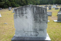
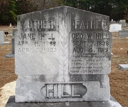
George W. Hill
| Birth | : | 7 Sep 1838 USA |
| Death | : | 4 Aug 1919 Antioch, Darlington County, South Carolina, USA |
| Burial | : | East Union Cemetery, Manteca, San Joaquin County, USA |
| Coordinate | : | 37.8114014, -121.2350006 |
| Description | : | Confirmed veteran. Company C Manigault's Artillery . He is buried at Antioch Cemetery in Darlington County, SC. |
frequently asked questions (FAQ):
-
Where is George W. Hill's memorial?
George W. Hill's memorial is located at: East Union Cemetery, Manteca, San Joaquin County, USA.
-
When did George W. Hill death?
George W. Hill death on 4 Aug 1919 in Antioch, Darlington County, South Carolina, USA
-
Where are the coordinates of the George W. Hill's memorial?
Latitude: 37.8114014
Longitude: -121.2350006
Family Members:
Spouse
Children


Nearby Cemetories:
1. Park View Cemetery
Manteca, San Joaquin County, USA
Coordinate: 37.8617249, -121.2238312
2. Congregation of Ahavas Achim Cemetery
French Camp, San Joaquin County, USA
Coordinate: 37.8778419, -121.2753067
3. Congregation Adas Yeshuran of Stockton Cemetery
French Camp, San Joaquin County, USA
Coordinate: 37.8784065, -121.2740784
4. Atlanta Cemetery
Five Corners, San Joaquin County, USA
Coordinate: 37.8270035, -121.1420135
5. Chinese Cemetery
French Camp, San Joaquin County, USA
Coordinate: 37.8819962, -121.2805862
6. Ripon Cemetery
Ripon, San Joaquin County, USA
Coordinate: 37.7420311, -121.1238708
7. Collegeville Cemetery
Collegeville, San Joaquin County, USA
Coordinate: 37.9044800, -121.1466141
8. Saint John's Catholic Cemetery
Escalon, San Joaquin County, USA
Coordinate: 37.7994537, -121.0705185
9. Citizens Cemetery
Stockton, San Joaquin County, USA
Coordinate: 37.9559410, -121.2769120
10. Thomas Lindsay Gravesite
San Joaquin County, USA
Coordinate: 37.9573110, -121.2918430
11. David Kelsey Gravesite
Stockton, San Joaquin County, USA
Coordinate: 37.9573110, -121.2918430
12. Temple Israel Cemetery
Stockton, San Joaquin County, USA
Coordinate: 37.9640541, -121.2784348
13. Stockton State Hospital Cemetery
Stockton, San Joaquin County, USA
Coordinate: 37.9663110, -121.2846850
14. San Joaquin Catholic Cemetery
Stockton, San Joaquin County, USA
Coordinate: 37.9707830, -121.2850190
15. Tracy Mausoleum
Tracy, San Joaquin County, USA
Coordinate: 37.7250214, -121.4150696
16. Casa Bonita Mausoleum
Stockton, San Joaquin County, USA
Coordinate: 37.9752340, -121.2877800
17. Tracy Public Cemetery
Tracy, San Joaquin County, USA
Coordinate: 37.7251358, -121.4189453
18. Stockton Woodland Mausoleum
Stockton, San Joaquin County, USA
Coordinate: 37.9762400, -121.2878000
19. Stockton Rural Cemetery
Stockton, San Joaquin County, USA
Coordinate: 37.9794006, -121.2869034
20. Wood Colony Cemetery
Salida, Stanislaus County, USA
Coordinate: 37.6893730, -121.0682144
21. Central United Methodist Church Columbarium
Stockton, San Joaquin County, USA
Coordinate: 37.9825710, -121.3078170
22. Good Shepherd Catholic Cemetery
Modesto, Stanislaus County, USA
Coordinate: 37.6853130, -121.0672890
23. Valpico Memorial Park
Tracy, San Joaquin County, USA
Coordinate: 37.7113260, -121.4656510
24. Highland View Memorial Gardens
Farmington, San Joaquin County, USA
Coordinate: 37.9242935, -121.0008621