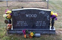
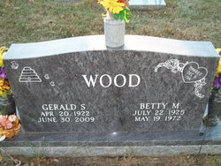
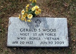
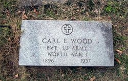
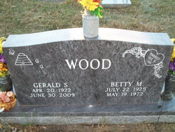
Gerald Stanford Wood
| Birth | : | 20 Apr 1922 Slater, Saline County, Missouri, USA |
| Death | : | 3 Jul 2009 Slater, Saline County, Missouri, USA |
| Burial | : | Lake Ripley Cemetery, Cambridge, Jefferson County, USA |
| Coordinate | : | 43.0041809, -89.0011673 |
| Description | : | Wednesday, July 1, 2009 Marshall Democrat-News Gerald S. Wood, 87, of Slater, died Tuesday, June 30, 2009, at his home. Funeral services will be held Friday, July 3, 2009, at 11 a.m. at First Baptist Church in Slater, with Rev. Robert Sisney will officiating. Bethany Weiker, organist, will play "Take My Hand, Precious Lord" and "It Is Well With My Soul." Burial will be in Rehoboth Cemetery. Pallbearers will be Donald Ray Durham, John Markovich, Bob Durham, Mike Huston, Ted Worley and Elisah Durham. Visitation will be held from 10 to 11 a.m. Friday at the church. Memorials... Read More |
frequently asked questions (FAQ):
-
Where is Gerald Stanford Wood's memorial?
Gerald Stanford Wood's memorial is located at: Lake Ripley Cemetery, Cambridge, Jefferson County, USA.
-
When did Gerald Stanford Wood death?
Gerald Stanford Wood death on 3 Jul 2009 in Slater, Saline County, Missouri, USA
-
Where are the coordinates of the Gerald Stanford Wood's memorial?
Latitude: 43.0041809
Longitude: -89.0011673
Family Members:
Parent
Spouse
Siblings
Flowers:
Nearby Cemetories:
1. Lake Ripley Cemetery
Cambridge, Jefferson County, USA
Coordinate: 43.0041809, -89.0011673
2. Willerup Methodist Cemetery
Cambridge, Dane County, USA
Coordinate: 43.0021019, -89.0225067
3. Saint Pius X Church Cemetery
Cambridge, Dane County, USA
Coordinate: 42.9997670, -89.0264230
4. Rockdale Lutheran Church Cemetery
Rockdale, Dane County, USA
Coordinate: 42.9733300, -89.0372200
5. Oakland Center Cemetery
Oakland, Jefferson County, USA
Coordinate: 42.9767200, -88.9532600
6. Hauge Cemetery
Deerfield, Dane County, USA
Coordinate: 43.0257988, -89.0744019
7. East Koshkonong Cemetery
Cambridge, Dane County, USA
Coordinate: 42.9530602, -89.0476500
8. Oakland Evergreen Cemetery
Oakland, Jefferson County, USA
Coordinate: 42.9533000, -88.9541300
9. Kroghville Cemetery
Kroghville, Jefferson County, USA
Coordinate: 43.0663800, -89.0069400
10. Gericke Cemetery
Kroghville, Jefferson County, USA
Coordinate: 43.0674930, -89.0115740
11. North Oakland Cemetery
Oakland, Jefferson County, USA
Coordinate: 43.0018997, -88.9088974
12. Oakland Seventh-Day Cemetery
Oakland, Jefferson County, USA
Coordinate: 42.9402100, -88.9689400
13. Pioneer Norwegian Cemetery
Albion, Dane County, USA
Coordinate: 42.9311120, -89.0429800
14. Saint Pauls Evangelical Lutheran Cemetery
Lake Mills, Jefferson County, USA
Coordinate: 43.0591800, -88.9218900
15. Deerfield Lutheran Cemetery
Deerfield, Dane County, USA
Coordinate: 43.0511100, -89.0966600
16. Saint Pauls Liberty Lutheran Cemetery
Deerfield, Dane County, USA
Coordinate: 43.0404396, -89.1073532
17. Ward Cemetery
Oakland, Jefferson County, USA
Coordinate: 42.9616680, -88.8955740
18. Taylor Family Cemetery
Fort Atkinson, Jefferson County, USA
Coordinate: 42.9476900, -88.9070320
19. Arity Family Cemetery
Fort Atkinson, Jefferson County, USA
Coordinate: 42.9787800, -88.8753600
20. Union Cemetery
Sumner, Jefferson County, USA
Coordinate: 42.9342003, -88.9085999
21. Saint Annes Catholic Cemetery
Deerfield, Dane County, USA
Coordinate: 43.0822200, -89.0827500
22. Albion Prairie Cemetery
Albion, Dane County, USA
Coordinate: 42.9131012, -89.0563965
23. Busseyville Cemetery
Busseyville, Jefferson County, USA
Coordinate: 42.9003800, -88.9829100
24. Liberty Prairie Cemetery
Nora, Dane County, USA
Coordinate: 43.0317001, -89.1397018

