

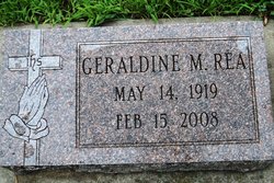
Geraldine Muzette “Jerri” Fansler Rea
| Birth | : | 14 May 1919 York County, Nebraska, USA |
| Death | : | 15 Feb 2008 York, York County, Nebraska, USA |
| Burial | : | White Hut Gaelic Cemetery, Clare, District Council of Clare and Gilbert Valleys, Australia |
| Coordinate | : | -33.8040010, 138.6283890 |
| Description | : | Geraldine Muzette (Fansler) Rea was born May 14, 1919 near Bradshaw, Nebraska to David Norton and Dora Victoria (Mason) Fansler and passsed away on February 15, 2008 in York, Nebraska at the age of 88 years. Jerri attended school in Benedict, Nebraska. On June 24, 1943 she was united in marriage to Thomas Edmund Rea in Lincoln, Nebraska. Their marriage was blessed with two sons, Thomas and David. Jerri and Tom moved to Seward in 1952, where they spent most of their married life. Jerri was a member of St. Vincent dePaul Catholic Church and Altar Society in Seward.... Read More |
frequently asked questions (FAQ):
-
Where is Geraldine Muzette “Jerri” Fansler Rea's memorial?
Geraldine Muzette “Jerri” Fansler Rea's memorial is located at: White Hut Gaelic Cemetery, Clare, District Council of Clare and Gilbert Valleys, Australia.
-
When did Geraldine Muzette “Jerri” Fansler Rea death?
Geraldine Muzette “Jerri” Fansler Rea death on 15 Feb 2008 in York, York County, Nebraska, USA
-
Where are the coordinates of the Geraldine Muzette “Jerri” Fansler Rea's memorial?
Latitude: -33.8040010
Longitude: 138.6283890
Family Members:
Parent
Spouse

Siblings

Flowers:


Nearby Cemetories:
1. White Hut Gaelic Cemetery
Clare, District Council of Clare and Gilbert Valleys, Australia
Coordinate: -33.8040010, 138.6283890
2. White Hut Cemetery
Stanley Flat, District Council of Clare and Gilbert Valleys, Australia
Coordinate: -33.7971650, 138.6234010
3. Stanley Flat Gaelic Cemetery
Clare, District Council of Clare and Gilbert Valleys, Australia
Coordinate: -33.7915580, 138.6066290
4. St. Barnabas Anglican Cemetery
Clare, District Council of Clare and Gilbert Valleys, Australia
Coordinate: -33.8301000, 138.6127000
5. Clare Presbyterian Cemetery
Clare, District Council of Clare and Gilbert Valleys, Australia
Coordinate: -33.8338460, 138.6156330
6. St. Michael's Catholic Cemetery
Clare, District Council of Clare and Gilbert Valleys, Australia
Coordinate: -33.8363060, 138.6096630
7. Clare General Cemetery
Clare, District Council of Clare and Gilbert Valleys, Australia
Coordinate: -33.8429900, 138.6016430
8. Clare Spring Farm Wesleyan Cemetery
Clare, District Council of Clare and Gilbert Valleys, Australia
Coordinate: -33.8630660, 138.6387190
9. St Michaels Anglican Church Cemetery
Bungaree, District Council of Clare and Gilbert Valleys, Australia
Coordinate: -33.7439580, 138.5616060
10. Sevenhill Cemetery
Sevenhill, District Council of Clare and Gilbert Valleys, Australia
Coordinate: -33.8861020, 138.6312260
11. Blyth Cemetery
Blyth, Wakefield Regional Council, Australia
Coordinate: -33.8261460, 138.4943480
12. St. Mark's Angelican Cemetery
Penwortham, District Council of Clare and Gilbert Valleys, Australia
Coordinate: -33.9214510, 138.6413830
13. Mintaro Catholic Cemetery
Mintaro, District Council of Clare and Gilbert Valleys, Australia
Coordinate: -33.9124530, 138.7194630
14. Farrell Flat Cemetery
Farrell Flats, Goyder Regional Council, Australia
Coordinate: -33.8249685, 138.7857266
15. Mintaro Cemetery
Mintaro, District Council of Clare and Gilbert Valleys, Australia
Coordinate: -33.9175520, 138.7164540
16. Kybunga Cemetery
Hoyleton, Wakefield Regional Council, Australia
Coordinate: -33.9202100, 138.5197360
17. Watervale Cemetery
Clare, District Council of Clare and Gilbert Valleys, Australia
Coordinate: -33.9678890, 138.6546991
18. Leasingham Upper Skilly Cemetery
Auburn, District Council of Clare and Gilbert Valleys, Australia
Coordinate: -33.9996690, 138.6179280
19. Angle Grove Cemetery
Brinkworth, Wakefield Regional Council, Australia
Coordinate: -33.6765530, 138.4376980
20. Springfield Cemetery
Williamstown, Barossa Council, Australia
Coordinate: -34.0000000, 138.5500000
21. St John’s Anglican Cemetery
Auburn, District Council of Clare and Gilbert Valleys, Australia
Coordinate: -34.0264310, 138.6835587
22. Black Springs Cemetery
Black Springs, District Council of Clare and Gilbert Valleys, Australia
Coordinate: -33.8884150, 138.8909940
23. Auburn Cemetery
Auburn, District Council of Clare and Gilbert Valleys, Australia
Coordinate: -34.0314560, 138.7036850
24. Manoora Catholic Cemetery
Manoora, District Council of Clare and Gilbert Valleys, Australia
Coordinate: -33.9911920, 138.8144040