| Birth | : | 9 Jun 1930 Alliance, Box Butte County, Nebraska, USA |
| Death | : | 18 Feb 2011 Fargo, Cass County, North Dakota, USA |
| Burial | : | Riverside Cemetery, Ironwood, Gogebic County, USA |
| Coordinate | : | 46.4599476, -90.1829530 |
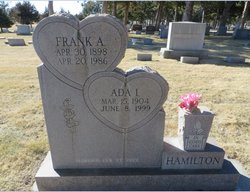
| Description | : | Gerold E. Hamilton 80 of rural Battle Lake, Minnesota went to be with his Lord and Saviour on February 18, 2011 in flight to Sanford Health Care in Fargo, North Dakota. Gerold Edwin Hamilton was born on June 29, 1930 in Alliance, Nebraska the son of Frank and Ada Iola (Speer) Hamilton. He was the fourth of eight children. Gerold was raised in the Sandhills south of Gordon, in a sod house on the family ranch. Years later the family moved to a new home built near the soddy's site. He attended country school through the eighth grade,... Read More |
frequently asked questions (FAQ):
-
Where is Gerold Edwin Hamilton's memorial?
Gerold Edwin Hamilton's memorial is located at: Riverside Cemetery, Ironwood, Gogebic County, USA.
-
When did Gerold Edwin Hamilton death?
Gerold Edwin Hamilton death on 18 Feb 2011 in Fargo, Cass County, North Dakota, USA
-
Where are the coordinates of the Gerold Edwin Hamilton's memorial?
Latitude: 46.4599476
Longitude: -90.1829530
Family Members:
Parent
Siblings
Flowers:
Nearby Cemetories:
1. Riverside Cemetery
Ironwood, Gogebic County, USA
Coordinate: 46.4599476, -90.1829530
2. Saint Mary's Cemetery
Hurley, Iron County, USA
Coordinate: 46.4443200, -90.1812600
3. Sharey Zedek Cemetery
Hurley, Iron County, USA
Coordinate: 46.4433280, -90.1824760
4. Hurley Cemetery
Hurley, Iron County, USA
Coordinate: 46.4429800, -90.1813800
5. Sunset Acres Cemetery
Ironwood, Gogebic County, USA
Coordinate: 46.5189490, -90.1660820
6. Hillcrest Cemetery
Bessemer, Gogebic County, USA
Coordinate: 46.4855995, -90.0456009
7. Hillside Cemetery
Iron Belt, Iron County, USA
Coordinate: 46.4000015, -90.3377991
8. Lakeside Cemetery
Wakefield, Gogebic County, USA
Coordinate: 46.4674988, -89.9456024
9. Lake View Cemetery
Saxon, Iron County, USA
Coordinate: 46.5010986, -90.4227982
10. Calvary Cemetery
Upson, Iron County, USA
Coordinate: 46.3774986, -90.4080963
11. Greenwood Cemetery
Upson, Iron County, USA
Coordinate: 46.3778000, -90.4094009
12. Indian Cemetery
Ironwood, Gogebic County, USA
Coordinate: 46.6058330, -90.3305560
13. Edgewood Cemetery
Gurney, Iron County, USA
Coordinate: 46.4972000, -90.5077972
14. Saint Johns Lutheran Cemetery
Mellen, Ashland County, USA
Coordinate: 46.3923800, -90.5690100
15. Mercer Cemetery
Mercer, Iron County, USA
Coordinate: 46.1575012, -90.0539017
16. Winchester Memorial Cemetery
Winchester, Vilas County, USA
Coordinate: 46.2452300, -89.8359900
17. Marenisco Township Cemetery
Marenisco, Gogebic County, USA
Coordinate: 46.3847220, -89.6969440
18. Mellen Union Cemetery
Mellen, Ashland County, USA
Coordinate: 46.3294800, -90.6621800
19. Presque Isle Cemetery
Presque Isle, Vilas County, USA
Coordinate: 46.2442017, -89.7624969
20. Shanty Boy Hill Cemetery
Presque Isle, Vilas County, USA
Coordinate: 46.2473520, -89.7279540
21. Mount Hope Cemetery
High Bridge, Ashland County, USA
Coordinate: 46.3859700, -90.7353300
22. Bad River Cemetery
Odanah, Ashland County, USA
Coordinate: 46.5992100, -90.7208900
23. Pine Lawn Cemetery
Manitowish Waters, Vilas County, USA
Coordinate: 46.1241250, -89.8659110
24. Greenwood Cemetery
Morse, Ashland County, USA
Coordinate: 46.2224846, -90.6509399


