
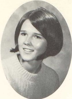


Getta Ernadene Radley Rumpza
| Birth | : | 5 Feb 1951 Spencer, Clay County, Iowa, USA |
| Death | : | 13 Jul 2002 Springfield, Greene County, Missouri, USA |
| Burial | : | Riverside Cemetery, Spencer, Clay County, USA |
| Coordinate | : | 43.1441994, -95.1671982 |
| Plot | : | Block:22 Lot:82 Space:7 |
| Description | : | Getta E Rumpza, the daughter of Ernest and Esther Nicholson Radley, was born February 5, 1951 in Spencer, Iowa. Her childhood years were spent in Spencer, where she received her education. Following her schooling, she remained in Spencer, where she worked in sales and collections for Northwestern Bell Telephone. Getta married Robert Rumpza on January 27, 1981 in Mt. Vernon, Missouri. Following their marriage, they moved to Tulsa, Oklahoma, where she continued to work for Northwestern Bell Telephone. In 1987, she retired and moved to Mt. Vernon, Missouri, where she helped her husband in the concrete business. She was a... Read More |
frequently asked questions (FAQ):
-
Where is Getta Ernadene Radley Rumpza's memorial?
Getta Ernadene Radley Rumpza's memorial is located at: Riverside Cemetery, Spencer, Clay County, USA.
-
When did Getta Ernadene Radley Rumpza death?
Getta Ernadene Radley Rumpza death on 13 Jul 2002 in Springfield, Greene County, Missouri, USA
-
Where are the coordinates of the Getta Ernadene Radley Rumpza's memorial?
Latitude: 43.1441994
Longitude: -95.1671982
Family Members:
Parent
Spouse
Flowers:


Nearby Cemetories:
1. Riverside Cemetery
Spencer, Clay County, USA
Coordinate: 43.1441994, -95.1671982
2. Dewey Readmore Books Memorial
Spencer, Clay County, USA
Coordinate: 43.1403999, -95.1443024
3. North Lawn Cemetery
Spencer, Clay County, USA
Coordinate: 43.1600000, -95.1470000
4. Evergreen Cemetery
Clay County, USA
Coordinate: 43.2052994, -95.2086029
5. Fairview Cemetery
Clay County, USA
Coordinate: 43.1899986, -95.0800018
6. Swedish Lutheran Cemetery
Royal, Clay County, USA
Coordinate: 43.0683000, -95.2350000
7. Dickens Cemetery
Dickens, Clay County, USA
Coordinate: 43.1280000, -95.0155000
8. Rosehill Cemetery
Clay County, USA
Coordinate: 43.0368996, -95.0919037
9. Lone Tree Cemetery
Everly, Clay County, USA
Coordinate: 43.1411018, -95.3347015
10. Little Sioux Lutheran Cemetery
Milford, Dickinson County, USA
Coordinate: 43.2702065, -95.2109528
11. First Reformed Cemetery
Clay County, USA
Coordinate: 43.2399500, -95.2889000
12. Lincoln Cemetery
Rossie, Clay County, USA
Coordinate: 43.0111008, -95.2313995
13. Willow Creek Cemetery
Royal, Clay County, USA
Coordinate: 43.0214005, -95.2885971
14. Liberty Cemetery
Greenville, Clay County, USA
Coordinate: 42.9897003, -95.1417007
15. Clay Center Cemetery
Royal, Clay County, USA
Coordinate: 43.0410995, -95.3272018
16. Milford Cemetery
Milford, Dickinson County, USA
Coordinate: 43.3092003, -95.1481018
17. TriMello Cemetery
Royal, Clay County, USA
Coordinate: 43.0682983, -95.3728027
18. Logan Township Cemetery
Clay County, USA
Coordinate: 43.0489006, -94.9747009
19. Zion Methodist Cemetery
Clay County, USA
Coordinate: 42.9808006, -95.2497025
20. Calvary Cemetery
Milford, Dickinson County, USA
Coordinate: 43.3213997, -95.1688995
21. Fanny Fern Cemetery
Clay County, USA
Coordinate: 42.9530983, -95.1607971
22. Crown Hill Cemetery
Ruthven, Palo Alto County, USA
Coordinate: 43.1328011, -94.8878021
23. Calvary Cemetery
Ruthven, Palo Alto County, USA
Coordinate: 43.1314011, -94.8869019
24. Westport Cemetery
Dickinson County, USA
Coordinate: 43.3130989, -95.3289032