
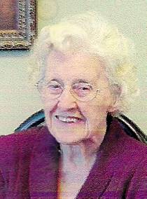
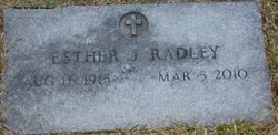
Esther Josephine Nicholson Radley
| Birth | : | 16 Aug 1915 Peterson, Clay County, Iowa, USA |
| Death | : | 5 Mar 2010 |
| Burial | : | Silver Lake Cemetery, Athol, Worcester County, USA |
| Coordinate | : | 42.6018982, -72.2249985 |
| Plot | : | Block 22 Lot 76 Space 7 |
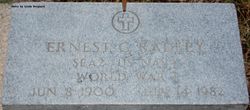
| Description | : | Esther Josephine Radley, the daughter of Henry and Hazel Mendenhall Nicholson, was born August 16, 1915 in Peterson, IA. After graduating from Peterson High School, Esther lived in Battle Creek for five years before settling in Spencer. Esther married Ernest Radley on March 27, 1943 in South Sioux City, NE and was a homemaker. Esther enjoyed attending the First Baptist Church services, cooking meals, two hours of story time a day and spending time with family and friends. She was preceded in death by her husband in 1982, her parents, her son Harry, her daughter Getta, two brothers, Todd and Tim, and... Read More |
frequently asked questions (FAQ):
-
Where is Esther Josephine Nicholson Radley's memorial?
Esther Josephine Nicholson Radley's memorial is located at: Silver Lake Cemetery, Athol, Worcester County, USA.
-
When did Esther Josephine Nicholson Radley death?
Esther Josephine Nicholson Radley death on 5 Mar 2010 in
-
Where are the coordinates of the Esther Josephine Nicholson Radley's memorial?
Latitude: 42.6018982
Longitude: -72.2249985
Family Members:
Parent
Spouse

Children

Flowers:


Nearby Cemetories:
1. Silver Lake Cemetery
Athol, Worcester County, USA
Coordinate: 42.6018982, -72.2249985
2. Old Burial Ground
Athol, Worcester County, USA
Coordinate: 42.5889840, -72.2270420
3. Mount Pleasant Cemetery
Athol, Worcester County, USA
Coordinate: 42.5943985, -72.2433014
4. Highland Cemetery
Athol, Worcester County, USA
Coordinate: 42.5889015, -72.2110977
5. Old Pleasant Street Cemetery
Athol, Worcester County, USA
Coordinate: 42.5860800, -72.2145100
6. Calvary Cemetery
Athol, Worcester County, USA
Coordinate: 42.5842018, -72.2117004
7. Chestnut Hill Cemetery
Athol, Worcester County, USA
Coordinate: 42.6296997, -72.2042007
8. Gethsemane Cemetery
Athol, Worcester County, USA
Coordinate: 42.5791960, -72.2578310
9. Jones Cemetery
Orange, Franklin County, USA
Coordinate: 42.6148224, -72.2728806
10. Tully Cemetery
Orange, Franklin County, USA
Coordinate: 42.6398000, -72.2504700
11. Ellinwood Cemetery
Athol, Worcester County, USA
Coordinate: 42.5589400, -72.2142600
12. North Orange Cemetery
Orange, Franklin County, USA
Coordinate: 42.6360230, -72.2690530
13. Maple Cemetery
Royalston, Worcester County, USA
Coordinate: 42.6545520, -72.2235460
14. Fay Cemetery
Athol, Worcester County, USA
Coordinate: 42.5466300, -72.2364200
15. Adams Road Cemetery
Athol, Worcester County, USA
Coordinate: 42.5425560, -72.2133610
16. Central Cemetery
Orange, Franklin County, USA
Coordinate: 42.5932960, -72.3066420
17. Stratton Cemetery
Athol, Worcester County, USA
Coordinate: 42.5407872, -72.2151265
18. New Sherborn Cemetery
Athol, Worcester County, USA
Coordinate: 42.5402985, -72.2166977
19. Riverside Cemetery
Royalston, Worcester County, USA
Coordinate: 42.6302986, -72.1453018
20. Nahum Greene Gravesite
Royalston, Worcester County, USA
Coordinate: 42.6545700, -72.1712900
21. South Cemetery
Orange, Franklin County, USA
Coordinate: 42.5657880, -72.3043410
22. Old Centre Cemetery
Royalston, Worcester County, USA
Coordinate: 42.6713982, -72.1889038
23. Lower Cemetery
Phillipston, Worcester County, USA
Coordinate: 42.5583000, -72.1425018
24. Harvard Cemetery
Petersham, Worcester County, USA
Coordinate: 42.5305000, -72.1896100