
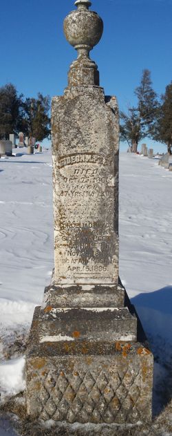

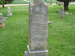
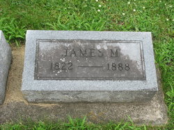
Gideon Nelson Peet
| Birth | : | 2 Sep 1814 Solon, Cortland County, New York, USA |
| Death | : | 25 Oct 1861 Fairview, Jones County, Iowa, USA |
| Burial | : | Sophia Magdalena, Soderakra, Torsås kommun, Sweden |
| Coordinate | : | 56.4457031, 16.0717222 |
| Plot | : | Row 23 |
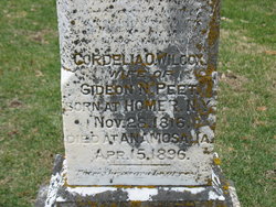
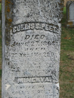
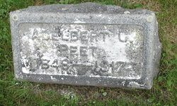
| Description | : | From the History of Jones County, 1879, page 588 Gideon N. Peet, deceased, was born Sept. 2, 1814 in Cortland Co., N. Y.; in 1839, he came to Jones Co., Iowa; he died Oct. 25, 1861. He married Miss Cordelia O. Wilcox March 29, 1840; they had four children, three of whom are living-Theresa V. (now Mrs. Charles Myrick), Eber G. and Adelbert C.; lost-Collins S.; in 1863, aged 23 years. Mrs. Peet owns about two hundred and fifty acres of land on Sec. 16; P. O. Martelle |
frequently asked questions (FAQ):
-
Where is Gideon Nelson Peet's memorial?
Gideon Nelson Peet's memorial is located at: Sophia Magdalena, Soderakra, Torsås kommun, Sweden.
-
When did Gideon Nelson Peet death?
Gideon Nelson Peet death on 25 Oct 1861 in Fairview, Jones County, Iowa, USA
-
Where are the coordinates of the Gideon Nelson Peet's memorial?
Latitude: 56.4457031
Longitude: 16.0717222
Family Members:
Parent
Spouse
Siblings

Children
Flowers:


Nearby Cemetories:
1. Sophia Magdalena
Soderakra, Torsås kommun, Sweden
Coordinate: 56.4457031, 16.0717222
2. Arby kyrka
Arby, Hjo kommun, Sweden
Coordinate: 56.5666670, 16.1227780
3. Gullabo kyrkogård
Gullabo, Torsås kommun, Sweden
Coordinate: 56.4636883, 15.8071821
4. Karlslunda churchyard
Paryd, Kalmar kommun, Sweden
Coordinate: 56.5685926, 15.9182519
5. Ljungby cemetery
Ljungbyholm, Kalmar kommun, Sweden
Coordinate: 56.6325710, 16.1683770
6. Mörbylånga Kyrkogård
Mörbylånga, Mörbylånga kommun, Sweden
Coordinate: 56.5197335, 16.3979088
7. Kastlösa Kyrkogård
Kastlosa, Mörbylånga kommun, Sweden
Coordinate: 56.4585433, 16.4293813
8. Resmo kyrkogård
Resmo, Mörbylånga kommun, Sweden
Coordinate: 56.5415446, 16.4438174
9. Sankt Sigfrids kyrkogård
Sankt Sigfrid, Nybro kommun, Sweden
Coordinate: 56.6944100, 15.9999200
10. Södra Kyrkogården
Kalmar, Kalmar kommun, Sweden
Coordinate: 56.6579816, 16.3514349
11. Hulterstad Kyrkogård
Hulterstad, Mörbylånga kommun, Sweden
Coordinate: 56.4494100, 16.5675470
12. Jämjö kyrkogård
Jamjo, Karlskrona kommun, Sweden
Coordinate: 56.1921200, 15.8318400
13. Torslunda kyrkogård
Torslunda, Mörbylånga kommun, Sweden
Coordinate: 56.6332780, 16.5152500
14. Lösens kyrka
Lyckeby, Karlskrona kommun, Sweden
Coordinate: 56.1965965, 15.6882357
15. Algutsrums Kyrkogård
Farjestaden, Mörbylånga kommun, Sweden
Coordinate: 56.6785456, 16.5280047
16. Fridlevstads Kyrkogård
Fridlevstad, Karlskrona kommun, Sweden
Coordinate: 56.2696868, 15.5388697
17. Åby kyrka
Kalmar, Kalmar kommun, Sweden
Coordinate: 56.7811110, 16.2872200
18. Tvings Kyrkogård
Tving, Karlskrona kommun, Sweden
Coordinate: 56.3092001, 15.4655756
19. Långasjö kyrkogård
Langasjo, Emmaboda kommun, Sweden
Coordinate: 56.5789481, 15.4445904
20. Wämö
Karlskrona, Karlskrona kommun, Sweden
Coordinate: 56.1804250, 15.6017650
21. Torhamns kyrkogård
Torhamn, Karlskrona kommun, Sweden
Coordinate: 56.0952220, 15.8329000
22. Sturkö Kyrkogård
Sturko, Karlskrona kommun, Sweden
Coordinate: 56.0886899, 15.6963390
23. Hjortsberga kyrkogård
Johannishus, Ronneby kommun, Sweden
Coordinate: 56.2255649, 15.4078853
24. Listerby Cemetery
Listerby, Ronneby kommun, Sweden
Coordinate: 56.1953366, 15.4065383