
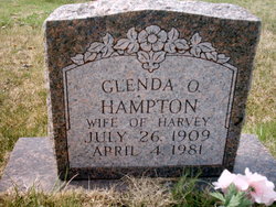
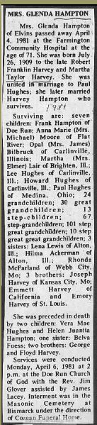
Glenda Opal Harvey Hampton
| Birth | : | 26 Jul 1909 Missouri, USA |
| Death | : | 4 Apr 1981 Farmington, St. Francois County, Missouri, USA |
| Burial | : | Wares Chapel Cemetery, West Manchester, Preble County, USA |
| Coordinate | : | 39.8644447, -84.6466675 |
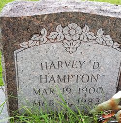
| Description | : | First Husband: Paul Hughes Second Husband: Harvey Druwey Hampton Daughter of Robert F. Harvey & Martha Taylor |
frequently asked questions (FAQ):
-
Where is Glenda Opal Harvey Hampton's memorial?
Glenda Opal Harvey Hampton's memorial is located at: Wares Chapel Cemetery, West Manchester, Preble County, USA.
-
When did Glenda Opal Harvey Hampton death?
Glenda Opal Harvey Hampton death on 4 Apr 1981 in Farmington, St. Francois County, Missouri, USA
-
Where are the coordinates of the Glenda Opal Harvey Hampton's memorial?
Latitude: 39.8644447
Longitude: -84.6466675
Family Members:
Parent

Spouse
Siblings
Children
Flowers:


Nearby Cemetories:
1. Wares Chapel Cemetery
West Manchester, Preble County, USA
Coordinate: 39.8644447, -84.6466675
2. Wehrly Cemetery
Eldorado, Preble County, USA
Coordinate: 39.8598250, -84.6676020
3. Prices Creek German Baptist Cemetery
Hamburg, Preble County, USA
Coordinate: 39.8636017, -84.6771011
4. Old German Baptist Brethren Church Cemetery
Eldorado, Preble County, USA
Coordinate: 39.8636060, -84.6781430
5. Pleasant View Church Cemetery
Eldorado, Preble County, USA
Coordinate: 39.8860700, -84.6611710
6. Monroe Cemetery
Eldorado, Preble County, USA
Coordinate: 39.8878710, -84.6562140
7. Dry Fork Cemetery
West Manchester, Preble County, USA
Coordinate: 39.8795433, -84.6157150
8. Hamburg Cemetery
Hamburg, Preble County, USA
Coordinate: 39.8869320, -84.6791360
9. Stump Cemetery
Eldorado, Preble County, USA
Coordinate: 39.8577995, -84.6958008
10. Brown Cemetery
West Manchester, Preble County, USA
Coordinate: 39.8950005, -84.5958328
11. Zion Cemetery
Eaton, Preble County, USA
Coordinate: 39.8104858, -84.6306305
12. Railroad Cemetery
Castine, Darke County, USA
Coordinate: 39.9183410, -84.6244710
13. Gettysburg Cemetery
Gettysburg, Preble County, USA
Coordinate: 39.8349991, -84.7232971
14. Sherer Cemetery
Preble County, USA
Coordinate: 39.8083344, -84.6966629
15. Castine Cemetery
Castine, Darke County, USA
Coordinate: 39.9306050, -84.6210650
16. Old Castine Cemetery
Castine, Darke County, USA
Coordinate: 39.9383011, -84.6250000
17. Spacht Cemetery
Preble County, USA
Coordinate: 39.7875500, -84.6774500
18. Roselawn Cemetery
Lewisburg, Preble County, USA
Coordinate: 39.8518982, -84.5428009
19. Otterbein Cemetery
Otterbein, Darke County, USA
Coordinate: 39.9453270, -84.6705110
20. Lower Lewisburg Cemetery
Lewisburg, Preble County, USA
Coordinate: 39.8453331, -84.5369339
21. Orangeburg Cholera Cemetery
New Paris, Preble County, USA
Coordinate: 39.8319170, -84.7514870
22. Bonebrake Cemetery
New Hope, Preble County, USA
Coordinate: 39.7867200, -84.6999600
23. Weatherly Cemetery
Preble County, USA
Coordinate: 39.8427180, -84.7605810
24. Bantz Cemetery
Brennersville, Preble County, USA
Coordinate: 39.7988160, -84.5632180