
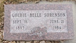
Goldie Belle Tuttle Sorenson
| Birth | : | 16 Sep 1894 Newcastle, Dixon County, Nebraska, USA |
| Death | : | 21 Jun 1984 Billings, Yellowstone County, Montana, USA |
| Burial | : | Forsyth Cemetery, Forsyth, Rosebud County, USA |
| Coordinate | : | 46.2689018, -106.6528015 |
| Inscription | : | 1st Addition Section B Lot 2 Block 8 |
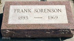
| Description | : | SOURCE: Death Certificate: '''''''''''''''''''''''''''' The Billings Gazette, MT, 6/24/1984 Sunday Page 12 Goldie B. Sorenson FORSYTH, MT. ---- Goldie B. Sorenson and her husband moved to Pease Bottom, MT., in 1917, where they farmed and ranched until moving to Forsyth in 1920. Mrs. Sorenson, 88, died Thursday at St. Vincent's Hospital in Billings. Born in Newcastle, NE., the daughter of Orrin C. and Ema Brown Tuttle. She spent her youth and attended schools in Nebraska. She married Frank W. Sorenson on Oct. 21, 1915, in Ponca, NE. He died Oct. 4, 1969. She was... Read More |
frequently asked questions (FAQ):
-
Where is Goldie Belle Tuttle Sorenson's memorial?
Goldie Belle Tuttle Sorenson's memorial is located at: Forsyth Cemetery, Forsyth, Rosebud County, USA.
-
When did Goldie Belle Tuttle Sorenson death?
Goldie Belle Tuttle Sorenson death on 21 Jun 1984 in Billings, Yellowstone County, Montana, USA
-
Where are the coordinates of the Goldie Belle Tuttle Sorenson's memorial?
Latitude: 46.2689018
Longitude: -106.6528015
Family Members:
Parent
Spouse
Siblings

Children

Flowers:


Nearby Cemetories:
1. Forsyth Cemetery
Forsyth, Rosebud County, USA
Coordinate: 46.2689018, -106.6528015
2. Rosebud Cemetery
Rosebud, Rosebud County, USA
Coordinate: 46.2689018, -106.4381027
3. Howard Cemetery
Rosebud County, USA
Coordinate: 46.2621994, -106.9222031
4. Hathaway Cemetery
Rosebud County, USA
Coordinate: 46.2616997, -106.2185974
5. Colstrip Cemetery
Colstrip, Rosebud County, USA
Coordinate: 45.9096985, -106.6194000
6. Memorial Vale Cemetery
Hysham, Treasure County, USA
Coordinate: 46.2552986, -107.2307968
7. Bean Cemetery
Rosebud County, USA
Coordinate: 45.8535995, -106.4011002
8. Brown Cemetery
Colstrip, Rosebud County, USA
Coordinate: 45.8321991, -106.4180984
9. Lee Cemetery
Rosebud County, USA
Coordinate: 45.7792015, -106.5413971
10. Rancher Cemetery
Myers, Treasure County, USA
Coordinate: 46.2580986, -107.4197006
11. Fort Keogh Cemetery
Custer County, USA
Coordinate: 46.3800011, -105.8874969
12. Vanstel Cemetery
Rosebud County, USA
Coordinate: 46.7872009, -106.8942032
13. Calvary Cemetery
Miles City, Custer County, USA
Coordinate: 46.3816986, -105.8249969
14. Eastern Montana State Veterans Cemetery
Miles City, Custer County, USA
Coordinate: 46.3807564, -105.8246536
15. Old Calvary Cemetery
Miles City, Custer County, USA
Coordinate: 46.3807600, -105.8246500
16. Custer County Cemetery
Miles City, Custer County, USA
Coordinate: 46.3891983, -105.8264008
17. Pine Hills School Cemetery
Miles City, Custer County, USA
Coordinate: 46.4077988, -105.8167038
18. Rock Springs Cemetery
Rock Springs, Rosebud County, USA
Coordinate: 46.7847800, -106.1411500
19. Pine Crest Cemetery
Custer County, USA
Coordinate: 46.4564018, -105.7789001
20. Junction City Cemetery
Yellowstone County, USA
Coordinate: 46.1437320, -107.5493300
21. Lame Deer Cemetery
Lame Deer, Rosebud County, USA
Coordinate: 45.6264000, -106.6619034
22. Custer Cemetery
Custer, Yellowstone County, USA
Coordinate: 46.1270690, -107.5700030
23. Muddy Creek Cemetery
Muddy, Big Horn County, USA
Coordinate: 45.5741997, -106.7406006
24. Saint Labre Cemetery
Ashland, Rosebud County, USA
Coordinate: 45.6070930, -106.2836910