
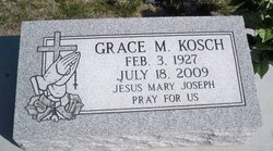
Grace Marie Bernt Kosch
| Birth | : | 3 Feb 1927 Polk County, Nebraska, USA |
| Death | : | 18 Jul 2009 Columbus, Platte County, Nebraska, USA |
| Burial | : | Manukau Memorial Gardens, Manukau, Auckland Council, New Zealand |
| Coordinate | : | -36.9944380, 174.8397300 |
| Description | : | Daughter of Albert E. & Hilda (Zeleny) Bernt. Following her graduation from high school she received her teachers training and taught in Polk County. She married Max Kosch on June 30, 1947 in Columbus, Nebraska. She was a member of St. Bonaventure Church, St. Bonaventure Perpetual Adoration, and a member of The 3rd Order of St. Francis and Legion of Mary. Grace is survived by: Husband: Max Kosch of Columbus, NE Daughter: Ann Kosch of Manhatten, KS Daughter: Mary Jane (Joe) Noble of Albion, NE Son: Stanley Kosch of Manhatten, KS Daughter: Paulette (Greg) Gembica of Columbus, NE Sister: Rita Barba of Omaha,... Read More |
frequently asked questions (FAQ):
-
Where is Grace Marie Bernt Kosch's memorial?
Grace Marie Bernt Kosch's memorial is located at: Manukau Memorial Gardens, Manukau, Auckland Council, New Zealand.
-
When did Grace Marie Bernt Kosch death?
Grace Marie Bernt Kosch death on 18 Jul 2009 in Columbus, Platte County, Nebraska, USA
-
Where are the coordinates of the Grace Marie Bernt Kosch's memorial?
Latitude: -36.9944380
Longitude: 174.8397300
Family Members:
Parent

Spouse
Siblings

Children

Flowers:


Nearby Cemetories:
1. Manukau Memorial Gardens
Manukau, Auckland Council, New Zealand
Coordinate: -36.9944380, 174.8397300
2. Papatoetoe Cemetery
Papatoetoe, Auckland Council, New Zealand
Coordinate: -36.9893110, 174.8373530
3. St. John's Presbyterian Church Cemetery
Papatoetoe, Auckland Council, New Zealand
Coordinate: -36.9674185, 174.8598178
4. Woodside Methodist Cemetery
Manukau, Auckland Council, New Zealand
Coordinate: -36.9929680, 174.8837860
5. St. David's Anglican Churchyard
Wiri, Auckland Council, New Zealand
Coordinate: -37.0025400, 174.8886150
6. Mangere Presbyterian Cemetery
Mangere, Auckland Council, New Zealand
Coordinate: -36.9750197, 174.7924783
7. Nixon Memorial
Ōtāhūhū, Auckland Council, New Zealand
Coordinate: -36.9499366, 174.8449909
8. St. Joseph and St. Joachim Catholic Cemetery
Ōtāhūhū, Auckland Council, New Zealand
Coordinate: -36.9436100, 174.8490100
9. Laurie-Gibbons Memorial Park
Weymouth, Auckland Council, New Zealand
Coordinate: -37.0440600, 174.8586790
10. Mangere Lawn Cemetery
Mangere, Auckland Council, New Zealand
Coordinate: -36.9626150, 174.7857000
11. Otahuhu Public Cemetery
Ōtāhūhū, Auckland Council, New Zealand
Coordinate: -36.9377500, 174.8432390
12. Holy Trinity Memorial Park
Ōtāhūhū, Auckland Council, New Zealand
Coordinate: -36.9374510, 174.8448580
13. St. John's Church Cemetery
East Tamaki, Auckland Council, New Zealand
Coordinate: -36.9522250, 174.8964540
14. St. Paul's Anglican Cemetery
East Tamaki, Auckland Council, New Zealand
Coordinate: -36.9615200, 174.9082000
15. Flat Bush Cemetery
East Tamaki, Auckland Council, New Zealand
Coordinate: -36.9563500, 174.9097100
16. Mangere Piriti Urupā St. James Churchyard
Mangere, Auckland Council, New Zealand
Coordinate: -36.9418970, 174.7835260
17. Waikaraka Cemetery
Ōnehunga, Auckland Council, New Zealand
Coordinate: -36.9297140, 174.7967170
18. Onehunga Catholic Cemetery
Ōnehunga, Auckland Council, New Zealand
Coordinate: -36.9224360, 174.7884560
19. Our Lady of the Assumption Catholic Church
Ōnehunga, Auckland Council, New Zealand
Coordinate: -36.9223690, 174.7884530
20. St. Peter's Anglican Cemetery
Ōnehunga, Auckland Council, New Zealand
Coordinate: -36.9227113, 174.7847550
21. Alfriston Cemetery
Auckland Council, New Zealand
Coordinate: -37.0133660, 174.9479400
22. St Matthias Churchyard
Panmure, Auckland Council, New Zealand
Coordinate: -36.9053300, 174.8577200
23. St. Patrick's Roman Catholic Church Cemetery
Panmure, Auckland Council, New Zealand
Coordinate: -36.9029680, 174.8564960
24. Pakuranga Methodist Cemetery
Pakuranga, Auckland Council, New Zealand
Coordinate: -36.9054000, 174.8914900