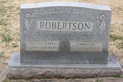
Grover Cleveland “Cleve” Robertson
| Birth | : | 10 Mar 1894 North Carolina, USA |
| Death | : | 19 Feb 1970 Mount Airy, Surry County, North Carolina, USA |
| Burial | : | Ferrell Cemetery, Comfort, Boone County, USA |
| Coordinate | : | 38.1296997, -81.6066971 |
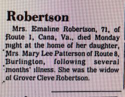
| Description | : | Husband of Emmaline M. Robertson; son of Billy and Priscilla (McCrow) Robertson. |
frequently asked questions (FAQ):
-
Where is Grover Cleveland “Cleve” Robertson's memorial?
Grover Cleveland “Cleve” Robertson's memorial is located at: Ferrell Cemetery, Comfort, Boone County, USA.
-
When did Grover Cleveland “Cleve” Robertson death?
Grover Cleveland “Cleve” Robertson death on 19 Feb 1970 in Mount Airy, Surry County, North Carolina, USA
-
Where are the coordinates of the Grover Cleveland “Cleve” Robertson's memorial?
Latitude: 38.1296997
Longitude: -81.6066971
Family Members:
Parent
Spouse
Children
Flowers:
Nearby Cemetories:
1. Amick Cemetery
Comfort, Boone County, USA
Coordinate: 38.1286030, -81.6153430
2. Meadows Cemetery
Boone County, USA
Coordinate: 38.1286011, -81.6156006
3. Coon Cemetery
Boone County, USA
Coordinate: 38.1225014, -81.6185989
4. Adkins Family Cemetery
Comfort, Boone County, USA
Coordinate: 38.1300316, -81.5870514
5. Fauber Cemetery
Bloomingrose, Boone County, USA
Coordinate: 38.1458015, -81.6318970
6. Bloomingrose Cemetery
Bloomingrose, Boone County, USA
Coordinate: 38.1408790, -81.6371880
7. Mechanics And Miners Cemetery
Bloomingrose, Boone County, USA
Coordinate: 38.1411018, -81.6374969
8. Indian Creek Cemetery
Boone County, USA
Coordinate: 38.1268997, -81.6541977
9. Evans Family Cemetery
Boone County, USA
Coordinate: 38.1413994, -81.6556015
10. Pettry Cemetery
Comfort, Boone County, USA
Coordinate: 38.1189003, -81.5417023
11. Kirk Cemetery
Ashford, Boone County, USA
Coordinate: 38.1761017, -81.6616974
12. Courtney Cemetery
Boone County, USA
Coordinate: 38.1767006, -81.6622009
13. Price Cemetery
Ashford, Boone County, USA
Coordinate: 38.1745000, -81.6777250
14. Mount Hope Cemetery
Dawes, Kanawha County, USA
Coordinate: 38.1077995, -81.5186005
15. Mahone Church Hill Cemetery
Boone County, USA
Coordinate: 38.1792160, -81.6744090
16. Barker Cemetery
Boone County, USA
Coordinate: 38.1800003, -81.6753006
17. Foster Cemetery
Dawes, Kanawha County, USA
Coordinate: 38.1053009, -81.5147018
18. Harless Cemetery
Ashford, Boone County, USA
Coordinate: 38.1615670, -81.6958590
19. Javins Cemetery
Boone County, USA
Coordinate: 38.1363983, -81.7058029
20. Bias Cemetery
Boone County, USA
Coordinate: 38.1081009, -81.7033005
21. Javins Cemetery
Boone County, USA
Coordinate: 38.1369019, -81.7071991
22. Burnside Cemetery
Andrew, Boone County, USA
Coordinate: 38.1037440, -81.7065990
23. Perry Cemetery
Ashford, Boone County, USA
Coordinate: 38.1850014, -81.6893997
24. McDerment Cemetery
Boone County, USA
Coordinate: 38.1850014, -81.6928024

