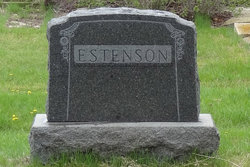
| Birth | : | 14 Feb 1886 Hendrum, Norman County, Minnesota, USA |
| Death | : | 23 Aug 1944 Sarles, Cavalier County, North Dakota, USA |
| Burial | : | Sarles Cemetery, Sarles, Cavalier County, USA |
| Coordinate | : | 48.9436290, -98.9900330 |
| Description | : | Gina was born 14 Feb 1886 in Mary Township of Norman County, MN. She was the 6th of 9 children born to Ole and Elen Anna Estenson. She attended rural school and helped around the farm home. She married Christ Sand in 1910 in Crystal City, Manitoba, Canada. Christ was born 13 Apr 1877 at Ada, Norman County, MN. They farmed near Sarles, ND for many years. Gina spent many hours in the cook car during threshing season. She cooked for a crew of about twenty men. She also helped to milk the cows... Read More |
frequently asked questions (FAQ):
-
Where is Gunhild “Gina” Estenson Sand's memorial?
Gunhild “Gina” Estenson Sand's memorial is located at: Sarles Cemetery, Sarles, Cavalier County, USA.
-
When did Gunhild “Gina” Estenson Sand death?
Gunhild “Gina” Estenson Sand death on 23 Aug 1944 in Sarles, Cavalier County, North Dakota, USA
-
Where are the coordinates of the Gunhild “Gina” Estenson Sand's memorial?
Latitude: 48.9436290
Longitude: -98.9900330
Family Members:
Parent
Spouse
Siblings
Children
Flowers:
Nearby Cemetories:
1. Sarles Cemetery
Sarles, Cavalier County, USA
Coordinate: 48.9436290, -98.9900330
2. Woodbridge Cemetery
Cypress Township, Cavalier County, USA
Coordinate: 48.9817009, -98.9344025
3. Dash Cemetery
Towner County, USA
Coordinate: 48.9641991, -99.0830994
4. Corinthian Cemetery
Calvin, Cavalier County, USA
Coordinate: 48.8622017, -98.9356003
5. Byron Cemetery
Byron Township, Cavalier County, USA
Coordinate: 48.9644012, -98.8356018
6. Ellison Cemetery
Rock Lake, Towner County, USA
Coordinate: 48.7906700, -99.0921900
7. Clyde Cemetery
Bruce Township, Cavalier County, USA
Coordinate: 48.7764015, -98.8891983
8. Clearwater Cemetery
Clearwater, Pilot Mound Census Division, Canada
Coordinate: 49.1336470, -99.0109000
9. Salem Evangelical Cemetery
Clyde, Cavalier County, USA
Coordinate: 48.7766500, -98.8465600
10. Evangelical Cemetery
Huron Township, Cavalier County, USA
Coordinate: 48.7766991, -98.8460999
11. Crystal City Cemetery
Crystal City, Pilot Mound Census Division, Canada
Coordinate: 49.1415472, -98.9532750
12. Hannah Cemetery
Hannah, Cavalier County, USA
Coordinate: 48.9780998, -98.6849976
13. Mather Cemetery
Mather, Pilot Mound Census Division, Canada
Coordinate: 49.1034180, -99.1819950
14. Greenway Family Cemetery
Crystal City, Pilot Mound Census Division, Canada
Coordinate: 49.1534410, -98.9532030
15. Rock Lake Community Cemetery
Rock Lake, Towner County, USA
Coordinate: 48.8024810, -99.2581270
16. All Nations Lutheran Cemetery
Rock Lake, Towner County, USA
Coordinate: 48.7807999, -99.2619019
17. Brumbaugh Cemetery
Towner County, USA
Coordinate: 48.7467003, -99.2102966
18. McLean Family Cemetery
Cartwright, Pilot Mound Census Division, Canada
Coordinate: 49.0441800, -99.3344400
19. Brethren Cemetery
Twin Hill Township, Towner County, USA
Coordinate: 48.6928250, -99.0467790
20. Snowflake Community Cemetery
Snowflake, Pilot Mound Census Division, Canada
Coordinate: 49.0296400, -98.6118900
21. Saint Michaels Cemetery
Dresden Township, Cavalier County, USA
Coordinate: 48.8983890, -98.5952650
22. Hansboro Cemetery
Hansboro, Towner County, USA
Coordinate: 48.9565056, -99.3942500
23. Greenwood Cemetery South
Pilot Mound, Pilot Mound Census Division, Canada
Coordinate: 49.2063300, -98.9077530
24. Greenwood Cemetery
Pilot Mound, Pilot Mound Census Division, Canada
Coordinate: 49.2074600, -98.9077700


