
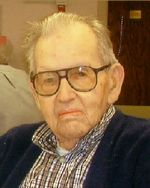
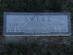
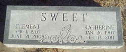
Guy Clement Sweet
| Birth | : | 1 Apr 1907 Decatur, Burt County, Nebraska, USA |
| Death | : | 21 Jun 2008 Hastings, Adams County, Nebraska, USA |
| Burial | : | Trinity Churchyard Cemetery, Holderness, Grafton County, USA |
| Coordinate | : | 43.7566000, -71.6696700 |
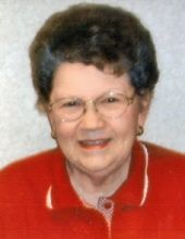
| Description | : | Son of Guy R. & Estella (Anson) Sweet. Married to Katherine Orr on 2-15-1928. Clement started farming with his father on a farm west of Decatur, later he moved from the farm into Decatur where he operated a service station and ran a tank wagon. In 1954 he moved to Fremont where he operated the Mobil bulk plant. He moved to Dillon, Montana in 1956 where he worked in a gold mill. He returned to Decatur 1958, again operating the service station and tank wagon. He became the mayor of Decatur in 1972 and he was the volunteer fire chief. After he... Read More |
frequently asked questions (FAQ):
-
Where is Guy Clement Sweet's memorial?
Guy Clement Sweet's memorial is located at: Trinity Churchyard Cemetery, Holderness, Grafton County, USA.
-
When did Guy Clement Sweet death?
Guy Clement Sweet death on 21 Jun 2008 in Hastings, Adams County, Nebraska, USA
-
Where are the coordinates of the Guy Clement Sweet's memorial?
Latitude: 43.7566000
Longitude: -71.6696700
Family Members:
Parent

Spouse

Children
Flowers:


Nearby Cemetories:
1. Trinity Churchyard Cemetery
Holderness, Grafton County, USA
Coordinate: 43.7566000, -71.6696700
2. Church Hill Cemetery
Ashland, Grafton County, USA
Coordinate: 43.7455560, -71.6522220
3. Riverside Cemetery
Plymouth, Grafton County, USA
Coordinate: 43.7736000, -71.6908100
4. Lower Intervale Cemetery
Plymouth, Grafton County, USA
Coordinate: 43.7316100, -71.6733800
5. Shaw Cemetery
Holderness, Grafton County, USA
Coordinate: 43.7436110, -71.6225000
6. Owl Brook Cemetery
Ashland, Grafton County, USA
Coordinate: 43.7333200, -71.6300100
7. Dearborn Cemetery
Plymouth, Grafton County, USA
Coordinate: 43.7597220, -71.7213890
8. Hicks Hill Cemetery
Ashland, Grafton County, USA
Coordinate: 43.7277780, -71.6313890
9. Sanborn Cemetery
Holderness, Grafton County, USA
Coordinate: 43.7612800, -71.6050600
10. Union Cemetery
Bridgewater, Grafton County, USA
Coordinate: 43.7093500, -71.6763500
11. Pleasant Valley Cemetery
Plymouth, Grafton County, USA
Coordinate: 43.7741300, -71.7364600
12. Mitchell Family Cemetery
Bridgewater, Grafton County, USA
Coordinate: 43.7052780, -71.6838890
13. Beech Hill Burying Ground
Campton, Grafton County, USA
Coordinate: 43.8000620, -71.7119690
14. Bartlett Cemetery
Plymouth, Grafton County, USA
Coordinate: 43.7542400, -71.7436200
15. Blair Cemetery
Campton, Grafton County, USA
Coordinate: 43.8111000, -71.6603012
16. Spencer Cemetery
Grafton County, USA
Coordinate: 43.7720080, -71.7455500
17. Calvary Independent Baptist Church Cemetery
Plymouth, Grafton County, USA
Coordinate: 43.7639220, -71.7484290
18. Bog Road Cemetery
Campton, Grafton County, USA
Coordinate: 43.8152149, -71.6666793
19. Clark Cemetery
Ashland, Grafton County, USA
Coordinate: 43.7133330, -71.6113890
20. Howe-Clark Cemetery
Grafton County, USA
Coordinate: 43.7133330, -71.6113890
21. Turnpike Cemetery
Plymouth, Grafton County, USA
Coordinate: 43.7492700, -71.7532800
22. Blaisdell Cemetery
Campton, Grafton County, USA
Coordinate: 43.8169440, -71.6555560
23. Mooney Cemetery
Ashland, Grafton County, USA
Coordinate: 43.7019440, -71.6269440
24. Green Grove Cemetery
Ashland, Grafton County, USA
Coordinate: 43.6975400, -71.6401500