
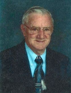
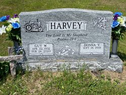
Guy Willard Harvey
| Birth | : | 22 Apr 1932 Swanton, Garrett County, Maryland, USA |
| Death | : | 26 Feb 2020 Grantsville, Garrett County, Maryland, USA |
| Burial | : | Rose Hill Cemetery, North Glade, Garrett County, USA |
| Coordinate | : | 39.4991989, -79.2450027 |
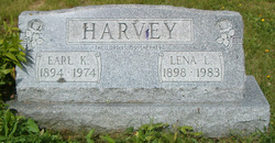
| Description | : | Guy Willard Harvey, 87, of Swanton, MD died Wednesday, February 26, 2020, at Goodwill Mennonite Home, Grantsville, MD. Born April 22, 1932, in Swanton, he was the son of the late Earl K. and Lena L. (Beckman) Harvey. He was also preceded in death by nine brothers and four sisters. Guy was a farmer and a former member of the Garrett County Farm Bureau. He was a veteran who served in the U.S. Army. He was the oldest member of the Deep Creek Baptist Church where he was a trustee and an usher for many years. He was a graduate... Read More |
frequently asked questions (FAQ):
-
Where is Guy Willard Harvey's memorial?
Guy Willard Harvey's memorial is located at: Rose Hill Cemetery, North Glade, Garrett County, USA.
-
When did Guy Willard Harvey death?
Guy Willard Harvey death on 26 Feb 2020 in Grantsville, Garrett County, Maryland, USA
-
Where are the coordinates of the Guy Willard Harvey's memorial?
Latitude: 39.4991989
Longitude: -79.2450027
Family Members:
Parent

Siblings

Flowers:


Nearby Cemetories:
1. Rose Hill Cemetery
North Glade, Garrett County, USA
Coordinate: 39.4991989, -79.2450027
2. Alexander Lohr Family Cemetery
North Glade, Garrett County, USA
Coordinate: 39.5196991, -79.2472000
3. Pritts Cemetery
Garrett County, USA
Coordinate: 39.5353012, -79.2307968
4. Glendale Cemetery
Oakland, Garrett County, USA
Coordinate: 39.5085983, -79.2953033
5. Friend Cemetery
Altamont, Garrett County, USA
Coordinate: 39.4420950, -79.2955100
6. Wilson Cemetery
Altamont, Garrett County, USA
Coordinate: 39.4343600, -79.2764600
7. Beckman Cemetery
Garrett County, USA
Coordinate: 39.4350014, -79.2850037
8. Murphy Cemetery
Garrett County, USA
Coordinate: 39.5432000, -79.1673900
9. Evans Cemetery
Kitzmiller, Garrett County, USA
Coordinate: 39.4273500, -79.2201100
10. Barnard Cemetery
Garrett County, USA
Coordinate: 39.4850006, -79.1461029
11. Paradise Cemetery
Oakland, Garrett County, USA
Coordinate: 39.4712046, -79.3392075
12. Glotfelty Farm Cemetery
McHenry, Garrett County, USA
Coordinate: 39.5708800, -79.2905500
13. Mount Zion Cemetery
Garrett County, USA
Coordinate: 39.4393997, -79.1710968
14. Rodeheaver Cemetery
Oakland, Garrett County, USA
Coordinate: 39.4804680, -79.3521300
15. Ruckle Family Cemetery
Bittinger, Garrett County, USA
Coordinate: 39.5802600, -79.2821900
16. Glade Mennonite Cemetery
Bittinger, Garrett County, USA
Coordinate: 39.5826300, -79.2796700
17. Cherry Glade Cemetery
Accident, Garrett County, USA
Coordinate: 39.5827200, -79.2799500
18. Deer Park Cemetery
Deer Park, Garrett County, USA
Coordinate: 39.4275017, -79.3261032
19. Manor Cemetery
Garrett County, USA
Coordinate: 39.4286003, -79.1505966
20. Bumblebee Ridge Cemetery
McHenry, Garrett County, USA
Coordinate: 39.5774400, -79.3296800
21. Friend Cemetery
Oakland, Garrett County, USA
Coordinate: 39.4913500, -79.3778000
22. Bittinger Cemetery
Bittinger, Garrett County, USA
Coordinate: 39.6006012, -79.2189026
23. Meadow Mountain Mennonite Cemetery
Bittinger, Garrett County, USA
Coordinate: 39.6043890, -79.2603900
24. Orendorf Cemetery
Bittinger, Garrett County, USA
Coordinate: 39.6035700, -79.2197900