

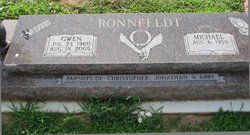
Gwen Michelle Ginger Ronnfeldt
| Birth | : | 23 Jul 1960 Le Mars, Plymouth County, Iowa, USA |
| Death | : | 18 Aug 2005 Springfield, Greene County, Missouri, USA |
| Burial | : | El Paso Cemetery, Derby, Sedgwick County, USA |
| Coordinate | : | 37.5418015, -97.2624969 |
| Description | : | Ronnfeldt, Gwen Michelle, 45, died Thursday morning, Aug. 18, 2005 at St. John's Hospital, Springfield, MO. Visitation 9:30 a.m. to noon; service 2 p.m. both Monday, at Holy Cross Lutheran Church, Wichita; interment 3:30 p.m., El Paso Cemetery, Derby. Born July 23, 1960 in Le Mars, IA, to Dale and Arlene Schmillen Ginger. On March 31, 1979, she married Michael Ronnfeldt in Alta, IA. She was an officer in the Non-Commissioned Officers Wives Club, while her husband served in the USAF. She was a member of Holy Cross Lutheran Church, Wichita, where she was a Sunday school teacher, served in... Read More |
frequently asked questions (FAQ):
-
Where is Gwen Michelle Ginger Ronnfeldt's memorial?
Gwen Michelle Ginger Ronnfeldt's memorial is located at: El Paso Cemetery, Derby, Sedgwick County, USA.
-
When did Gwen Michelle Ginger Ronnfeldt death?
Gwen Michelle Ginger Ronnfeldt death on 18 Aug 2005 in Springfield, Greene County, Missouri, USA
-
Where are the coordinates of the Gwen Michelle Ginger Ronnfeldt's memorial?
Latitude: 37.5418015
Longitude: -97.2624969
Family Members:
Parent

Flowers:


Nearby Cemetories:
1. El Paso Cemetery
Derby, Sedgwick County, USA
Coordinate: 37.5418015, -97.2624969
2. Hillcrest Cemetery
Derby, Sedgwick County, USA
Coordinate: 37.5194435, -97.2202759
3. Prairie Home Scattering Garden
Derby, Sedgwick County, USA
Coordinate: 37.5482715, -97.1903412
4. Waco Cemetery
Waco, Sedgwick County, USA
Coordinate: 37.5242004, -97.3419037
5. Branson Cemetery
Derby, Sedgwick County, USA
Coordinate: 37.6074982, -97.2067032
6. Mulvane Cemetery
Mulvane, Sumner County, USA
Coordinate: 37.4724998, -97.2067032
7. Prairie Garden Cemetery
Peck, Sumner County, USA
Coordinate: 37.4653015, -97.3146973
8. Union Cemetery
Derby, Sedgwick County, USA
Coordinate: 37.5271988, -97.1532974
9. Roll Cemetery
Sedgwick County, USA
Coordinate: 37.5206030, -97.3739950
10. Reflection Pointe Cemetery
Wichita, Sedgwick County, USA
Coordinate: 37.6344800, -97.2264100
11. Littleton Cemetery
Gore Township, Sumner County, USA
Coordinate: 37.4498400, -97.2075500
12. Rose Hill Cemetery
Rose Hill, Butler County, USA
Coordinate: 37.5633011, -97.1177979
13. Council Hill Cemetery
Peck, Sumner County, USA
Coordinate: 37.4466600, -97.3497600
14. Mount Saint Mary Convent Cemetery
Wichita, Sedgwick County, USA
Coordinate: 37.6704000, -97.2904000
15. Greenwood Cemetery
Wichita, Sedgwick County, USA
Coordinate: 37.6067009, -97.4156036
16. Friends Cemetery
Rose Hill, Butler County, USA
Coordinate: 37.5625000, -97.0896988
17. Calvary Cemetery
Wichita, Sedgwick County, USA
Coordinate: 37.6781006, -97.2949982
18. Noel Cemetery
Clearwater, Sedgwick County, USA
Coordinate: 37.4870000, -97.4238300
19. Dunlap Cemetery
Rose Hill, Butler County, USA
Coordinate: 37.5993996, -97.0975037
20. Cornerstone Pentecostal Holiness Church
Wichita, Sedgwick County, USA
Coordinate: 37.6578700, -97.3705700
21. Seltzer Cemetery
Wichita, Sedgwick County, USA
Coordinate: 37.6652000, -97.1672700
22. East Heights United Methodist Memorial Garden
Wichita, Sedgwick County, USA
Coordinate: 37.6854100, -97.2845500
23. Saint James Episcopal Church Columbarium
Wichita, Sedgwick County, USA
Coordinate: 37.6865600, -97.2930000
24. Richland Cemetery
Douglass, Butler County, USA
Coordinate: 37.5119019, -97.0808029