
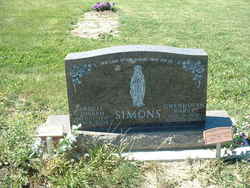

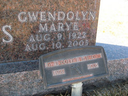
Gwendolyn Marye Pellegrin Simons
| Birth | : | 9 Aug 1922 |
| Death | : | 10 Aug 2005 |
| Burial | : | Saint Aloysius Cemetery, Sturgis, Meade County, USA |
| Coordinate | : | 44.4141340, -103.5193420 |
| Description | : | Wife of Ardell Joseph Simons Aldinger Funeral Home & Cremation Service http://www.webfh.com/fh/obituaries/obituary.cfm?o_id=61815&fh_id=10483 Gwendolyn Marye' Simons (August 9, 1922 - August 10, 2005) Gwendolyn Marye Simons, 83, of Spearfish died August 10, 2005 at her home in Spearfish. Gwendolyn was born to Germain E. Pellegrin and Lydia Virginia (Cox) Pellegrin August 9, 1922 in Sturgis, SD. Gwen lived on the family homestead near Enning and attended the Pellegrin School until her parents bought the Enning Store when she was 9 years of age. She attended school at the Enning School the rest of elementary years. She then attended high school in New Underwood as... Read More |
frequently asked questions (FAQ):
-
Where is Gwendolyn Marye Pellegrin Simons's memorial?
Gwendolyn Marye Pellegrin Simons's memorial is located at: Saint Aloysius Cemetery, Sturgis, Meade County, USA.
-
When did Gwendolyn Marye Pellegrin Simons death?
Gwendolyn Marye Pellegrin Simons death on 10 Aug 2005 in
-
Where are the coordinates of the Gwendolyn Marye Pellegrin Simons's memorial?
Latitude: 44.4141340
Longitude: -103.5193420
Family Members:
Spouse
Flowers:


Nearby Cemetories:
1. Saint Aloysius Cemetery
Sturgis, Meade County, USA
Coordinate: 44.4141340, -103.5193420
2. Bear Butte Cemetery
Sturgis, Meade County, USA
Coordinate: 44.4111595, -103.4947968
3. Fort Meade National Cemetery
Sturgis, Meade County, USA
Coordinate: 44.4021988, -103.4757996
4. Curley Grimes Memorial Cemetery
Sturgis, Meade County, USA
Coordinate: 44.3764500, -103.4691300
5. Black Hills National Cemetery
Sturgis, Meade County, USA
Coordinate: 44.3689003, -103.4753036
6. Crook City Cemetery
Crook City, Lawrence County, USA
Coordinate: 44.4432100, -103.6241500
7. Whitewood Cemetery
Whitewood, Lawrence County, USA
Coordinate: 44.4617820, -103.6330030
8. Oak Ridge Cemetery
Deadwood, Lawrence County, USA
Coordinate: 44.3891983, -103.6766968
9. Galena Cemetery
Galena, Lawrence County, USA
Coordinate: 44.3349220, -103.6438410
10. Anderson Cemetery
Lawrence County, USA
Coordinate: 44.4747009, -103.6896973
11. Saint Ambrose Cemetery
Deadwood, Lawrence County, USA
Coordinate: 44.3821983, -103.7266998
12. Mount Moriah Cemetery
Deadwood, Lawrence County, USA
Coordinate: 44.3760986, -103.7253036
13. Pleasant Valley Cemetery
Tilford, Meade County, USA
Coordinate: 44.3192500, -103.3531160
14. Little Dane Cemetery
Saint Onge, Lawrence County, USA
Coordinate: 44.5252500, -103.6705540
15. Roubaix Cemetery
Roubaix, Lawrence County, USA
Coordinate: 44.2789380, -103.6656600
16. South Lead Cemetery
Lead, Lawrence County, USA
Coordinate: 44.3478510, -103.7606260
17. Gate of Heaven Cemetery
Saint Onge, Lawrence County, USA
Coordinate: 44.5353000, -103.7237000
18. Piedmont Cemetery
Piedmont, Meade County, USA
Coordinate: 44.2425780, -103.3871730
19. West Lead Cemetery
Lead, Lawrence County, USA
Coordinate: 44.3484001, -103.7779999
20. Beals Cemetery
Vale, Butte County, USA
Coordinate: 44.6185989, -103.4366989
21. Vale Cemetery
Vale, Butte County, USA
Coordinate: 44.6138992, -103.4052963
22. Terry Cemetery
Terry, Lawrence County, USA
Coordinate: 44.3344290, -103.8165110
23. Nemo Cemetery
Nemo, Lawrence County, USA
Coordinate: 44.1872800, -103.5066410
24. Mountain Meadow Cemetery
Lawrence County, USA
Coordinate: 44.2038994, -103.6557999