
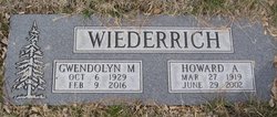
Gwendolyn May “Gwen” Littlefield Wiederrich
| Birth | : | 6 Oct 1929 Big Sandy, Chouteau County, Montana, USA |
| Death | : | 9 Feb 2016 Great Falls, Cascade County, Montana, USA |
| Burial | : | Big Sandy Cemetery, Big Sandy, Chouteau County, USA |
| Coordinate | : | 48.1801170, -110.1207500 |
| Description | : | Gwen was born to Fred & Lela Littlefield in Big Sandy MT. She graduated from high school in 1949 and attended Northern Montana College in Havre. On February 2 1952 she married Howard Wiederrich and became an instant mother to his three girls. The family lived in Great Falls until 1959, when them move to Lodi, California, returning to Montana two years later to open their Auto parts business in Big Sandy. They later retired to the home they built south of Cascade. Gwen was preceded in death by her parents, 6 siblings, her husband, Howard and grandson Marcus Mason. Survived... Read More |
frequently asked questions (FAQ):
-
Where is Gwendolyn May “Gwen” Littlefield Wiederrich's memorial?
Gwendolyn May “Gwen” Littlefield Wiederrich's memorial is located at: Big Sandy Cemetery, Big Sandy, Chouteau County, USA.
-
When did Gwendolyn May “Gwen” Littlefield Wiederrich death?
Gwendolyn May “Gwen” Littlefield Wiederrich death on 9 Feb 2016 in Great Falls, Cascade County, Montana, USA
-
Where are the coordinates of the Gwendolyn May “Gwen” Littlefield Wiederrich's memorial?
Latitude: 48.1801170
Longitude: -110.1207500
Family Members:
Parent
Spouse

Siblings

Flowers:


Nearby Cemetories:
1. Big Sandy Cemetery
Big Sandy, Chouteau County, USA
Coordinate: 48.1801170, -110.1207500
2. Box Elder Cemetery
Box Elder, Hill County, USA
Coordinate: 48.3274000, -110.0095000
3. Kenilworth Cemetery
Chouteau County, USA
Coordinate: 48.2192001, -110.4188995
4. Rocky Boy Cemetery
Rocky Boy, Hill County, USA
Coordinate: 48.2572410, -109.7923690
5. Rocky Boy Gravel Cemetery
Rocky Boy, Hill County, USA
Coordinate: 48.2427720, -109.7596500
6. Cottonwood Lutheran Church Cemetery
Havre, Hill County, USA
Coordinate: 48.4545000, -110.1748000
7. Gildford Hill County Cemetery
Gildford, Hill County, USA
Coordinate: 48.5778008, -110.2957993
8. Clear Lake Cemetery
Chouteau County, USA
Coordinate: 47.7731018, -110.2514038
9. Hingham Union Cemetery
Hingham, Hill County, USA
Coordinate: 48.5601570, -110.4178980
10. Sunset Garden Park
Havre, Hill County, USA
Coordinate: 48.5531006, -109.8019028
11. Graceville Cemetery
Chouteau County, USA
Coordinate: 47.7505989, -110.0875015
12. Hungry Hollow Cemetery
Blaine County, USA
Coordinate: 48.2103004, -109.4677963
13. Highland Cemetery
Havre, Hill County, USA
Coordinate: 48.5463982, -109.6900024
14. Mount Hope Cemetery
Havre, Hill County, USA
Coordinate: 48.5540000, -109.7050000
15. Calvary Cemetery
Havre, Hill County, USA
Coordinate: 48.5457000, -109.6883000
16. Rudyard Cemetery
Rudyard, Hill County, USA
Coordinate: 48.5659500, -110.5390000
17. Riverside Cemetery
Fort Benton, Chouteau County, USA
Coordinate: 47.8402330, -110.6408830
18. Old Shep Gravesite
Fort Benton, Chouteau County, USA
Coordinate: 47.8369000, -110.6557000
19. Milk River Valley Church Graveyard
Hill County, USA
Coordinate: 48.6787180, -110.2261080
20. Museum of the Upper Missouri
Fort Benton, Chouteau County, USA
Coordinate: 47.8207000, -110.6642000
21. Inverness Cemetery
Hill County, USA
Coordinate: 48.5531340, -110.6688450
22. Grainbelt Cemetery
Hill County, USA
Coordinate: 48.6828003, -109.8657990
23. Montague Cemetery
Chouteau County, USA
Coordinate: 47.6783000, -110.4670000
24. North Havre Lutheran Church Graveyard (Defunct)
Havre, Hill County, USA
Coordinate: 48.6538903, -109.6815870