
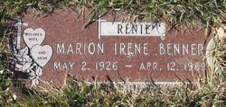
Marion Irene “Renie” Littlefield Benner
| Birth | : | 2 May 1926 |
| Death | : | 12 Apr 1989 |
| Burial | : | Big Sandy Cemetery, Big Sandy, Chouteau County, USA |
| Coordinate | : | 48.1801170, -110.1207500 |
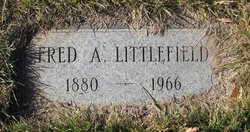
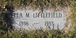
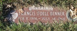
| Description | : | Obit from Find A Grave contributor "Cara": The Mountaineer, Big Sandy, MT, 20 Apr 1989 (excerpt) Marion Irene Benner was born May 2, 1926, to Fred and Lela Littlefield and was raised in Big Sandy. She taught at Dog Creek School for one year. She was married to Francis O'Dell Benner at Box Elder on November 13, 1945, and moved to Cascade in 1957. After her husband's death on July 14, 1968, she moved to Havre and was a secretary for Northern Transfer and Storage Co., retiring in 1984. She was a member of... Read More |
frequently asked questions (FAQ):
-
Where is Marion Irene “Renie” Littlefield Benner's memorial?
Marion Irene “Renie” Littlefield Benner's memorial is located at: Big Sandy Cemetery, Big Sandy, Chouteau County, USA.
-
When did Marion Irene “Renie” Littlefield Benner death?
Marion Irene “Renie” Littlefield Benner death on 12 Apr 1989 in
-
Where are the coordinates of the Marion Irene “Renie” Littlefield Benner's memorial?
Latitude: 48.1801170
Longitude: -110.1207500
Family Members:
Parent
Spouse
Siblings

Flowers:


Nearby Cemetories:
1. Big Sandy Cemetery
Big Sandy, Chouteau County, USA
Coordinate: 48.1801170, -110.1207500
2. Box Elder Cemetery
Box Elder, Hill County, USA
Coordinate: 48.3274000, -110.0095000
3. Kenilworth Cemetery
Chouteau County, USA
Coordinate: 48.2192001, -110.4188995
4. Rocky Boy Cemetery
Rocky Boy, Hill County, USA
Coordinate: 48.2572410, -109.7923690
5. Rocky Boy Gravel Cemetery
Rocky Boy, Hill County, USA
Coordinate: 48.2427720, -109.7596500
6. Cottonwood Lutheran Church Cemetery
Havre, Hill County, USA
Coordinate: 48.4545000, -110.1748000
7. Gildford Hill County Cemetery
Gildford, Hill County, USA
Coordinate: 48.5778008, -110.2957993
8. Clear Lake Cemetery
Chouteau County, USA
Coordinate: 47.7731018, -110.2514038
9. Hingham Union Cemetery
Hingham, Hill County, USA
Coordinate: 48.5601570, -110.4178980
10. Sunset Garden Park
Havre, Hill County, USA
Coordinate: 48.5531006, -109.8019028
11. Graceville Cemetery
Chouteau County, USA
Coordinate: 47.7505989, -110.0875015
12. Hungry Hollow Cemetery
Blaine County, USA
Coordinate: 48.2103004, -109.4677963
13. Highland Cemetery
Havre, Hill County, USA
Coordinate: 48.5463982, -109.6900024
14. Mount Hope Cemetery
Havre, Hill County, USA
Coordinate: 48.5540000, -109.7050000
15. Calvary Cemetery
Havre, Hill County, USA
Coordinate: 48.5457000, -109.6883000
16. Rudyard Cemetery
Rudyard, Hill County, USA
Coordinate: 48.5659500, -110.5390000
17. Riverside Cemetery
Fort Benton, Chouteau County, USA
Coordinate: 47.8402330, -110.6408830
18. Old Shep Gravesite
Fort Benton, Chouteau County, USA
Coordinate: 47.8369000, -110.6557000
19. Milk River Valley Church Graveyard
Hill County, USA
Coordinate: 48.6787180, -110.2261080
20. Museum of the Upper Missouri
Fort Benton, Chouteau County, USA
Coordinate: 47.8207000, -110.6642000
21. Inverness Cemetery
Hill County, USA
Coordinate: 48.5531340, -110.6688450
22. Grainbelt Cemetery
Hill County, USA
Coordinate: 48.6828003, -109.8657990
23. Montague Cemetery
Chouteau County, USA
Coordinate: 47.6783000, -110.4670000
24. North Havre Lutheran Church Graveyard (Defunct)
Havre, Hill County, USA
Coordinate: 48.6538903, -109.6815870